PART J -
PREREQUISITE: ATMOSPHERE, HYDROSPHERE, WEATHER AND CLIMATE
Introduction
Before we can properly consider weather, climate and the various catastrophes associated with them, we need to review (or learn!) some basic properties of air and water. If any of you have studied chemistry or physics in High School, you’ll quickly get through these pages; if not, take your time – these basics are critical to an appreciation of processes of weather and climate. It’s all very straightforward – so don’t panic!
Atmosphere
Let's begin this section with a brief description of the atmosphere as it exists already made; later, we'll consider how it was made.
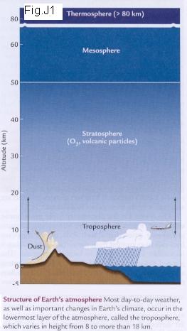
Scientists describe the present atmosphere as comprised of several layers, each with its own physical, chemical, and temperature characteristics (Fig. J1). From the bottom up, these layers are: (1) the troposphere, from surface level to about 12 km; (2) the stratosphere, up to about 50 km; (3) the mesosphere, up to about 80 km; and (4) the thermosphere up to 500-700 km. [The thermosphere is sometimes called the ionosphere, but strictly speaking the ionosphere is any electrified region of the upper atmosphere. At heights of 80 km (50 miles), the gas of the atmosphere is so 'thin' that free electrons can exist for short periods of time before they are captured by a nearby positive ion. The existence of charged particles at this altitude and above, signals the beginning of an ionosphere region.]
The lowest layer, the troposphere, contains about 80% of the mass of the atmosphere. It's thickest near the equator (close to 18 km) and thinnest near the poles (roughly 8 km). A sharp rise in the thickness of the troposphere occurs at mid-latitudes, and this exerts a fundamental control on global weather patterns (we’ll return to that point in a few minutes). The troposphere is the main layer of atmospheric circulation (Fig. J2).
The tropopause, the boundary between troposphere and stratosphere, is a surface of equal pressure. This boundary is marked by jet streams, which are narrow zones of swift high-altitude winds (Fig. J3).
The stratosphere is the zone above the weather, and temperature gradually climbs with height. This is also the zone that contains the ozone-enriched layer.
The mesosphere is the layer where incoming asteroids or meteoroids first begin to burn, and probably because of its lack of ozone, the temperature drops within it.
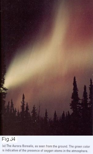
About 100 km above Earth's surface lays the outer atmosphere, or thermosphere (sometimes called the ionosphere). Air here is very thin and highly responsive to solar radiation. The varying velocity of solar winds especially affects it. During solar flares, the velocity of solar winds is greatly enhanced, and temperature in the thermosphere can rise to 1225oC as a result of solar bombardment, and then fall as low as 225oC. These dramatic temperature changes occur simply because there are very few molecules present to absorb and distribute heat. By the way, when we see the so-called Northern Lights, they are being produced in the thermosphere by ionization processes as an extraordinarily strong flux of electrons streams in from the Sun (Fig. J4).
Except possibly in the earliest stages of Earth evolution, when surface temperatures were very high, the only gaseous species that have been able to escape from the Earth's gravity field are H2 (hydrogen) and He (helium); Ne (neon), with an atomic weight of 20, does not escape, and the lightest of the major atmospheric gases have similar molecular weights NH3 – 17 (ammonia); H2O – 18 (water); CH4 – 16 (methane). Thus, the quantity of volatile or potentially volatile material in the whole Earth is assumed not to have changed since the earliest times, except for loss of hydrogen.
Origin of the Atmosphere
We can safely assume that Mars, Earth and Venus had virtually identical atmosphere compositions. If Earth's CO2 (carbon dioxide) that is tied up in limestone were evolved to the atmosphere, we'd again all be identical. At some time, it's likely that all three planets also had liquid water, inherited from comet and asteroid impacts, on the planet's surface.
Consider Venus first (Fig. J5). In the early days of differentiation, solar radiation readily penetrated the clouds of Venus to warm the planet's surface. As solar output increased and the surface heated, and as more CO2 from volcanoes entered the atmosphere (thus increasing atmospheric pressure), liquid surface water was probably evaporated. Eventually the atmosphere became so thick that radiation could not be reflected back into space from the surface; the greenhouse simply got stronger and the atmosphere got thicker. Finally, equilibrium was reached where the atmosphere (and particularly its outer shield of hydrogen sulfide droplets) was so thick that it reflected most of the in-coming solar radiation, thus keeping the whole planet at about 737o K constantly.
Next, look at Mars. There's plenty of surface evidence of surface water at some (early) stage. Apparently, there is still sub-surface ice (see: http://www.space.com/scienceastronomy/solarsystem/mars_ice_000920.html), but certainly no liquid water. It's been suggested that Mars' proximity to the asteroid belt left it exposed to a somewhat higher flux of meteorite impact than Earth, and the result was a gradual erosion of Mars' atmosphere. More likely, volcanism decreased as the (smaller) planet cooled. With the greenhouse gone (and the surface temperature dropped), liquid water became impossible. Today, the atmosphere on Mars is very thin, and surface temperatures change dramatically during a single day.
Comets and carbonaceous chondrites contributed the elements of the volatiles of Earth, Mars and Venus in the days of accretion and the following periods of heavy bombardment. So, the atmosphere compositions should have started out being the same for all three planets! Once volcanism became an active process on all three planets, the atmosphere and hydrosphere were maintained by degassing of the interiors.
Dynamics of the Atmosphere
Most weather-related phenomena originate in the troposphere. Although there is little mixing between the troposphere and the other divisions, the troposphere itself is thoroughly mixed and extremely dynamic.
Much of our concern with storms has to do with what water is doing in the troposphere. Water is a most unusual material since it can exist in three physical states at the Earth's surface. Whenever a compound goes through a change of state, energy is either absorbed by or released by the process. In going from a more ordered state (say ice) to a less ordered state (say liquid water), energy is absorbed. The amount of heat energy released or absorbed per gram of matter during a change of state is known as latent heat (look at the top part of Fig. J6). For example the latent heat of condensation (from less ordered to more ordered, thus released energy) is 2260 joules per gram, or 540 calories per gram (so...how many joules per calorie?). The latent heat of evaporation is 2260 joules per gram (=540 calories/g). Another way of saying that is: "Turning liquid water, heated to 100oC, into water vapor requires the input of 540 calories per gram of water, with no change in temperature during the change of state". Why do you feel cool on a hot day when you throw water on yourself? Because some of the 2260 j/g needed for evaporation of that water is absorbed from your skin, so your body temperature drops slightly.
The reason the troposphere is so dynamic is that air moves in convection cells in response to:
All these factors interact, of course.
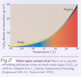
Density is always [mass/volume]. The air's density depends on its temperature, its pressure and how much water vapor is in the air (by the way, check out Fig. J7 to see how much variation there is in the amount of water vapor that air may contain). Consider dry air first. At sea level, if the air is completely dry and at 0oC, the density is 1.275 kg/m3. If we increase temperature, thus speed up the molecules of oxygen, nitrogen and other things in a 'box', the pressure on the box increases. If the heated air is surrounded by nothing but air (i.e. no 'box'), it will push the surrounding air aside, thus the air's density decreases as the air is heated. Pressure has the opposite effect to temperature, increasing the pressure increases the density; as you go higher, the air's pressure decreases. So, the air's density is lowest
[Example: a hot day in mile-high
The air's density is highest
[Example: a sunny, cold, winter day in Alaska]
You can convince yourself of the relationship between density and air temperature in another way. If you've ever used a manual pump to pump up a tire, you've noticed that the pump gets hot as you compress the air and force it into the tire (so the heat from the warm air is transferred to the pump). If you've put in too much and let some air out, it feels quite cool until it expands. These are two adiabatic processes (where the name comes from Greek meaning "no passage"). Adiabatic processes are so named because they are processes that occur without addition or subtraction of heat from any external source.
Warm air is less dense than cold air and therefore rises, creating convection cells in the process. Because of the temperature gradient in the troposphere, air is continually rising or falling. However, because air pressure decreases with increasing altitude, the rising air expands, and because there is no heat source within the troposphere itself, the rising air expands adiabatically and so its temperature falls. In the case of sinking air, the reverse happens, and it’s still an adiabatic process (no energy from any external source is involved in that convection of air).
If this is sounding complicated, sometimes it helps to simply express the same thoughts in other words. Here goes! 'Parcels' of air rise in the atmosphere if they become less dense than the surrounding air. The principal way to make air less dense is to heat it! Normally, we heat air close to the Earth's surface. As we heat a 'parcel' of air (let's say we're doing that over some area of bare rocks that are warmed by the sun), the heating causes expansion, becoming less dense, and the air rises. As the warm air rises to higher elevation, it is rising into a volume of the atmosphere with less pressure (look at Fig. J8; because there are fewer air molecules at higher elevations, there MUST be lower air pressure at higher elevations), and that results in additional expansion of the rising 'parcel'. BUT...that expansion requires the use or expenditure of heat energy, and no source of heat exists at higher elevations! The result MUST be that the rising parcel of air begins to cool. As a result of that, its density will slowly increase to match that of the surrounding air, and the parcel stops rising! Those processes that we've see happen to the parcel of air are, together, called adiabatic processes. OK? Just remember that the upward loss of heat is a dry process, completely independent of any amount of water that might be carried by the air - that's a whole other 'kettle of fish'!
Now.... let's put some water in the air! Latent heating is
the other process that can destabilize the atmosphere - and destabilization is
what storms are all about! As we already know, latent heating occurs as a wet
process, driven by water vapor, which weighs roughly a third less than the
mixture of gases that form the atmosphere (check it out with a table of
atomic weights if you don't believe me! In fact, here, let me prove it for you:
Humid air is lighter or less dense than dry air. I know that's not the way it feels, but it's true! To appreciate that fact, remember the basis behind Avogadro's Number: "Equal volumes of all gases at the same temperature and pressure contain the same number of molecules". What this means for us is that if some lighter gas molecules went into a "box" already filled with a heavier gas, and the volume, temperature and pressure stayed the same, some of the heavier molecules in the box would have to leave. If we didn't allow gas in the box to escape, adding more molecules of another gas would increase the pressure. So, adding the lighter molecules decreases the density of the gas in the box because they replace some heavier molecules. [Nitrogen has an atomic weight = ~28; Oxygen = ~32 and Water = ~ 18. In the free atmosphere, adding water vapor to the air replaces some heavier nitrogen or oxygen molecules with lighter water molecules.]).
Evaporation adds water vapor to the atmosphere at low elevations and causes a net decrease in the density of the air, which can then rise to higher elevations. As before (for dry air), the moist air rises, expands, and at some point cools to the temperature at which it becomes fully saturated with water vapor. Then condensation begins. Condensation releases latent heat (see Fig. J6 again), which partially opposes the cooling of the rising air parcel due to its expansion. The release of this heat in the air parcels also makes them less buoyant (or less dense) and allows them to rise much higher in the troposphere (sometimes up to 10-15 km). Eventually, the cumulative loss of most of the water vapor stops the release of latent heat that had kept them rising.
Actually, compared to the differences made by temperature and air pressure, humidity has a very small effect on the air's density.
Convection and Rotation
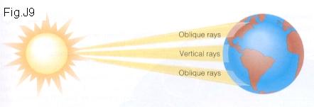
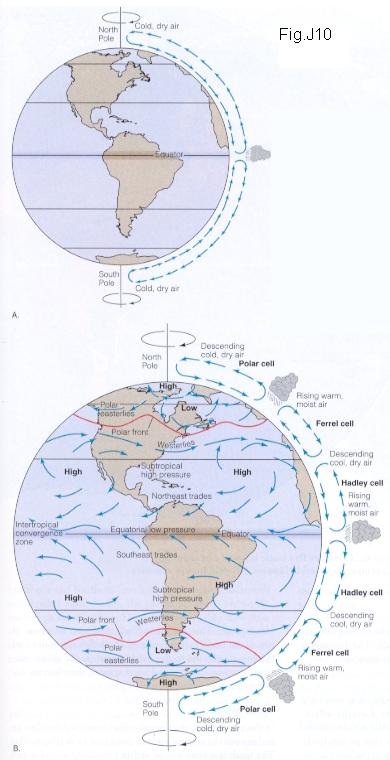
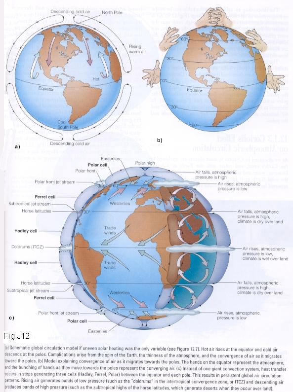
The air in the atmosphere does not simply rise from a higher temperature at Earth's surface into a cooler upper troposphere with no overall direction. We all know that more of the Sun's heat is received per unit of land surface near the equator than near the poles (Fig. J9). This uneven heating gives direction to convection currents. The heated air near the equator rises, and near the top of the troposphere it spreads outward in the direction of both poles. As the upper air travels northward and southward, it gradually cools, becomes heavier, and sinks. On reaching Earth's surface, this cool, descending air flows back toward the equator, warms up, and rises, completing the convection cycle. That's the way things should go without continents and without complications like rotation (Fig. J10).
The Earth's rotation messes up the simple pattern. The Coriolis effect, named after the 19th century French mathematician who first analyzed it, causes any body that moves freely with respect to the rotating Earth to veer to the right in the Northern Hemisphere and to the left in the Southern Hemisphere. This is true regardless of the direction in which the body may be moving [Fig. J11 is a simple-minded illustration of the Coriolis effect on the aiming versus impact sites for a rocket]. Both flowing water and flowing air respond to the Earth's rotation; the global pattern of ocean currents and wind systems therefore are influenced by the Coriolis effect.
By the way, one of the most dramatic effects of the Coriolis
effect happened in World War I when the Germans were
bombarding
In the atmosphere, the Coriolis effect breaks up the flow of air between the equator and the poles into belts (Fig. J12). The cells are called Hadley cells or Ferrel cells according to a north-south arrangement. Air movements associated with the boundaries lead to the formation of the polar jet stream or the called the subtropical jet stream. During major cold outbreaks, the polar front dives toward the equator. Consequently, the polar jet stream does the same. The polar jet stream often aids in the development of storms and it often tends to steer the storms. The subtropical jet stream can also help develop and steer storms.
While jet streams occur at cell boundaries in the upper atmosphere, they don't always occur. Sometimes the winds are so weak that they don't warrant that label. In fact, to be called a jet stream, the winds have to exceed 57 mph, or 35.4 kph.
This leads us, finally, into a consideration of winds!
Winds
Wind is air movement and is produced by the variations in pressure in the atmosphere; wind is thus the movement of air from a relatively high-pressure zone to a relatively low-pressure zone. Wind will initially tend to follow the pressure cells we noted earlier (Ferrell cells, Hadley cells, etc). Another factor affecting wind is friction; if the Earth had a frictionless surface, the wind would blow longer and harder than it does. On a map, we note the gradient of pressure by lines of equal value called isobars. When the isobars are close together, the airflow is much faster. If the Earth did not rotate, wind would blow in a straight line, but with rotation, it tends to be deflected by the Coriolis force (generally to the right in the northern hemisphere and generally to the left in the southern hemisphere).
As air near the ground flows inward from all directions toward a low-pressure center, frictional drag causes the flow direction to be across the isobars at an oblique angle. As a consequence, winds around a low-pressure center develop an inward spiral motion. By the same process, air flow spirals outward from a high-pressure area. The spiral flow patterns of air and clouds we see daily on forecast programs are nothing but those motions to or from pressure cells. If they fulfill certain criteria, spiral patterns around low-pressure cells are called cyclones and around high-pressure centers, anticyclones (Fig. J13).
The inward spiral flow in a cyclone causes convergence, which leads to an upward flow of air at the center of the low. The upward flow of moist air leads to cloud cover and rain. The outward spiral flow of an anticyclone is called divergence, which corresponds to an outward flow of air at the base. Remember, that cold air drawn downward is compressed and heated adiabatically, thus dropping the relative humidity and leading to clear, cloudless skies.
The Oceans
Introduction
The uppermost layer of the oceans is heated by solar radiation. Like air, water expands as it warms and becomes less dense, but in this case, the warmest layers are already at the top of the oceans, so they simply float on top of the colder, denser deep ocean. Winds mix the stored solar heat to maximum depths of 100 meters, a small fraction of the 4000-meter average depth of oceans. Some of this warm water is transported from the tropics toward the poles, and this poleward flow carries about half as much heat as is transported by the atmosphere.
There are two basic circulation systems in our oceans. One
is the wind-driven surface circulation, and the other is the deepwater density-driven
circulation, but they are connected. Before we get into the details, here are
some definitions and units to consider. Ocean current flow is expressed
in "millions of cubic meters per second" (a term somewhat
difficult to grasp!). Measurement of the
The
About 77% of world ocean volume is colder than 4oC, with salinities in the relatively narrow range 34.1 to 35.1. At the sea surface, only about 26% of the surface area is colder than 4oC, and it is within this area that the large volume of cold water acquires its characteristics before sinking and traveling along paths called deep ocean currents.
Surface Waters
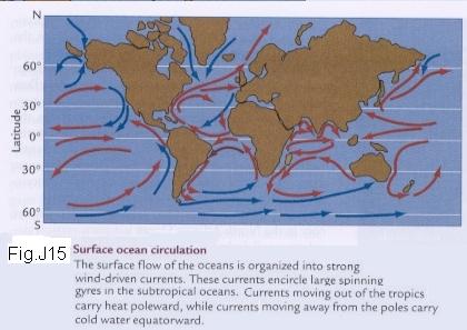
Most of the surface circulation of the oceans is driven by winds, and one of the most prominent results is huge gyres of water at subtropical latitudes (Fig. J15). These spinning gyres are mainly the result of an initial push (or drag) of the winds on the ocean surface, and of the Coriolis deflection of the moving water. Blowing wind exerts a force on the upper layer of the ocean and sets it in motion in the same direction as the wind. The Coriolis effect turns this surface flow to the right in the northern hemisphere (and to the left in the southern hemisphere). The top layer of the water, in turn, pushes or drags the underlying layers, which are deflected a little further to the right (or left) than the surface layer and are also slowed by friction. This process continues down into the water column for a depth of about 100 meters, creating a downward spiral of water gradually deflecting further and further to the right (or left) (Fig. J16).
In the
Sea level in the center of the lens sits 2 meters higher than the surrounding ocean. Water that flows away from this lens is turned to the right by the Coriolis effect, and this creates a huge subtropical ocean gyre spinning in a clockwise direction (or counterclockwise in the southern hemisphere).
Viewed over long intervals of time, most of the flow of oceans consists of water moving around in giant spirals. The volume of water circulating is enormous, about 100 times the transport of all Earth's rivers flowing into the oceans. Almost hidden in this recirculation is a much smaller amount moving through the gyres and carrying heat toward high latitudes.
The prevailing flow toward the equator in the deepest parts
of the gyres must be balanced by a return flow toward the poles, and this flow
is concentrated in narrow regions along the western gyre margins. In the
Another factor that affects poleward
heat transport only in the
This warm, northward-moving 'conveyor
belt' of water in the Atlantic transfers a huge amount of heat to the
atmosphere. At latitude above 50oN, that temperature transfer
from the warm
Deep-Ocean Circulation
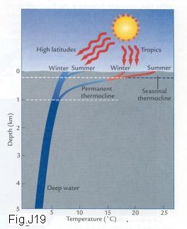
The poleward flow of warm water we have been describing occurs above the thermocline (Fig. J19), a zone of rapid temperature change between warm upper layers and cold water filling the deeper ocean basins. Actually, two thermoclines exist: (1) a deeper permanent portion that is maintained throughout the year, and (2) a shallower portion that changes as a result of seasonal heating (These will be very important when we look at El Nino effects and climate changes).
We just learned about warm poleward flow water sinking to flow back toward the equator; the overturning circulation is called the thermohaline flow (the 'haline' part comes from halite, meaning salt).
Deep waters form and sink because they become more dense that the underlying water. Seawater contains dissolved salt, making it 3.5% more dense than freshwater (i.e. it contains 35 parts per thousand of salt). The density of ocean water can be increased at low latitudes when the atmosphere evaporates water vapor, leaving the remaining water saltier (more dense). The density of seawater can also be increased at high latitudes by formation of sea ice, a process that stores freshwater in ice and leaves the salt behind. Another way to increase the density of ocean water is by cooling it. Saltwater is slightly compressible, which means it loses volume and gains density when it is cooled by the atmosphere. Cooling can occur either because warm ocean water is carried poleward into cooler regions or because colder air masses move to lower latitudes. Salinity and temperature generally work together to raise the density of water.
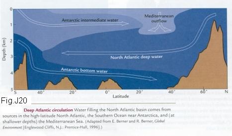
Most of the deepest oceans of the world are filled by water
delivered from only two regions: the high-latitude
This is the end of all Prerequisite material.
)