
Click her to go to 'Figures/Overheads' section.
Click here to return to course outline.
Click here to return to W.R. Church's home page.
Click here to return to Earth Science course list.
Church, W.R. 1997, Documentation of a 1450 Ma contractional orogeny preserved between the 1850 Ma Sudbury impact structure and the 1 Ga Grenville orogenic front, Ontario: Discussion: publish.uwo.ca/~wrchurch/.
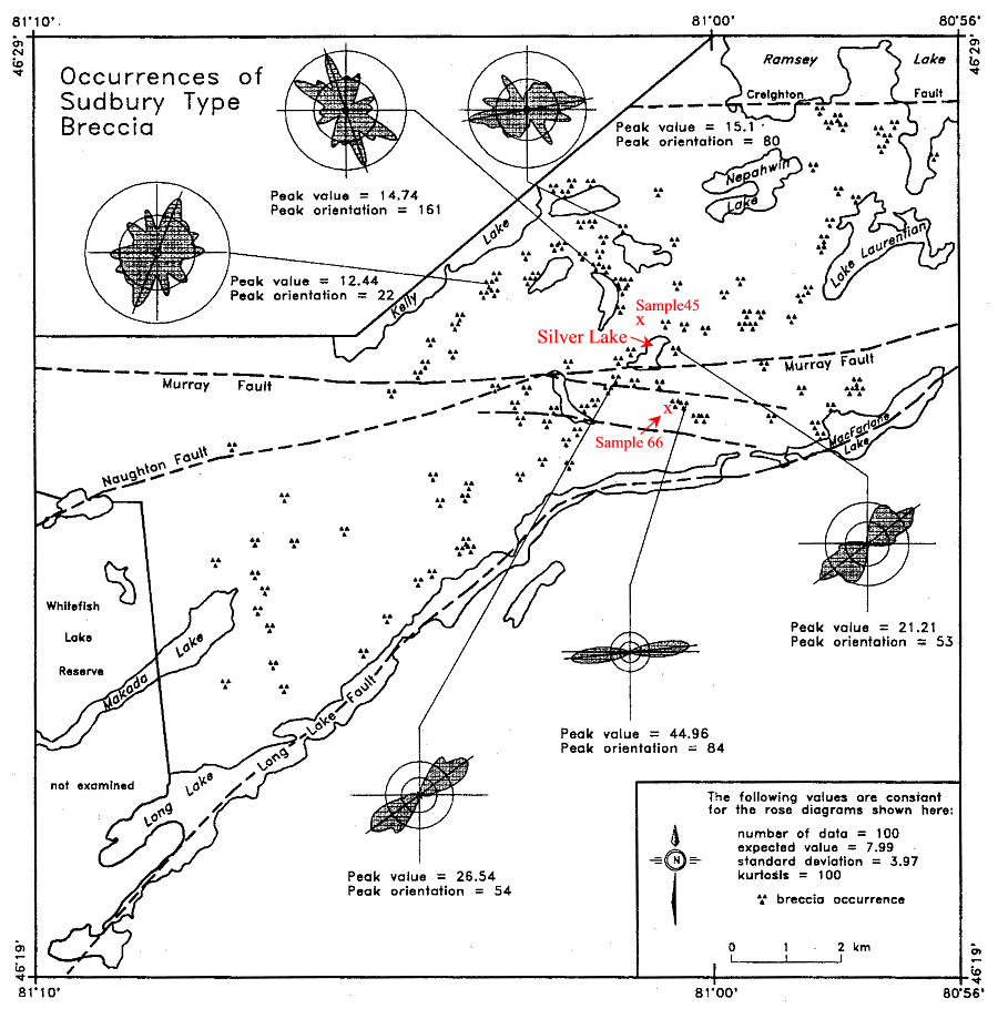
Fueten and Redmond (1997) have
established on the basis of an analysis of quartz c-axis orientations and
grain shapes in Mississagi quartzites, and of clast orientations in Sudbury
breccia, that the area of Huronian rocks between Sudbury and the
'Grenville Front' can be subdivided into three fault bounded structural
panels.
Quartz grains in the northern
panel north of the Murray fault are very little strained, and clasts in
Sudbury breccia show no preferred orientation.
In the central panel between
the Murray and Long Lake faults, strain as indicated by grain shape is
highly variable. At three localities in the vicinity of Silver Lake, clasts
in Sudbury breccia show a marked preferred orientation, which in one case,
southeast of Silver Lake, seems to correlate with a preferred quartz shape-fabric
in quartzites (sample 66). Sudbury breccia
clasts showing a marked preferred orientation also occur southwest of Silver
Lake at the eastern end of the ENE-WSW high strain zone along which were
collected samples 47, 48, 49, and 63. Given that some high strain breccia
zones and the locations of samples of quartzite with strong preferred shape
orientations are indicated to occur north of the Murray Fault, it would
seem that the latter structure approximately marks the onset of occurrence
of non-pentrative strain in Mississagi quartzites. The quartz c-axis
patterns in the middle panel between the Murray and Long Lake faults are
also very variable, again implying non-penetrative deformation in this
panel.
South of the Long Lake fault quart c-axis
orientations exhibit strong point maxima and deformation in the southern
panel in the samples collected by Richmond and Fueten is strong and
penetrative.
On the basis that Sudbury
breccia clasts north of the Murray fault zone show no preferred alignment,
and folds can be traced north of the Murray fault to the west of the study
area, Fueten and Redmond (1997) suggest that the bulk of the deformation
north of the Murray fault zone in the study area pre-dated the 1850 Ma
impact event. This implies that the large scale regional folding during
the 1890-1830 Ma Penokean deformation occurred prior to 1850 Ma, and that
while significant deformation affected the area following the Penokean
orogeny, they were unable to correlate any deformational features
with the emplacement of the 1750 Ma phases of the Chief Lake Complex. They
further suggest that the ca. 1750 Ma magmatic event was passive, representing
anorogenic magmatism, and that the deformation fabric in rocks south of
the Long Fault represents an important post-1.46 Ma phase of deformation
that may have penetrated as far north as the southern margin of the sudbury
basin. These useful suggestions are discussed in the wider context of the
polyphase deformation history of the Huronian of the Espanola wedge.
Figure 1. - Structural elements of the Southern and Grenville Province southwest of Sudbury
The
polyphase structural architecture and deformation history of the Espanola
Wedge
The Long Lake fault as defined
by Fueten and Redmond may be the continuation of the Lake Panache - Apsey
Lake fault which separates the deformed Huronian into two distinct structural
panels. To the south of the fault Huronian rocks occur in the form of large
scale, tight vertical folds ( La Cloche and Bass Lake synclines; Mcgregor
Bay anticline), whereas to the north of the fault folds in the Huronian
are relatively open smaller scale structures. Argillites involved in the
tight folds of the southern structural panel do not exhibit a coeval axial
planar mica fabric.
The folds (D1) of the southern
panel are transected by Nipissing diabase and Sudbury Breccia, in
that order, and are therefore pre-2.2 Ga, pre-impact, and pre-Penokean
- if this term is restricted to deformation associated with the 1.86 Penokean
collision event of Michigan-Wisconsin. The tectonic environment of formation
of the early large scale folds is not known, but an analogy could be drawn
with the enigmatic first-phase fold deformation of the Moine-Dalradian
clastic wedge of the Scottish Caledonides, and the tight vertical folding
induced in the Port Moresby continental margin sediments by obduction of
the Papuan-New Guinea ophiolite. The most prominent planar fabric
in Huronian rocks of the southern panel is a slaty cleavage (D2) of
variable intensity which cuts across the earlier folds, Nipissing diabase
and Sudbury breccia. It also acted as the locus of development of a third-phase
fold and crenulation cleavage fabric (D3). Aluminous quartzites of the
Lorrain Formation contain pre-deformation pyrophylite and kyanite, and
post-deformation andalusite; and cleaved pelitic rocks contain randomly
oriented porphyroblasts of late-growth biotite. Microscopic garnet occurs
rarely in some cleaved argillites of the Gowganda formation at Whitefish
Falls.
On the other hand,
the prominent open folds north of the Apsey Lake fault (cf. Card, 1978;
Map 2360) fold a fine grained slaty cleavage (D2') which
cuts Sudbury breccia bodies in this zone. The strain and metamorphism associated
with the cleavage is low, and shatter cones can be recognized in quartzose
rocks at least as far west as Anderson Lake, south of Espanola. It would
seem likely that the quartzose rocks of this panel never were deformed
sufficiently to develop a strong Penokean fabric, and it would seem equally
unlikely therefore that the quartz c-axis fabrics described by Fueten and
Redmond in rocks north of the Long Lake fault are reset Penokean-aged
fabrics. Nevertheless, the presence of an axial planar cleavage in
argillites of this zone attests to the existence of a post-Sudbury breccia
(post -impact) phase of deformation. A similar cleavage fabric is also
found in the argillites, Sudbury breccias, and even pelitic material filling
shatter cone fractures, immediately south of the Sudbury Basin at Copper
Cliff. Again however, the associated quartzites exhibit little in
the way of ductile deformation. If the slaty cleavages in both the southern
and northern panels are coeval (D2=D2'), it would not be unreasonable to
correlate the prominent folds (D3') of the northern panel with the strain
slip fabric (D3) of the already vertically folded southern panel.
In contrast to the rocks
of the Anderson Lake low grade zone, the Huronian McKim Formation north
of the Espanola fault, exhibits a well developed mica cleavage (D2') which
cuts across Sudbury Breccia bodies and also post-dates growth of chloritoid
and staurolite. An earlier poorly developed bedding plane cleavage (D1'),
best delineated by oriented laths of ilmenite is however sometimes present
in argillaceous units of the McKim, suggesting that these rocks may
have suffered some degree of deformation prior to the Sudbury event.
In Baldwin Township north of Espanola, the more prominent cleavage (D2')
is coarse grained and commonly refolded by a penetrative crenulation fabric
(D3'), which is further overprinted by a late phase of crystallization
involving garnet growth and the generation of an annealed quartz fabric.
The effect of the Murray fault in disrupting the architecture of the Huronian
within the Baldwin structural panel is minimal, and the speculations of
Zolnai et al (1984) proposing 15 km of structural relief along the Murray
fault are therefore debateable. The domal metamorphic zonation is perhaps
controlled by some process of thermal convection related to granite
intrusion rather than by the upthrusting of deeply buried rocks.
Furthermore, at the western end of the Baldwin metamorphic belt the ca
1.75 Ma Cutler granite is located within a late D3' fold which folds a
prominent post-Sudbury Breccia foliation (D2') that is either syn- or pre-granite
intrusion. Also, deformed Huronian rocks of the Espanola Wedge are transected
by the 1.475 Ga Croker Island complex, described by Card et al. (1972)
as a an epizonal, post-tectonic intrusion exhibiting a narrow hornfels
contact zone. Consequently, it seems unlikely that all the deformation
fabrics, including the D3/ D3' folds, are strictly Penokean (1860 Ma) in
age.
The
deformation history of the Sudbury Basin
Within the Sudbury basin,
neither the fold deformation of the Whitewater Group nor the strain fabric
of the South Range shear zone are likely to be coeval with the pre-Sudbury
Breccia deformation outside the basin. However, it is uncertain whether
the folding of the Whitewater Group is equivalent to the prominent post-Sudbury
Breccia foliation (D2/D2') common to all structural domains in the Espanola
Wedge, or, alternatively, to the later D3/D3' folds. The deformation
represented by the South Range shear event was separated from the D3/D3'
fold event outside the Sudbury Basin by the intrusion of the undated ENE
trending 'trap' dyke suite, and given that the 'Trap' dykes were affected
by the late stage metamorphism (pleochroic amphibole mantling relict cores
of pyroxene and amphibole) that produced the 'Cutler-Baldwin'-type annealed
fabrics in the staurolite-bearing McKim argillites outside the Sudbury
Basin, it remains possible that the South Range shear deformation was a
late non-penetrative c. 1.75 Ga event. Furthermore, south of the
Murray Fault about 1.5 km south of the SE corner of Silver Lake on the
road to Rheault, sheared Huronian quartzites are cut by undeformed
dikes of undated microgranite. On the other hand, ENE trending mafic dikes
within mylonitized megacrystic granites at the Grenville Front near
Alice Lake have suffered the same deformation as the granites, and if these
granites belong to the 1.46 Bell Lake intrusive suite rather than the 1.75
Killarney suite then the 'Trap' dikes could be younger than 1.75 Ga, as
could also therefore the age of the South Range shear. In this case the
growth of amphibole in 'Trap' dikes within the South Range shear would
be of only local significance.
The
deformation history of the Grenville Front region
As one approaches the Grenville
Front at the eastern edge of the Espanola wedge, Huronian stratigraphic
units and fold structures take up an orientation parallel to the Front,
and the continuation of the axial plane trace of the large scale La Cloche
Range/ McGregor Bay syncline perhaps passes through the large enclave of
Lorrain formation rocks within the Chief Lake batholith at Chief Lake (see
above figure). Outcrops of quartzite east of the Killarney granite may
then be remnants of the west facing limb of the syncline. At Bell Lake
(Brooks, 1976) the foliation in argillites of the Gowganda Formation is
crenulated by folds related to the change in strike of the Huronian into
parallelism with the Front, and both structures are overprinted by the
coarse growth of andalusite and cordierite. The mica and quartz-feldspar
fabric is completely annealed. Whether porphyroblast growth is related
to the Bell Lake or Killarney granites is not known but andalusite does
appear in Huronian rocks marginal to the Killarney complex all along its
length to the southwest of Bell Lake. It would seem possible therefore
that the overall architecture of the Huronian, the Sudbury basin, and even
the northernmost part of the 'Grenville' is determined by the three phases
of deformation that pre-date intrusion of the 1.46 Ga 'Bell Lake'-type
intrusions. Consequently, the deformation of the aluminous-schists
of the Pecors Formation south of Long Lake may be no more than a
non-penetrative phase of post-1.46 deformation coeval with the local non-penetrative
deformation found in phases of the Bell Lake granite.
References:
Card, K.D. et al., 1972. The Southern Province, in Variations in Tectonics
Styles in Canada, Geol. assoc. Canada Special paper Number 11, 335-380.
Card, K.D., 1978. Geology of the Sudbury-Manitoulin Area, Districts
of Sudbury and Manitoulin: Ontario Geological Survey, Geoscience Report
166, 239p. (Accompanied by Map 2360).
Church, W.R. and Young. G.M. 1972. Precambrian geology of the southern
Canadian Shield with emphasis on the Lower Proterozoic (Huronian) of the
North Shore of Lake Huron: XXIV International Geological Congress, Montreal,
Excursion A36 - C36, 65p.
Frarey, M.J. and Cannon, R.T., 1969: Lake Panache - Collins Inlet,
Ontario, Geological Survey of Canada Map 21-1968.
Fueten, F. and Redmond, D.J., 1997. Documentation of a 1450 Ma contractional
orogeny preserved between the 1850 Ma Sudbury impact structure and the
1 Ga Grenville orogenic front, Ontario: BGSA v. 109, no. 3, p. 268-279.
Palmer, H.C. Merz, B.A., and Hyatsu, A., 1977. The Sudbury dikes of
the Grenville Front region: paleomagnetism, petrochemistry and K-Ar age
studies: CJES, v. 14, p. 1867-1887.
Pye, E.G., 1984. The origin of the Sudbury Structure, in Pye, E.G.,
Naldrett, A.J., and Giblin, P.E. The Geology and Ore Deposits of the Sudbury
Structure: OGS Special vol 1, 448p. Zolnai, A.I. et al., 1984. Regional
cross section of the Southern Province adjacent Lake Huron, Ontario: implications
for the tectonic significance of the Murray Fault Zone: CJES, v. 21, no.
4, p. 447-456.
Relevant quotes:
p. 268 The Huronian metasedimentary rocks were folded (Fig. 1) prior
to the intrusion of the 2219 Ma Nipissing diabase sills (Card, 1978;
Bennett et al., 1991) and also during the 1890-1830 Ma Penokean orogeny
(Van Schmus, 1980; Hoffman, 1989a).
p. 268 Huron Supergroup rocks form an Early Proterozoic assemblage
....that has been correlated with the Marquette Range Supergroup in the
southeastern portion of the Animikie Basin (Morey, 1993). p. 269 The (Nipissing
Diabase) sills are folded but lack a penetrative tectonic fabric.
p. 268 Previous studies of the granitoids have also played an important
role in the positioning of the northern boundary of the Grenville Province
in this area (e.g. Quirke and Collins, 1930; Quirke, 1940; Henderson, 1967;
Brocoum and Dalziel, 1974; Davidson, 1986).
p. 271 In thin section staurolite and andalusite porphyroblasts are
observed to be partially to completely replaced by fine grained retrograde
muscovite and chorite. ....the regional foliation is deflected around
the porphyroblasts of staurolite and andalusite, developing well-defined
pressure shadows, indicating the amphibolite facies metamorphism was pre-tectonic
or early syn-tectonic. Phyllosilicates surrounding the porphyroblasts are
elongated in the plane of the foliation and parallel to the southeast-
plunging lineation.. A crenulation cleavage overprints the primary foliation
defined by the alignment of the phyllosilicates.......Olivine diabase dikes
of the Sudbury swarm south of Long Lake have not been metamorphosed, indicating
that metamorphism and deformation predated intrusion of the dikes and is
therefore pre-1235 Ma and pre- Grenvillian orogeny.
p. 273 the rocks underwent little deformation after the formation
of the breccia (Fig 3a), which signifies that brecciation is at least post-Penokean.
p. 276 phases of the Chief Lake Complex were intruded around 1749
and 1464 Ma. At the 1464 Ma sample site the massive granite grades to high-angle,
reverse-shear mylonite over several meters and is in contact with mylonitized
Huron Supergroup rocks, indicating that contractional deformation postdates
the ca. 1750 Ma intrusive events.
p. 276 Sudbury breccia clasts north of the Murray fault zone show
no preferred alignment, and folds can be traced north of the Murray fault
to the west of the study area (Davidson, 1992). We therefore suggest that
the bulk of the deformation north of the Murray fault zone in the study
area pre-dated the 1850 Ma impact event. This implies that the large scale
regional folding during the Penokean deformation occurred prior to 1850
Ma, as suggested by Zolnai et al (1984).
p. 276 This deformation (south of the Murray fault) must postdate
the 1850 Ma Sudbury event, and the features observed were most likely produced
by brittle tightening of the existing Penokean folds.
p. 278 we have argued herein, on the basis of random Sudbury breccia
clasts orientation (in rocks north of the Murray Fault), that significant
Penokean-aged deformation had ceased prior to the 1850 Ma impact event.
p. 278 The Penokean orogeny is thought to have extended from 1.96
to 1.835 Ga (Hoffman, 1989b) and is responsible for the regional folds
in the Southern Province and for a major displacement on the Murray fault
zone documented by Zolnai et al. (1984).....we suggest that active Penokean
folding and thrusting had essentially terminated by 1850 Ma when the Sudbury
impact structure formed. While significant deformation affected the area
following the Penokean orogeny, we have not been able to correlate any
deformational features with the emplacement of the 1750 Ma phases of the
Chief Lake Complex. We suggest that the ca. 1750 Ma magmatic event was
passive and represents anorogenic magmatism.
The Grenville Front Problem south of Sudbury - history of data acquisition
Quirke and Collins (1930) concluded that "the Huronian
formation, traceable eastward for 225 km from Sault Ste Marie, does not
terminate at the Grenville Front but exists south of the Front in a highly
recrystallized and metamorphosed state.", a conclusion also reached by
Phemister (1961). Brooks (1967) mapped the 'Grenville Front' in the vicinity
of Bell Lake and concluded that 'Grenville Front' tectonism (development
of slip-planes) was synchronous with the generation of the 'Killarnean'
granites, that there was slightly later granite intrusive activity accompanied
by the contact metamorphic growth of andalusite and cordierite, and that
the younger granites (Bell Lake granite) were subject to non-penetrative
cataclastic deformation that produced zones of cataclastic gneiss. The
Bell Lake granite was also indicated to contain a primary foliation marked
by the parallelism of microcline phenocrysts (Brooks, 1976). He also showed
that at Johnny Lake a straight trending olivine-diabase dyke (Sudbury diabase)
cutting the Bell Lake granite was cataclastically deformed along with the
granite.
Krogh and Davis (1969, p. 230) obtained a
1.75 Ga Rb-Sr four point isochron age for rocks collected from the Chief
Lake complex of granite rocks in the vicinity of Broder Lake (Henderson,
1967, p. 279), and a Rb-Sr age of 1.6 Ga for muscovite from a northeast-trending
granite dyke that intrudes Huronian along the northwest margin of the Chief
Lake complex. They also reported an age of 1.45 Ga for muscovite from a
strongly foliated granite. Krogh and Davis concluded that the Chief Lake
granite complex was "intruded into the 'Grenville Front' 1700 m.y. ago
and that it underwent plastic... (southeast margin)... and brittle deformation...
(northwest margin)... then or at some time earlier than 1450 m.y. ago."
(Krogh and Davis (1970, p. 310) later determined an age of 1.63 Ga for
muscovite in the undeformed part of a variably Grenville deformed pegmatite
located southeast of the 'Grenville Front' in the vicinity of Highway 69,
and an age of 988+/-2 Ma for monazite in a cataclastically deformed pegmatite
at the same locality (Krogh 1994, p. 971).)
Krogh and Davis (1970) recognized the existence
of two ages of granite along the 'Grenville Front', and also reported that
pegmatites containing coarse muscovites with ages of 1.44-1.47 Ga cut the
foliation in coarse-grained impure quartzites south of the Bell Lake granite,
and near Carlyle Lake (pers. comm . to Brooks, 1976) contain inclusions
of mylonitized Killarney granite. (The Killarney granite was subsequently
dated by Davidson and Van Breemen (1994) as having a zircon age of 1.74
Ga, and the Bell Lake granite a zicon age of 1.47 Ga (Van Breemen and Davidson,
1988).)
The firt serious mapping of the southwestern part
of the 'Grenville Front' region by Frarey and Cannon (1969) separated the
Killarney granite (unit 7b) from the Bell Lake granite (unit 7a), showed
the existence of a foliation in the eastern margin of the Killarney granite
(unit 9d), and demonstrated that dykes of the Sudbury dyke swarm not only
transected the granites but extended well to the southeast of the 'Grenville
Front'. Subsequently, the Grenville Front was located coincident with a
major myolite zone along the eastern margin of the granite belt. (The location
of the mylonite zone at the Killarney end of the belt was susequently relocated
further east by Davidson (1986).)
Study of that section of 'Grenville Front' southeast
of Sudbury led Brocoum and Dalziel (1974) to propose that the supposed
Grenville deformation at this locality was Penokean and entirely older
than the dykes of the Sudbury swarm, and that "the major ductile deformation
of the rocks of the Sudbury Basin, the eastern part of the Southern Province,
and the northwesternmost Grenville Province was coeval". They allowed however
that post olivine-diabase cataclastic (brittle) deformation was also present
along the length of the 'Grenville Front' (Brocoum and Dalziel, reply to
Brooks, 1976).
Lumbers' map of the Burwash region (1975) showed
the 'Grenville Front' termed as the Grenville Front Boundary Fault
and located at the western limit of penetrative deformation within the
granitic rocks of the Front.
A paleomagnetic and chemical compositional study
of Sudbury diabases in the Southern and adjacent Grenville provinces by
Merz (1976) showed that Sudbury diabases in or near the Grenville Provinve
had had their TRM reset as a result of Grenville metamorphism. Merz also
recognized that some of the dikes, currently referred to the Grenville
dyke suite, were Paleozoic in age. Sampling of Sudbury diabase dykes in
the Tyson Lake region in 1972 (Church, 1992) showed that the Grenville
metamorphism was recognisable in the growth of microscopic garnets in the
chilled margins of dykes which otherwise appeared undeformed, other than
where they were cut by non-penetrative shear zones, and also unmetamorphosed.
Davidson (1986) confirmed the contention of Krogh
and Davis that the Killarney granite had undergone deformation before emplacement
of pegmatite and Sudbury diabase, as well as Card's (1976) discovery of
volcanic rocks in large xenoliths near the margin of the Killarney granite.
He also showed that the linear deformation fabric within the eastern margin
of the Killarney granite had a different geometry to that in the bordering
Grenville gneisses.
Davidson and Bethune (1988) concurred with Mertz's
contention that the metadiabase segments cutting 'Grenville' gneisses were
correlative with Sudbury diabase dykes in the Southern Province. They documented
the presence of metamorphic orthopyroxene in dykes at Broker Lake, and
suggested that this indicated considerable uplift across the northeast-striking
faults and mylonite zones associated with the 'Grenville Front',
but little lateral post-dyke displacement. They further suggested that
the 'Grenville Front' in the Tyson Lake area be relocated slightly to the
southeast to mark both a change in a change in the geometry of the dikes
and of the style of deformation from brittle to ductile in the Sudbury
diabase dykes of this region, even although the ductile deformation zones
were non penetrative. In particular, Davidson and Bethune suggested that
the intrusion of the Sudbury dykes was syntectonic with respect to Grenville
style deformation, which therefore must have begun before c. 1.24 Ga in
the Tyson-Killarney region.
This theme was repeated in Green et al. (1988) who
proposed that the GLIMPCE seismic fabric of Grenville rocks beneath Georgian
Bay about 70 km south of the exposed rocks on the north shore of this region
was produced by : 1) depression to lower crustal depths of rocks along
the northern margin of the Grenville Province as a result of the progressive
stacking of microterranes against the Superior craton, possibly coeval
with island-arc magmatism at 1.25-1.3 in the Grenville Central Metasedimentary
Belt, and 2) thrusting, after intrusion of the Sudbury diabase dykes, of
the rocks buried deeply by the earlier stacking episode back up to shallow
depths. Accordingly, the GLIMPCE seismic fabric of the Grenville
Front Tectonic Zone thus largely reflects the formation of highly reflective
shear and mylonite zones during late Grenville thrusting under ductile
conditions, rather then any pre-Sudbury diabase front-parallel deformation
fabric.
Geochronological studies of Haggart et al. (1993)
showed that between the Grenville Front mylonite zone east of Killarney
and Beaverstone Bay, titanites were progressively reset to Grenville ages,
with complet resetting being achieved in the vicinity of the eastern shore
of Beaverstone Bay. Krogh (1994) also showed that monazite in an
undeformed in situ pegmatite (Tyson Lake locality 1e) containing inclusions
of lineated Huronian and undeformed pegmatite has a concordant age
of 1.45 Ga, as does titanite (locality 1b) in an undeformed pegmatite cutting
gneisses southwest of Tyson Lake. Grain tips from zircons in pegmatite
at Tyson Lake and Beaverstone Bay also have near concordant ages of 1.45
Ga, whereas titanite from undeformed pegmatite at Beaverstone Bay lies
on a 1.45 Ga - 977 Ma chord, 78% discordant towards a time of Grenville
resetting. The resetting approximates changes in the metamorphic
mineralogy of the Sudbury diabases as they are traced into the Grenville,
but with the first appearance of garnet in the chilled margins of the diabases
at Tyson Lake providing a more sensitive record of the Grenville thermal
event.
More recently Bethune (1998) has however proposed
that the erratic course of Sudbury diabase dikes east of Tyson Lake is
the result of 1B - 1C type buckle folding, although the proposal is qualified
by the statement that some prominent 90 degree bends are not easily reconciled
with buckle folding. Furthermore, the supposedly buckled dyke east of Aqua
Lake transects the axial plane traces of tight folds outlined by paragneiss
units in this area, and the gneisses here form part of the zone within
which undeformed pegmatites have pre-Grenville 1.47 Ga ages. Panels of
rock transected by linear east-west trending segments of Sudbury diabase
and bordered by zones of ductile mylonite also continue to appear well
to the east of this zone, and Grenville deformation may be fully penetrative
in character only east of the Beeftea Lake Sudbury Diabase location.
The distribution of deformed and metamorphosed Sudbury
diabase (unit 48) on the Burwash Map sheet of Lumbers (1975), and the presence
of penetrative ductile folding in 'Grenville' rocks on the west flank
of the Bigwood synform as far west as a boundary line drawn approximately
between Oak Lake, Beeftea Lake and Chaughis Bay (?) on the north
coast of Georgian Bay, might indicate that the penetrative fabric of the
rocks to the west of this line still largely reflects pre-Grenville deformation
events, the earliest of which likely even pre-dates intrusion of the c.
1.75 Ga Killarney granite. An old deformation fabric is possible preserved
in a shear pod of 2.45 Ga anorthosite in Dryden Township, and in
agmatite associated with the 1.75 Ga (Prevec, 1994) mafic rocks of the
Wanapitei shear pod, both of which are cut by undeformed, garnet-bearing
Sudbury diabase. On the other hand, agmatites, gabbros and dike units
of the Red Deer Lake shear pod show no signs of pre-Sudbury diabase
internal penetrative deformation. Consequently, while non-penetrative deformation
in this sector may well include the formation of Grenville age (post-Sudbury
diabase) mylonite zones and the local development of brittle foliation
fabrics in the 1.47 Ga Raft Lake (Davidson and Ketchum, 1993 and perhaps
Bell Lake intrusions, there is little evidence to support the possibility
that the deformation fabric in the gneisses west of the Oak Lake-Beeftea
Lake line are of this age. In this respect it might also be noted that
quartzite at Beaverstone Bay (Krogh, 1989, p. 63) contains not only euhedral
grains of Archean zircon but also 1.75 Ga zircons in the form of long needle-like
crystals.
While it is clear therefore that the boundary between
Huronian metasediments and highly deformed gneisses in the region between
Wanapitei and Brodil Lake marks the sharp northern limit of the Grenville
Province, south of Brodil Lake the northern boundary of Grenville penetrative
deformation is more likely to be marked by a necessarily 'fluid' line between
White Oak Lake and Chaughis Bay, and some distance to the east of the ductile
mylonite zone used by the GLIMPCE project as the eastern boundary of the
Grenville Front Tectonic Zone. Since the penetrative fabric west of this
line is likely to be pre-1.47 in age, the gneisses within this belt should
be ascribed to the Southern structural province.
While it is likely therefore that K-feldspar megacrystic
rocks of the Killarney-Tyson lake sector of the "Grenville Front"
exhibit both a primary foliation (Brooks, 1967) and a younger cataclastic
mylonitisation, and while the latter may locally affect adjacent rocks
of the Southern Province, it is not clear yet how this fabric is distributed
either within the granites to the south or within the Huronian rocks along
strike to the southeast, or the extent to which the fabric may be related
to the pre-1.47 Ga foliation of the eastern deformed zone of the Killarney
granite.
Figure 1. Structural elements of the Southern Province.
RETURN TO:
Click here to return to beginning.
Click here to return to course outline.