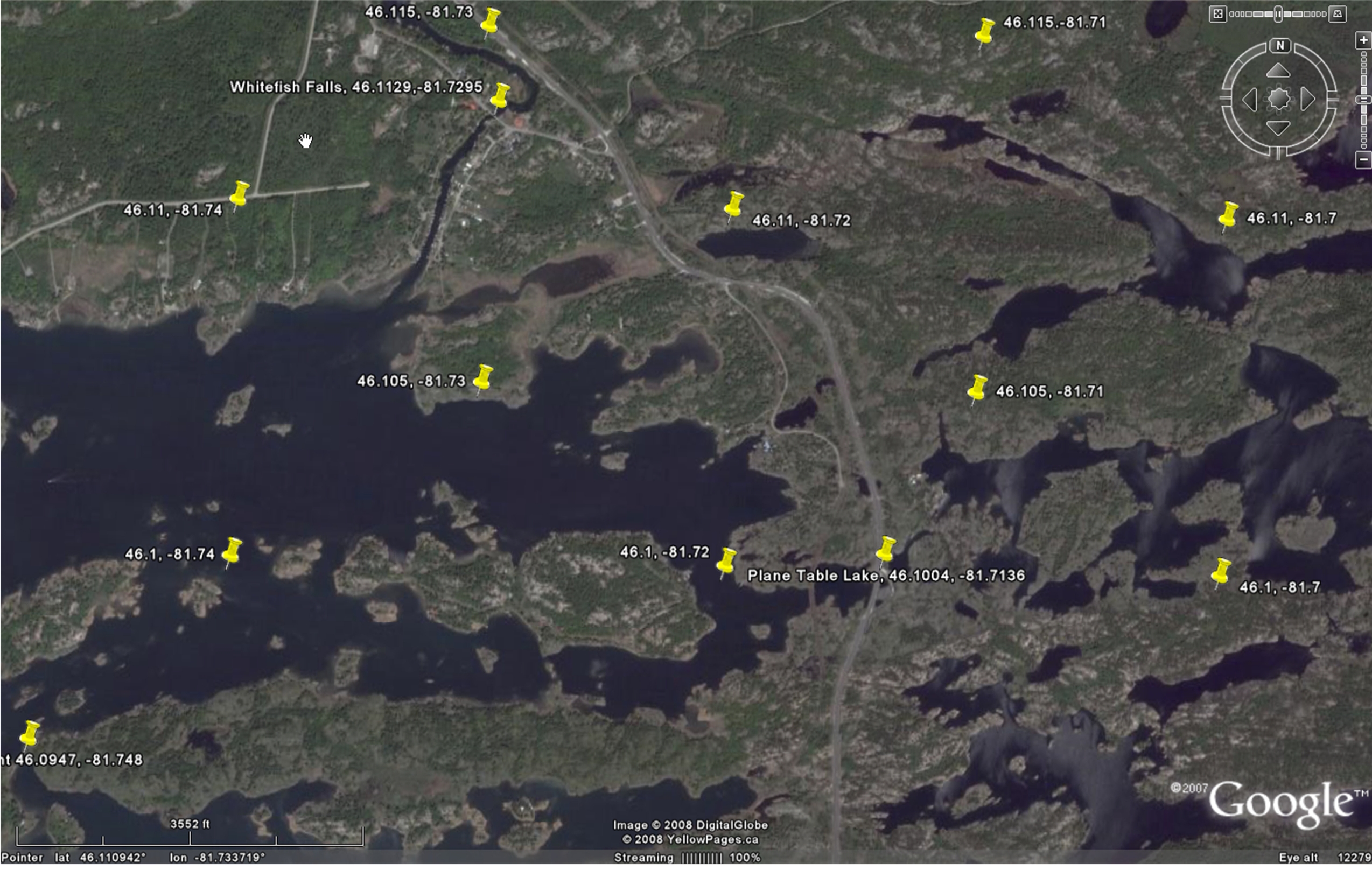
Whitefish Falls
Departure
The excursion to Sudbury will leave PROMPTLY from the rear loading dock of the B & G Building at 7.30 A.M., May 1st. Each student is required to fill out a standard University 'Release and Assumption of Risk' form. This should have been done at the time the course fee is paid to the departmental secretary. If you haven't done so, please do see the secretary. Do not forget to bring your OHIP card - in case you should need medical attention.
Participants: (if your name is not on the following list, contact Dr Osinski as soon as possible.)
TENTATIVE Program
The aim of the course is to provide Geology students with an opportunity to prepare and then carry out a mapping program in an area of deformed and metamorphosed sedimentary rocks. The mapping sites are all located in the vicinity of Whitefish Falls, southwest of Sudbury, Ontario.
Why the Whitefish Falls region?
Whitefish Falls is used by many schools as a base for their 2nd-year field instruction, mainly for logistical reasons, the excellent outcrop, and the fascinating story the rocks have to tell about the evolution of the Canadian Shield during the Proterozoic Eon.
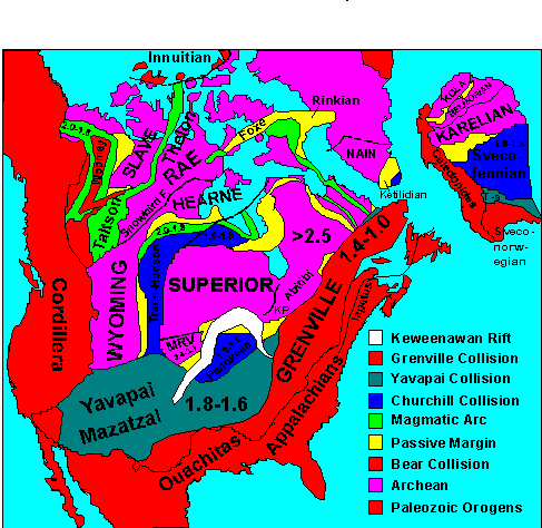
The
Sudbury region
is underlain by parts of three
structural
provinces: the Superior Province(> 2.5 Ga);
the Southern Province (1.86 Ga); and the
Grenville Province (1.0 Ga), and is therefore one of the
best places in the world to examine plate tectonic mechanisms of crustal
formation over a significant portion of Precambrian time. In addition, the
intersection of the three province boundaries at Sudbury marks the approximate
location of the well known Sudbury meteorite impact site and its associated
nickel-copper mineralization.
In terms of
crustal evolution, the greater
Sudbury region provides an opportunity to examine:
1) Archean-type crustal development as evidenced by the rocks of the Abitibi belt of the Superior Province.
2) the evolution of
the Southern Province through its various stages of
rifting,
volcanism and granite intrusion, large scale obduction-related?
deformation, collisional polyphase deformation and crustal melt formation, and
the genesis of important deposits of uranium and
silver.
3) major mafic dike swarms injected at 2.45
Ga, 2.22 Ga,
1.75?, 1.4?,
1.24 Ga, and 575 Ma.
4) the deformational and igneous character of the 'Grenville Front' as the northern limit of the c. 1.0 Ga collisional Grenville and the c. 1.75 Ga Penokean orogens.
The Sudbury region also provides an unique opportunity to examine the consequences of large-scale mining on the environment, and the efforts that have been made to curb the negative effects of this activity.
The geological significance of the greater Sudbury region is at least on a par with that of the Gros Morne Park region of Western Newfoundland, declared a World Heritage Site by the United Nations because of its geology. (The Gros Morne site is located within the obduction-related foreland land basin of the Appalachian structural province, and is considered "apparently one of the best places in the world to see the legacy of plate tectonics".) In comparison, the Sudbury region would need to be declared a World Heritage geological super-Site.
Why GIS/GPS?
Other than knowing how to make and record geological observations (by the end of third-year you should know how to measure dips and strikes; identify rock types, etc), it is important for a field geologist to a) know how to accurately record the coordinate locations of outcrops representing measurement and sample sites, and b) know how to archive and 'layer' the collected field data. Layering refers to the process of separating observed data into classes that can be viewed in different combinations, e.g. bedding orientations alone; bedding and foliations together; geologic boundaries and bedding trend lines; outcrop sites, etc. (In this sense ordinary geologic maps constitute a single layer, and as such contain far too much data to allow meaningful analysis of the individual data classes by simple visual examination of the map.)
Recording data
Locating yourself on an aerial photograph
Finding one's location on an aerial photograph when traversing in the bush is not easy. This situation can now be rectified through the use of a GPS unit in conjunction with a georegistered and usefully gridded airphoto. This aspect of field work will be taught prior to going to field camp. An outline of the course can be consulted at:
http://instruct.uwo.ca/earth-sci/350y-001/GPS_short_course.doc
A module describing the computer procedures used to georegistrer photographs is also available at the following internet site:
The module will also explain the concepts of map projection, rubber-banding, and data layering.
For a general course on GIS database concepts and mapping procedures click the following: 'Fieldlog'.
For a detailed explanation of image rectification see also:
http://www.eomonline.com/Common/currentissues/Apr02/cheng.htm
Student evaluation
Following the instructional stage (first four days), students will map for four days as individuals, and no further direct instruction will be provided during this part of the course. Nevertheless, for safety reasons, students will form mapping teams. (There are 25 students and two instructors, and the function of the 'instructors' at this stage will be safety surveillance and the correction of any serious locational problems - students walking off the limits of the airphoto, etc!!) Students will then carry out a practice test of their ability to map a relatively small area (the same area for all students), and finally a marked test of their mapping ability. There will also be an evening oral examination covering all aspects of the course that will simulate an interview for a job in the exploration industry. (The oral examination is a stressful examination for many students since this format makes it less easy for a person to fudge, avoid, or re-orient answers to questions. Nevertheless, it has the merit of replicating the common geology interview that students will inevitably face when entering the job market, and therefore provides an excellent opportunity to face this particular dragon. To be forewarned is to be forearmed!!) The overall evaluation will therefore be based on three components: the notes and maps (50%), the mapping test (40%), and the oral examination (10%).
Tentative Course schedule (last revised Jan 30th 2005):
Thu May 01 Travel to Sudbury (Grenville
marbles, anorthosites, gneisses; instructional day)
Fri May 02
The Impact story of the Sudbury Basin and surrounding areas (instructional
day)
Sat May 03
From the southern margin of the Sudbury basin to the Grenville Front (instructional day)
Sun May 04
Group mapping exercise (instructional day)
Mon May 05
Individual Mapping
Tue May 06
Individual
Mapping
Wed May 07 Practice
test
Thur May 08 Test
Fri May 09
Cutler granite
Sat May 10
Grenville Province
+ oral exam
Sun May 11
Return to London.
(It is possible that at least one day of the above schedule will be lost due to inclement weather)
En route to Sudbury a stop will be made between Parry Sound and Pointe
au Baril to examine the nature of the Parry Sound shear zone and the shear
pods of the southern Britt zone of the Grenville Province. Time permitting,
we will also examine the Alban quartzites and the high P/high T Burwash
migmatites.
The first two days of the course will involve a traverse of the Sudbury
basin to a point south of the ‘Grenville Front’ near Long Lake. (Geology
of the Sudbury Region.) The 9th day will
be dedicated to the geology of the Baldwin Anticline and the related Cutler
granite, and the 10th day with the geology of the northern Grenville Province. These
days, as well as the first day of travel, will be considered
instructional
days, and as such will provide students with an opportunity to test
their ability to recognise key rock types
and structures at the outcrop scale (Whitewater series, Sudbury Irruptive, ‘trap’ dikes, Nipissing diabase,
Sudbury diabase, Grenville diabase, high and low metamorphic grade Huronian
metasediments, ‘older’ and ‘younger’ Grenville Front granites, etc). They will also provide the context (big picture!) for an examination
of the various geophysical data sets (seismic, magnetic, gravity) currently
available for the Sudbury region.
We are fully cognizant that some students would like to be provided with more instruction than is given during the instructional days. However, given the limited time available to us (most US colleges require 6 weeks), and the need for students to have a opportunity to test themselves in the field before the summer field season - in other words to be weaned from total reliance on the instructors - we consider the 5 days of mapping to be minimal. In this context students should make sure that they participate actively and pay close attention to what is being said when instruction is given during the first four days! By the end of the field camp we would hope that you will have become decidedly more knowledgeable about the geology of Ontario and have learned to be observant, self-reliant, and confident in the field.
A comprehensive description of the geology to be examined during the course can be viewed at:
http://instruct.uwo.ca/earth-sci/200a-001/25sudbur.htm
The course is subject to student evaluation.
Travel-Accomodation-Meals
Travel to Sudbury
We
will travel to Sudbury in a bus, and since we are
25 students + 2 faculty + equipment, space will not be unlimited.
There will be room in the bus for two normal size 'soft' suitcase
per person (no guitars, drum sets, giant boomboxes, etc); please try
to minimize your luggage. If you wish to listen
to music while travelling, please bring your own head-set radios/cds.
The van radio will be turned on only at the discretion of the driver, and it would be appreciated that students not hassle the driver in this regard.
Students may travel to Sudbury in their own vehicles, but all travel during
the field camp period must be in the departmental vehicle.
Accomodation
IMPORTANT:
We have conducted field camp in the Sudbury region for many years.
We have been charged a very reasonable room rate
on the understanding that we do not damage property and do not disturb
other guests. This is very
important at a time when it is proving difficult to control the cost of
field camps. Consequently, we are obliged to comport ourselves in a manner
such that we draw no complaints from other residents or the local population. This means no noisy
parties, no drunkenness, no water bomb wars, no more than six people
in a room at any one time, no smoking, and rooms to be kept reasonably
tidy ('reasonable' to be determined by the residence staff).
Meals
The residence does not provide cooking utensils, and if you wish to use
the residence kitchen to prepare your own meals, including breakfast and lunch, you should
bring a small saucepan (e.g. for vegetables)/frying pan (e.g. for
meat) /bowl (e.g. for cereals)/aluminium foil (e.g. for fish)/plate/cup/ KFS/scrubber/dish cloth/drying
cloth/serviette. A visit will be made to a grocery store at the end of each day.
If many students choose to prepare their own meals, cooking may have to
be be done in 'sittings'. It would be polite in this case
to remove your garbage when finished and to keep the kitchen area
as clean as possible. Regrettably, other than under special circumstances, the rental van
will not be available "on demand" to provide a limousine service.
Morning
Departures
Departure time for the field each morning will be at 8.30 am prompt. Students
should therefore be showered by 7.30 am, have completed breakfast by
8.15
a.m., and be at the vans by 8.25 am.
Regulations
The University insists that SMOKING and DRINKING OF ALCOHOLIC BEVERAGES
NOT BE ALLOWED IN THE BUS OR VANS. Do not even bother to ask! Beverages
containing alcohol must be very securely packed away in your bags. Furthermore,
the University stipulates that "if students wish to consume alcoholic beverages it is to be done on their
own time and not any time during the course program."
University regulations also require that students wear hard hats and safety glasses when in the field, e.g. hard hats when examining unstable road sections, safety glasses when hammering rocks. Hard hats and safety glasses will be provided by the department.
Potential Problems
1)
The field course program is predicated on the assumption that the weather
will be constantly sunny. There is a chance however that some mapping days
will be lost to heavy rain. This is not the result of disorganization on
the part of the instructional staff!
2) This is a field course and students will need to adjust to being outdoors all day and having to walk long distances - sometimes in the cold, sometimes in the rain. We are willing to recognise that a student may discover at any given moment that they are not physically fitted for field work and/or that field studies are really not their "thing"! In this case it is important, particularly if the weather is poor, that an attempt be made not to diminish group morale. To this end, any complaint, legitimate or not, should be addressed promptly to Dr Osinski and not allowed to fester. We would prefer that field camp be a relatively pleasant experience, notwithstanding that it is an examination course and not a holiday.
3) Please try to limit the number of times you lock your key
in your room.
4) Please read the Ontario "Tresspass
to Property Act" at the following
government site:
http://192.75.156.68/DBLaws/Statutes/English/90t21_e.htm
If you wish to examine any outcrop that is
obviously on private property please request permission of the land owner
to examine the outcrop. Most, but not all, property owners are very
happy to let you examine rocks outcropping on their land. If you inadvertently
find yourself in a position of trespass and are requested to leave the
property, please provide an explanation of your presence to the landowner, and comply without protest if your explanation does not gain you permission
to remain. Be as pleasant and apologetic as possible, particularly
should the property owner show signs of irritation.
Equipment
The department will provide aerial photos, notebooks, compasses, GPS units, magnets, hammers, hard hats and safety glasses; for which the students will sign. (Although a deposit is not required for the use of the equipment, students will be required to replace lost or damaged equipment.)
Students should bring a WRIST-WATCH, HAND LENS, clipboard, and an ultrafine, waterproof, PERMANENT marking pen (Steadtler or Sharpie) capable of writing on mylar sheets and the aerial photos. Bring at least TWO markers of different colour - if you bring only one you will inevitably mislay or lose it within the first two or three days in the field!! (Bring three markers if you are the kind of person who mislays pens easily!) You are also required to bring pencils, ball-point pens, coloured pencils, ruler, square, two sets of spare AA batteries for the GPS units, sample bags, boots (perhaps also spare shoes/boots, running shoes, soccer shoes), warm clothing (+ thermos?), and rain clothes (ponchos).
IMPORTANT: you MUST,
MUST MUST! wear an outer shirt or field jacket, e.g. a
Brunton/crossing guard jacket, that is red or orange in colour
(NO greens, blues,
or blacks). This will increase
your visibility
and make it easy to find you should you get lost. Along with a
hard-hat, an orange jacket will mark you out, and cause you to invite less
attention from the public and sundry officials when wandering over outcrops.
Please also bring a sleeping bag or sheets and cover. The student residence does not provide bedding.
Bears
The field area you will be
working in is mostly open ground with minimal tree cover such that moving humans
and animals are easily seen from a distance. We have two Cobra MicroTalk2 units. Please feel free to
bring your own communicator, if it will make you feel more secure.
There is also a
likelihood (depending on the year) that you will see a black bear, wolf,
or coyote, and while in the vast majority of cases these animals will try
to avoid rather than approach you, there remains the possibility that a
bear will be attracted by 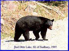 your lunch. Furthermore,
should you run into bear cubs, the bear sow could
be dangerous. The experts - see below - say no,
but you never know, for
which reason you should promptly remove yourself from the vicinity of the
cubs - don't hang around to take photographs! In consideration of these
eventualities, however unlikely, we will provide you with a spray deterrent if
you request it.
The following is taken from the web site of the Forest Service of the US
Department of Agriculture at:
your lunch. Furthermore,
should you run into bear cubs, the bear sow could
be dangerous. The experts - see below - say no,
but you never know, for
which reason you should promptly remove yourself from the vicinity of the
cubs - don't hang around to take photographs! In consideration of these
eventualities, however unlikely, we will provide you with a spray deterrent if
you request it.
The following is taken from the web site of the Forest Service of the US
Department of Agriculture at:
"Black bears can
injure or kill people, but they rarely do. When pressed, they usually retreat,
even with cubs. Attacking to defend cubs is more a grizzly bear trait.
(Grizzlies live only in Alaska, northern and western Canada, and the Rocky
Mountains south to Yellowstone.) Black bear mothers often leave their cubs
and flee from people, and those that remain are more likely to bluff-charge
than attack. Still, it is prudent to use extra caution
with family groups that allow close approaches because mothers are generally
more nervous than other bears. Nevertheless, chances of being attacked
around campsites by any black bear are small. During a 19-year study of
bear/camper encounters in the Boundary Waters Canoe Area Wilderness in
Minnesota, only two injuries were reported in 19 million visitor-days.
The study included the year 1985 when bear nuisance activity was at a record
high. The two injuries were by one bear on September 14 and 15, 1987. The
bear was killed the next day." "Unprovoked, predatory attacks by
black bears are rare but highly publicized. Such attacks have accounted
for all 23 deaths by non-captive black bears across North America this
century. Most occurred in remote areas where the bears had little or no
previous contact with people, rather than in and around established campsites.
The worst attack occurred in Ontario in 1978 when a black bear killed and
partially consumed three teenagers who were fishing. Predatory attacks
by black bears are usually done without bluster or warning. People involved
in such attacks can improve their chances by fighting rather than playing
dead. Deaths from such attacks average a little more than one every
four years across the United States and Canada." "Fortunately, black bears
usually use at least as much restraint with people as they do with each
other. Unlike domestic dogs, which often are territorial and aggressive
toward 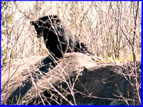 strangers, black bears typically behave
as the subordinate toward people when escape is possible." "Black bears
that want our food sometimes use threats or bluffs to get it, as has been
reported by campers, picnickers, and backpackers. The
most common behavior of this sort is blowing, which may be accompanied by
clacking teeth, lunging, laid back ears, slapping the ground or trees, and/or a
short rush. The same behavior is used to scare other bears from feeding areas.
The sounds and actions are all done explosively, with effective results.
However, it is rare for a black bear to attack a person during or after such a
demonstration. All blowing bears observed by the author retreated when pursued.
A less common sound is the resonant "voice" of a bear. This is used to express
intense emotions (fear, pain, and pleasure), including strong threats.
Black bears with ready escape routes seldom use this threat toward people.
Grunts are used in non-threatening communication to cubs, familiar bears, and
sometimes people."
strangers, black bears typically behave
as the subordinate toward people when escape is possible." "Black bears
that want our food sometimes use threats or bluffs to get it, as has been
reported by campers, picnickers, and backpackers. The
most common behavior of this sort is blowing, which may be accompanied by
clacking teeth, lunging, laid back ears, slapping the ground or trees, and/or a
short rush. The same behavior is used to scare other bears from feeding areas.
The sounds and actions are all done explosively, with effective results.
However, it is rare for a black bear to attack a person during or after such a
demonstration. All blowing bears observed by the author retreated when pursued.
A less common sound is the resonant "voice" of a bear. This is used to express
intense emotions (fear, pain, and pleasure), including strong threats.
Black bears with ready escape routes seldom use this threat toward people.
Grunts are used in non-threatening communication to cubs, familiar bears, and
sometimes people."
See also
http://www.bear.org/species/blackbear/bbslideshow/index.htm