This course allows students who have acquired some background in geographic spatial analysis and visualization techniques (cartography, remote sensing and/or GIS) to gain further experience in one or more of those areas while working on a full-term practical project. Note that this course will not introduce you to fields in which you have no background - you must take the appropriate 2000-level course to acquire that experience.
INSTRUCTOR: Dr. Philip J. Stooke, room 2425 SSC
Phone: 661-2111 ext. 85022
(NOTE: please do not leave voice messages on that number until further notice, if I do not reply, send an email)
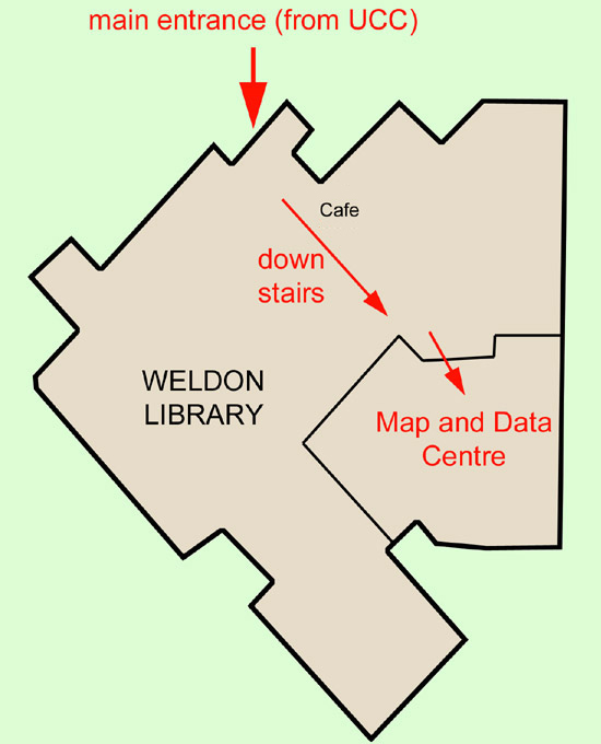
INSTRUCTOR OFFICE HOURS: Monday, Tuesday and Thursday, each day, 11:00 to 12:00 in the MAP AND DATA CENTRE, Weldon Library (LOCATION) , or by appointment, or just drop by my office any time (best days - Tuesday to Thursday). NOTE: Because those office hours are held in the Weldon Library, you cannot reach me on my office phone during those times.
e-mail: pjstooke@uwo.ca
website: publish.uwo.ca/~pjstooke
Return to Department of Geography
LECTURES (held in SSC 3014): Wednesdays, 12:30 - 2:30
LABS (held in SSC 1316A): Tuesdays, 1:30 - 3:30
PRINT CREDITS: Unfortunately the Department of Geography does not give out free print credits for this course. You may purchase print credits in 1316A (follow instructions on the notice board at the front of the lab), or print at Imprint, Books Plus or elsewhere. Remember - you can save an Inkscape file as a JPG or PNG image. That file can be printed on its own or (my advice) placed in a Word or Powerpoint file for printing.
EVALUATION:
The final mark is the sum of marks for three assignments and three brief class presentations. There is no examination. A systematic adjustment may be applied to these marks at the end of term. The breakdown is as follows: (due dates - see schedule)
Assignments:
1. Proposal: 25%
2. Proposal presentation 5%
3. Progress report: 20%
4. Progress presentation 5%
5. Project presentation 5%
6. Final Project: 40%
MARKING:
Marking of assignments in this course is based on ranking. All items handed in are considered together for each individual assignment. Typically, the majority will be reasonably well put together (well written, showing reasonable effort, well developed ideas, illustrations of design ideas or examples of work completed, etc.) A few will be less adequate (missing components, poor writing, apparently put together at the last minute, poorly developed ideas, below average progress on the project, no (or poor quality) sketches or examples of work to show progress, etc.). A few will stand out as exceptionally good (very well written, above average progress, clear signs of extra effort beyond what was asked for, fully developed ideas, good quality illustrations of design plans or work completed, etc.). The large middle group will receive marks in the B range (mid-70-percent range). The lower group, if any, will receive marks in the C range, and the higher group will receive marks in the A range. Since assignments vary in nature, expectations vary between them, but this basic pattern applies to all of them.
The final mark distribution for this course will be adjusted if necessary to give a class average in the 'B' range, approximately 75%. Marks in the A range, 80% or higher, will be limited to students significantly above the average level of achievement.
PREREQUISITES:
It is the student's responsibility to ensure that prerequisite courses have been passed prior to registration in this course. Students without the necessary prerequisites for this course must request special permission from the instructor to take the course, and this will usually be granted to non-Geography students.
Regulation:
"Unless you have either the requisites for this course or written special permission from your Dean to enroll in it, you may be removed from this course and it will be deleted from your record. This decision may not be appealed. You will receive no adjustment to your fees in the event that you are dropped from a course for failing to have the necessary prerequisites.”
http://www.uwo.ca/univsec/pdf/academic_policies/appeals/scholastic_discipline_undergrad.pdf
All work you hand in must be your own. You may seek advice from other students regarding design, techniques or software operations, but you must not share or duplicate map files, including base maps. This includes finding another student's saved file on a computer, making minor modifications, and passing the work off as your own. Any offence will trigger the procedure outlined on the linked document.
SUPPORT SERVICES FOR STUDENTS:
Registrar's Services
Student Development Services
Accommodation for medical illness:
(PDF file)
Students who are in emotional/mental distress should refer to mentalhealth@western for a complete list of options about how to obtain help.
Cartography:
1. Large sheet map (e.g. tourist facilities of downtown Toronto, recreation map of the Bruce Peninsula; archeological sites of the Stonehenge region, photomosaic of an Ontario County; record of personal travel (past or anticipated), Mars landing sites).
2. Atlas (e.g. Evolution of downtown London, 1840-1990; Canadian university campuses; Tourist atlas of (you name it); Battlefields of the War of 1812; Air photo atlas of Essex County; Atlas of 20th Century U.S. hurricanes; Natural disasters in British Columbia Since 1900). An atlas could also be presented on screen as a PDF file or Powerpoint presentation rather than on paper.
3. Artistic map. NOTE: Some maps today are designed to be artistic rather than technical in appearance - for instance, tourist maps with photographs or drawings and text pasted onto a schematic or sketch map, or maps illustrating travel articles or works of fiction (e.g. Lord of the Rings). If you pick a suitable topic you can create a map like this by hand rather than on a computer. Some maps used for education or public display might be made as 3D models. You could make a map like that, but what you hand in at the end of term should be a series of photographs of it, not the model itself.
HTML project:
A map project presented as an HTML (World Wide Web) document, i.e. a map-based website. Note that the emphasis is on maps... this is a cartography course. Past projects have sometimes been too heavily concerned with non-map content, but I emphasize here that you must concentrate on creating your own maps for this type of project, and text, photos etc. should be subsidiary to the map content.
Remote Sensing/GIS:
1. Creating a multi-layer data set:
Select an area, find suitable data sets, convert to format for your choice of software, register everything (examples: air or space photography; topography, land use, zoning, geology etc. data for a region: collect or create the layers and register them to form a GIS database).
2. Analyzing a data set: smaller version of (1) above, used to try to solve a realistic problem.