Click here to go to 'Figures/Overheads' section.
RETURN TO:
Click here to return to course outline.
Geographic Information Systems and Fieldlog
A Geographic Information System is a computer-assisted system for the acquisition, storage, analysis, and display of spatially referenced data, and involves four operations:
Data Collection
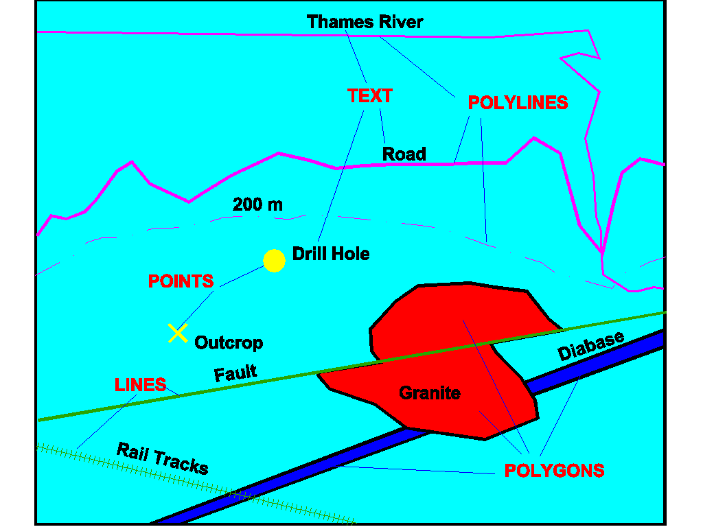
WHAT IS 'VECTOR DATA'?
Vector objects are represented on two-dimensional maps by any or all of the following drawing elements: 1) points, e.g. survey points, outcrops. 2) straight lines, e.g. a township boundary, some roads, pylon lines. 3) polylines, e.g. rivers, roads, contours, geologic boundaries, faults; strike trends. 4) polygons (areas), e.g. granite bodies, geographic contours, structure contours. 5) text.
Such elements
are vector quantities, and as such are defined
by a set of coordinate points (nodes
and vertices) marking the beginning and end of the lines that make
up the element set - one x,y coordinate in
the case of a point, two in the case of a straight line, one plus the number
of lines in a polyline, and a number equivalent to the number of lines
in a polygon (the beginning and end points have the same coordinate location).
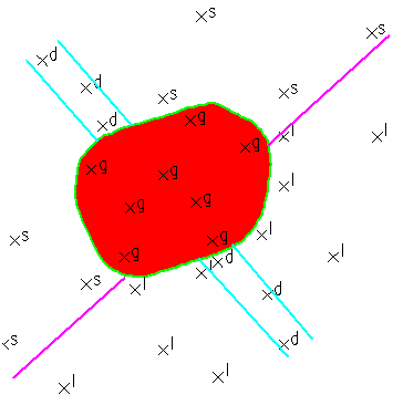
Geological observations made at point sites (stations)
representing outcrops (lithologic or structural data) or sampling locations
(soil samples) are known as the geological attribute
data of the location. The data can
be sorted, selected, and plotted by the GIS analyst - who may or may not
be the same person who collected the data - according to stipulated criteria
(e.g.all granites located within Cardiff Township that have high K-felspar
contents, and for which chip samples are available for radon gas analysis).
Furthermore the selected data can be exported as DXF
plot files and then imported into drawing programs such as AutoCAD, Generic
CADD, Design CAD, Easy CAD, RtiCAD, Corel Draw, ARC/INFO GIS, SPANS GIS,
Windows Word, IDRISI, PCI, ERMAPPER, SAGE, etc. The point image can then
be used as the basis for generating other vector line and polygon
drawing elements such as faults and lithologic boundaries.
WHAT IS 'RASTER DATA'?
In contrast to vector systems, data in raster
format is represented by a system of numeric values (e.g. granite = 5 =
red; diabase = 4 = blue; no outcrop = 0 = white) that are attached to an
orthogonal grid of rectangular cells, such that the map appears as a matrix
of coloured rectangles (cells). The actual appearance of the image depends
on the size (resolution) of the cells making up the grid. Scanned aerial
or landsat photographs are raster images,
as are interpolated magnetic and gravity
data maps. Because each point on a raster image is represented by a numerical
integer value, different types of raster images can be combined by algebraic
means, e.g. one could generate a map showing the distribution of the ratio
of gravity to magnetic values. Vector and raster images can also be converted
one to the other, using computer software such as IDRISI, PCI, ERMAPPER,
etc. For example, a geological map showing the distribution of granite
as a set of vector polygons can be converted to a raster image by setting
all cells located within the polygonal areas of the granite to some integer
value, and all cell locations outside of the polygons to some other integer
value.
Raster images may be overlain by Vector images,
and scanned raster images of aerial photographs or satellite images (LANDSAT,
RADARSAT) are commonly used as a `backdrop'
on which point vector data are projected or geological boundaries (vector
entities) drawn.
The creation of a raster image from point values
of numerical data requires the use of a statistical `interpolation'
routine.
.
HOW IS THE
DATA STORED AND MANAGED - FIELDLOG
Fieldlog is a database
developed by Boyan Brodaric of the Geological Survey of Canada for the
digital storage of geological data of any kind pertaining to a specific
locality - usually an outcrop in the case of a mapping database. It is
a relational database (similar to dBASE) which
stores attribute data in the form of Tables, Records,
and Fields. A Table is similar to a
spreadsheet composed of records (rows) and fields (columns) containing
information of different classes - there might be a table for structural
data, one for geochemical data, one for data referring to the collection
locality, etc. The tables are linked (related)
by having each of them contain a common item of information, usually an
outcrop number or STATION NUMBER (STATIONUM).
This item or 'field' appears in all the tables.
Records contain information about specific samples or measurements (from
the same or different outcrops), and the fields of the record contain a
single item of information about the sample, e.g. its name, or lithology,
or thin section # or angle of dip, etc.
The number of tables and their contents (fields) are
project dependant. Fieldlog will accept up to 15 tables and 27 fields in
each table. A typical geological project might contain tables
for STATIon information, STRUCtural observations, SAMPLe and PHOTOgraph
recordings. Each of these tables, in turn, will contain fields
to store the data within the tables; eg. the STRUCtural table might contain
the following fields: type of structural reading, strike, dip. Each field
occupies a fixed space measured in number of characters, and a data type
such as numeric or text. A project definition is created by providing these
parameters to Fieldlog through filling the definition form which appears
as the initial screen. Each row in the form contains the information for
a specific field, including the table in which it resides, its size and
type, and some plotting characteristics.
Table and field structure of a Fieldlog database Table Fieldname Type Digits Decimal Enter as Aut. Perm. N S Layer Places Default Pmpt Val. STATI STATIONUM TEXT 11 0 N Statnum N Y STNO LOCATION PNT 8 0 N Location Outcrop N N LOCATN LOCODE TEXT 1 0 Y Locode x * + - o Y N OUTCRP WHERE MEMO 80 0 N Where Y N WHEN DATE 80 0 Y When Y N AIRPHOTO TEXT 15 0 Y Airphoto Y N NTS TEXT 6 0 Y NTS Y N UNIT TEXT 10 0 N Unit A B C D Y Y ECHO COMMENT MEMO 80 0 N Comt STRUC READING SYM 6 0 N Reading BED FOL Y Y STRUC AZIMUTH INT 3 0 N Azimuth Y N STRUC DIPLUNGE INT 2 0 N Diplunge Y Y STRUC GROUP TEXT 1 0 N Group a b c d SAMPL SAMPLNUM TEXT 6 0 N Samnum Y N SAMPL LITHCODE TEXT 1 0 N Lithcode Y N SAMPL MISCNUM REAL 6 2 N Miscnum Y N SAMPL POLNUM TEXT 8 0 N Polnum Y N SAMPL THINNUM TEXT 8 0 N Thinnum Y N SAMPL ROCKTYPE TEXT 20 0 N Rocktyp SSTNE ETC Y N SAMPL METALS TEXT 11 0 N Metals AU AG ETC Y N SAMPL THINSECT ISTR 20 0 N Thinsect PLAG ETC Y N SAMPL REMARKS MEMO 80 0 N Remarks PHOTO ROLL TEXT 6 0 Y Roll FRAME INT 2 0 N Frame REASON TEXT 20 0 N Reason MIN SAMPLNUM TEXT 6 0 N Samnum Y N MIN PLAG RSTR 10 0 N Plag SIO2 TIO2 ETC Y N MIN ETC RSTR 10 0 N MAJ SAMPLNUM TEXT 6 0 N Samnum Y N MAJ SIO2 REAL 5 2 N SiO2 Y N MAJ ETC REAL 5 2 N TRA SAMPLENUM TEXT 8 0 N Samnum Y N TRA CR REAL 6 2 N Cr Y N TRA ETCNOTES: INT - integer; REAL - number with decimal places; ISTR - string of integers or X, Y, and N.; RSTR - string of reals (to 99.99) or X, Y, and N; SYM - names plotted as symbols contained in a symbol library, e.g. NATMAP; MEMO - text field of flexible length; PNT - an XYZ coordinate NTS - National Topographic Survey map sheet reference.
Location coordinates can be entered as UTM (Universal Transverse Mercator; 7 characters; default is the 1927 North American Datum), or Lat-Longs (10 characters, five decimals) or a user defined grid (8 characters). The length of a real field involving decimals must include space for the decimal point.
When 'ECHO' is entered in the layer column, the contents of the field are entered on a layer with the same name as the keyword used in the field. For example, all samples whose lithology is entered as the keyword granite will be plotted on a 'granite' layer.
The 'GROUP' field in the STRUC table allows structural data such as coeval foliations and lineations to be treated as a group. For example a foliation and lineation developed during F1 deformation may be grouped as group A related data; foliation and lineation developed during F2 as group B, etc.
(The 'Prompt', 'N (Null Entry)', S (Display)', and 'Layer' refer to functions available when entering data in Autocad and will not be used in this course. The 'Prompt' function is presently not available. If the 'Null Entry' function is designated as 'Y', it indicates that a field may remain empty during data entry from within Autocad. If the 'Display' function is indicated as 'Y', the data being entered into the field will be displayed on the map generated during interactive data entry within Autocad.)
In the lab demonstration of a GIS system, we will assume that data has already been collected and stored electronically as a computer text file. The data will then be imported into Fieldlog, sorted and selected, and re-exported as a dxf file. The latter file will then be used to generate a point vector map showing the distribution of various rock types. The student will then interpret the data to generate a geological map using the drawing program CorelDraw.
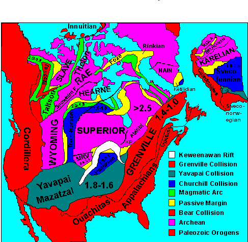
Structural Provinces of North America.
RETURN TO: