Click here to return to course outline.
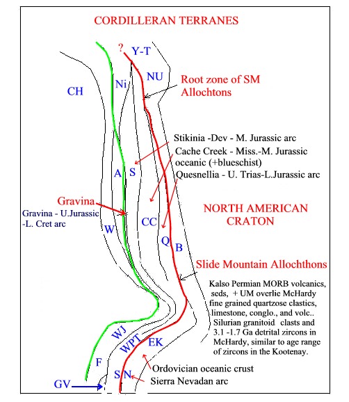
The Cordilleran
System forms a c. 500 km wide 'collage'
of oceanic, arc and continental margin tectono-stratigraphic terranes
accreted during the Phanerozoic to the western margin
of continental North America. Each terrane is a fault bounded entity of
regional extent characterized by an internally homogeneous stratigraphy
and geologic history that is different from that of contiguous terranes.
Terranes that are potentially
far traveled from their sites of origin are called 'suspect'
terranes, whereas those that are clearly related to the continental margin
against which they presently sit are called 'native'
terranes.
Suspect Terranes of the Cordilleran Orogenic
System
Simplified terrane map of the Cordilleran system.
The welding of terranes to a continental mass is known as 'accretion', whereas the assembling of terranes to form composite units prior to accretion is known as 'amalgamation'. These processes take place along continental margins without the intervention of continent - continent collision. Limits on the timing of amalgamation or accretion may be provided by the age of plutonic bodies that cut the suture boundary between the terranes ('stitching plutons'), the age of overlapping strata present in both terranes, or the age of shared metamorphic-deformation events. Sedimentary basins that cross terrane boundaries are commonly called 'successor basins'.
The Southern Cordillera of
California and the Klamath Mountains
Southern
California is composed of three tectonic elements:
a) the Franciscan
blueschist melange + ophiolite;
b) the Great
Valley sedimentary sequence, proximal and distal (Toro
Formation);
c) The Sierra
Nevada batholith.
Generalized
geological map of Southern California
Section
illustrating the geology of southern California during the Jurrassic
Geology
of the Franciscan at San Luis Obispo, Page (1972)
Tectonic
models for the development of the Franciscan, Constenius et al., (2000,
Fig 1)
These three tectonic
elements represent a Jurassic - Cretaceous arc system in which the Sierra
Nevada and Great Valley represent an arc/fore-arc basin couple,
and the Franciscan a subduction
zone melange of oceanic crust and regurgitated
blueschist material brought back to the surface from depths of about
30 km. Terrane boundaries dip eastwards such that accretion
was promoted by underthrusting of the Franciscan beneath the Great
Valley sequence.
The accretionary history
of the Klamath region of northern California
and Oregon extends back to early Paleozoic
time, and involves four phases of accretion, all associated with easterly
underthrusting of arc systems beneath the continental margin. The
most easterly terrane, the Eastern
Klamaths, is composed of Late
-Silurian - Early Devonian
(431-398 Ma, zircon)oceanic crust and arc material, structurally underlain
by high grade amphibolitic rocks representing a dynamothermally metamorphosed
sheet of subducted oceanic crust. Lower Devonian volcanic rocks (Redding
Fm) overlying the Trinity ophiolite were coeval with mafic complexes associated
with the ophiolite. The ophiolite was formed above an easterly dipping
subduction zone. Siluro-Devonian volcaniclastic, melange and quartzofeldspathic
metasedimentary rocks of the Yreka terran structurally overlying the Trinity
complex. The sediments have sources both in arc and continental material.
The Trinity Eureka rocks are correlated with the Shoofly complex of the
Sierra Nevada. Maturation of the arc was completed by the Late Devonian,
and predates the Early Mississippian Antler orogeny.
To the west the Ordovician
rocks are underthrust by a unit of blueschist-bearing
rocks (Stuart Fork Formation) metamorphosed and accreted during the Triassic.
Further west again, the Western Paleozoic
and Triassic belt is composed largely of arc and melange
units containing Permian age Tethyan fusulinid
fossils. Accretion of these terranes to North America was complete by Mid-Jurassic
time, prior to the intrusion of the early mid-Jurassic (c. 174 Ma) 'stitching'
plutons intrusive into all the terranes.
Generalized tectonostratigraphic map of
the Southern Cordillera, Ingersoll, (1986)
Map of the Klamath Mountains region, Irwin,
(1972) - map1
Map of the North Fork, Hayfork and Rattlesnake
Creek terranes, Irwin (1972) - map2
Genralized map of the Klamath Mountains
region, Snoke (1977)
Age and Fauna types within the Paleozoic Triassic
terranes of the Klamath Mountains, Gray (1986)
Recent Geological Time Chart for the
Paleozoic, GSC 1999
Correlation chart of terranes in the Klamath
Mountains, Gray (1986)
Photo of melange in the North Fork Terrane,
Klamath Mountains, Irwin & Jones (1977, Fig. 2)
Plate tectonic history of the Klamath
Mountains, Ernst (1999)
The youngest accreted terrane is known as the Western Jurassic belt. It is composed of younger Jurassic oceanic rocks (Josephine, Rogue-Galice), accreted during the latest Jurassic, and is roughly equivalent to the Coast Range ophiolites and arc rocks of California, and the Smartville ophiolite and associated arc of the Western margin of the Sierra Nevada.
Model for the Rogue-Galice, Snoke (1977)
Snoke (1977) represents the Rogue-Galice sediments
as having been deposited in a back-arc basin. However they may have been
rather deposited in a fore-arc basin above a westerly dipping subdcution
zone.
Large scale map and comparative Late Jurassic
tectonic history of the Coast Range, Sierra Nevada, and Klamath Mountains,
Ingersoll (1986)
Tectonostratigraphic Map of the Southern
Cordillera, Ingersoll, (1986)
Paleogeographic evolution of the West
Coast of the USA during the Late Jurassic, Ingersoll (1986)
Most recent publication:
Soreghan, M.J. and Gehrels, G.E., 2000. Paleozoic
and Triassic Paleogeography and Tectonics of Western Nevada and Northern
California. GEological Society of America SPE347, 256 p.
Metcalf, R.V. and Wallin, E.T., 2000, Mid-Paleozoic
development of the Klamath-Sierra Forearc-arc-backarc subduction system,
Northern California. GSA Abstr., Reno, p. A-497.
In the case of the Klamaths,
Southern California and the Sierra Nevada, it is clear that the mass
of continental North America has been increased since early Phanerozoic
times by the simple sequential accretionary underthrusting of ocean crust
and related arc systems.
FIGURES
Structural Provinces of North America.
Simplified terrane map of the Cordilleran system.
RETURN TO:
Click here to return to beginning.