Click here to return to course outline.
NEW - Was the Earth cooler than we think it was 4.4 billion years ago OR click here
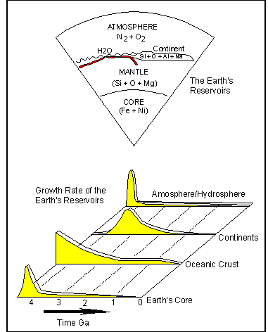
Archean rocks are an important source of information concerning the early evolution of the Earth, and the development of the Earth's four main reservoirs (click - 15cntgrw.gif). They are found within all continents (click - seisdurr1.jpg), but the largest single belt of Archean is represented by the Superior Province of the Canadian Shield, and the oldest rocks in the world, the Acasta gneisses, are located in the Canadian Slave Province.
Key review references:
Armstrong, R.L. 1991. The persistent myth of crustal growth. Australian Jour. Earth Sci., 38, p. 613-630.
Bowring, S.A. and Housh, T. 1995. The Earth's Early Evolution. Science, 269, p. 1535-1540.
Davies, G.F. 1997. The mantle dynamical repertoire: plates, plumes, overturns and tectonic evolution, AGSO Jour. Australian Geology and Geoph., 17, p. 93-99.
Taylor, S.R. and McLennan, S.M. 1997. The origin and evolution of the Earth's continental crust. AGSO Jour. Australian Geology and Geoph., 17, p. 55-62.
The
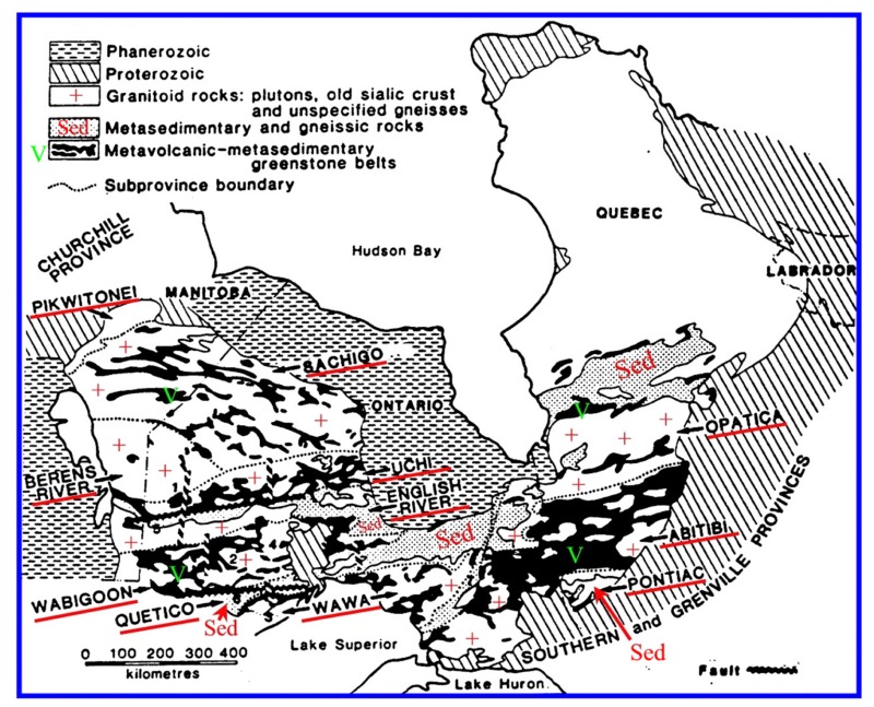
Superior Province
The c. 3000-2700
Ma Archean age Superior Structural Province is made up of east-west
trending paired belts of northerly volcanic
and southerly sedimentary sub-provinces [e.g. Uchi-English
river; Wapigoon-Quetico/Nemiscau (Opinaca), Wawa/Opatica/Abitibi-Pontiac],
within which (Opatica/Wawa; Winnipeg
River) and beyond to the north (Berens)
occur irregular belts of tonalitic gneisses with 'floating' 'keels'
of metavolcanic rock. In general the pluton-dominated gneiss belts structurally
underlie the low grade volcanic/sedimentary belts, and are thought to represent
exhumed middle/lower crustal levels of the Archean craton. Locally,
lower crustal high grade (granulite) gneisses are up-faulted as linear
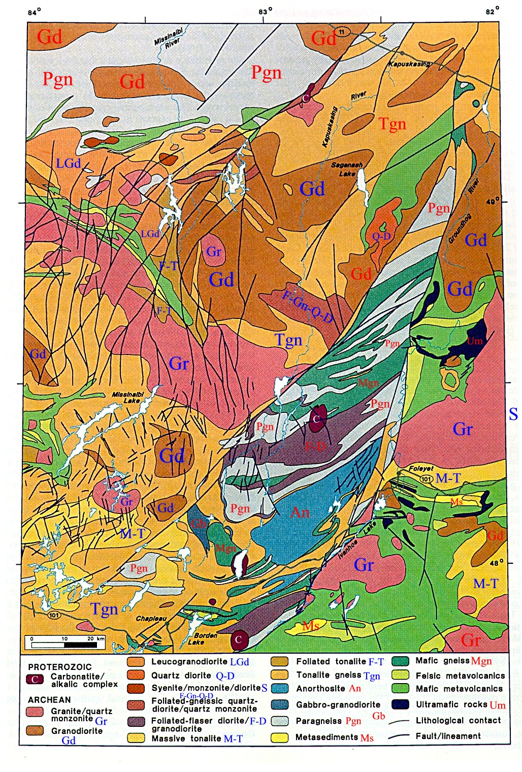
domains within the gneiss/volcanic belts (e.g. Kapuskasing)
The
Superior Province of Canada I - arch2sup1.jpg
The
Superior Province of Canada II - arch2sup2.jpg
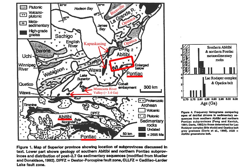
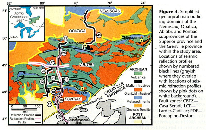
Subprovinces
of the Abitibi Province and location of LIthoprobe seismic reflection and
refraction profiles - arch1abit1.jpg
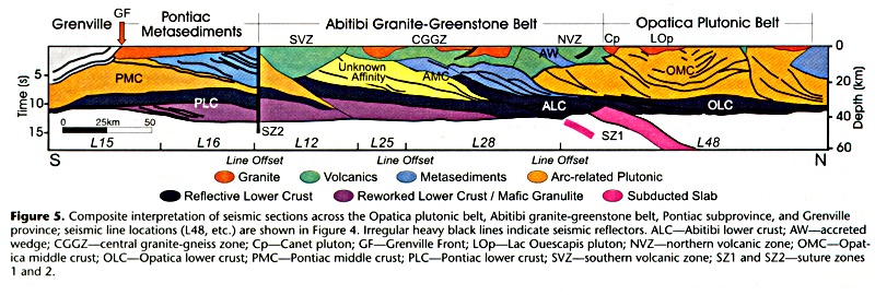
Seismic
interpretation of the structure of the Abitibi Province - arch1abit2.jpg
Map
of the Kapuskasing structural 'High' (lower Archean plate) - archkapus1.jpg
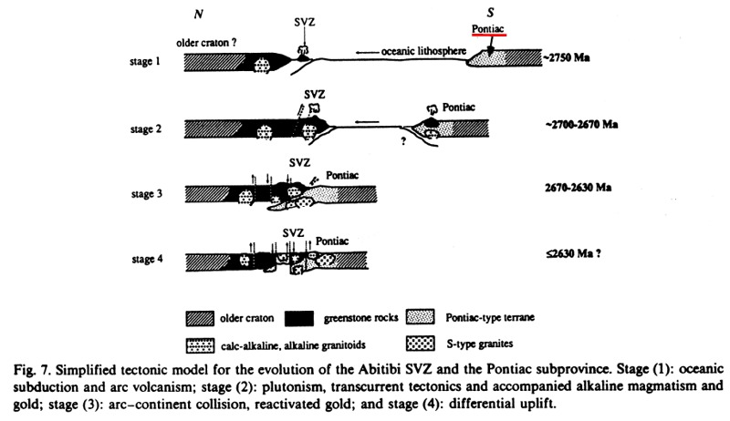
Simple
plate tectonic model for the evolution of the Abitibi belt of the Superior
Province - arch2sup3.jpg
Although no mantle-bearing
ophiolite or arc units have been recognised in the Archean, ultramafic
rocks are nevertheless ubiquitously present in the form of magmatic flow
rocks known as komatiite.
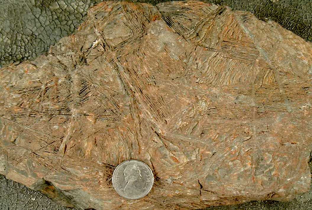
The upper parts of the flows are characterised by the presence of olivine
or, more rarely, clinopyroxene, in the form of coarse, platey, sheaf-like
aggregates that propagate downwards from the upper surface of the flow.
The aggregates resemble Australian spinifex grass, and the olivine is therefore
said to be spinifex textured. The presence
of ultramafic liquids in Archean volcanic sequences is used as evidence
that geothermal gradients were higher during the
Archean than at present, and that the mantle was subjected to relatively
high degrees of melting at this time - although possibly with as much as
4 wt.% water (Parman et al., 1997). Archean volcanic sequences are important
sources of Ni, Cu, Zn, Fe, and Au, but not tin.
Rocks of the
Abitibi sub-province of the southern Superior province are very well preserved,
and little exhumed. Along its southern margin the Abitibi volcanics are
overlain by belt of turbiditic sediments that pass from proximal to distal
from north to south. The source of the sediments, and particularly the
2900-2800 Ma detrital zircons found in the Pontiac, likely lies to the
north within the exhumed Opatica gneiss belt.
The
Superior Province of Canada, zircons - arch2sup2.jpg
The boundary zone of the volcanic and sedimentary sequences is also the locus of deposition of shallow water coarse conglomerate, cross bedded sandstones, and K-feldspar rich alkali syenites (shoshonites), granites and rhyolites. The boundary zone is an important site of deposition of hydrothermal gold at c. 2693 Ma.
Within
the belts dominated by plutonic rocks, Archean supracrustal sequences are
commonly preserved as relict 'mafic keels' within a sea of granitoid intrusive
rocks of the 'Tonalite-Tronhdjemite-Granodiorite' suite.
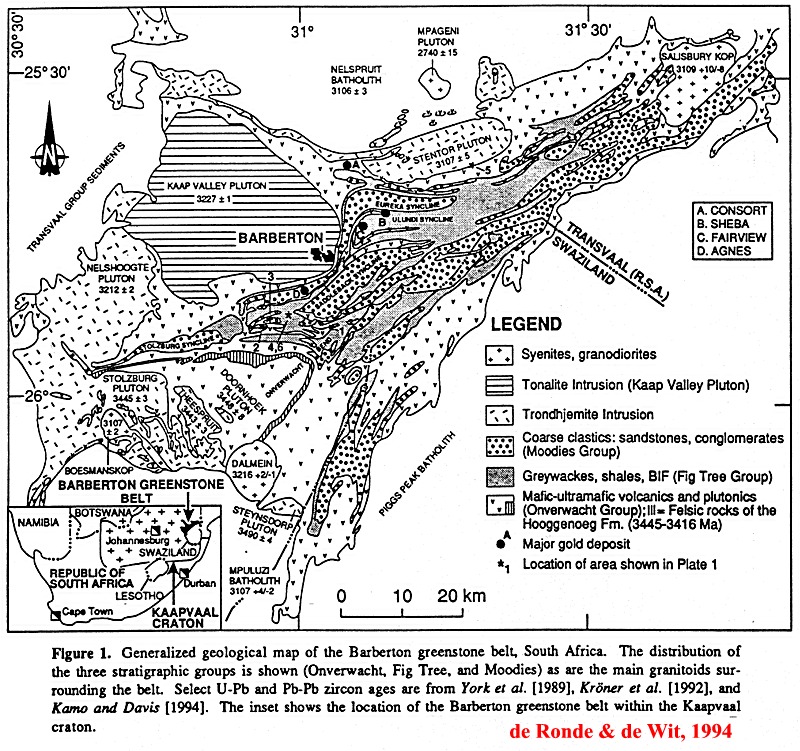
In the type
area for this mode of occurrence, the Barberton
Mountain Land (click) granite-greenstone
terrane of South Africa is composed of small wedges of tonalitic gneiss
(Theespruit gneiss, 3538 Ma), komatiitic, mafic and felsic volcanics (Onverwacht
Group, 3472 - 3416 Ma) injected by 3352 Ma old gabbro and diabase (rifting),
a middle sequence of greywackes, cherts, and ignimbritic volcanic rocks
(Fig Tree Group), and an upper sequence of shallow marine to subaerial
quartzose sediments. One Archean model suggests that the Onvervacht represents
Archean ocean crust obducted onto the Theespruit gneiss as continental
crust. The main phase thrust and recumbent fold deformation of the Barberton
Mountain Land was a very rapid event, initiated during the later stages
of deposition of the Fig Tree Group and coeval with upper Fig Tree ignimbritic
volcanism at 3227 Ma. The deformation was followed by the very rapid deposition
of the molasse-like Moodies Group. The latest stage in the Archean evolution
of the Barberton Mountain Land involved formation of upright Archean folds
and extensive intrusion of potassic granites at c. 3105 Ma.
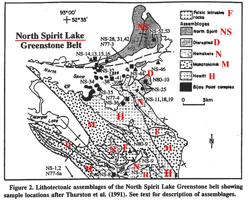
In Canada a
representative example of a relict greenstone keel would be the c. 3023
- 2900 Ma North
Spirit Lake (click) greenstone belt of the
northern Superior Province (Sachigo sub-province). This belt is unusual
however in that the mature quartz-arenitic Nemakwis
assemblage - analogous to the Moodies of South Africa - overlying
the basal ultramafic-mafic-felsic volcanic sequence is
overlain by younger spinifex textured komatiite flows. This unit
is followed in turn by coarse alluvial sediments and c. 2735 Ma-old mafic-felsic
volcanic rocks and associated turbidites. As in the Abitibi belt, the
youngest assemblage at North Spirit Lake includes shoshonitic rocks and
course fluvial sediments.
Where the Archean
crust has been tilted and/or uplifted, as in the case of the Kapuskasing
belt of Ontario, it can be observed that the low grade volcanic and sedimentary
rocks are separated from the high grade mafic rocks by extensive areas
of tonalitic gneiss.
Map
of the Kapuskasing 'High' - archkapus1.jpg
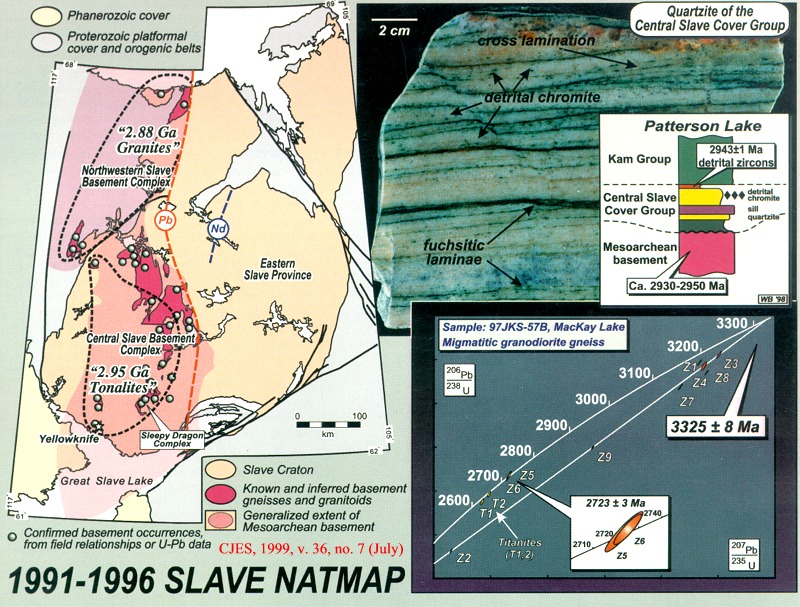
The oldest zircons found in the Archean are 4300 Ma detrital zircons in Archean rocks of Western Australia (but see). However the 4000 Ma zircons from the Acasta gneisses (tonalitic, amphibolitic and granitic gneiss protoliths) of the Slave Province are the oldest zircons from mappable intact terrestrial rocks. The gneisses form the basement on which were deposited 2810 to 2600 Ma old volcanic and sedimentary rocks. Deposition of c. 2600 ma turbidite and conglomerate sequences across the entire Slave Province was synchronous with or closely followed by regional deformation, metamorphism, and plutonism between 2600 and 2580 Ma. The existence of even older crust in the Slave Province is indicated by the widespread presence of older cores in the zircons of even the oldest rocks, and epsilon Nd values as low as -7 resulting from the mixing of mantle-derived melts and crustal magma produced by the melting of pre-existing amphibolitic mafic and tonalitic crust. (See below)
NATMAP
Slave Province Project, Canadian Journal of Earth Sciences, v. 36, no.
7 (July) - slavenatmap1.jpg
Map
of the Slave Province - slavecolmap.jpg
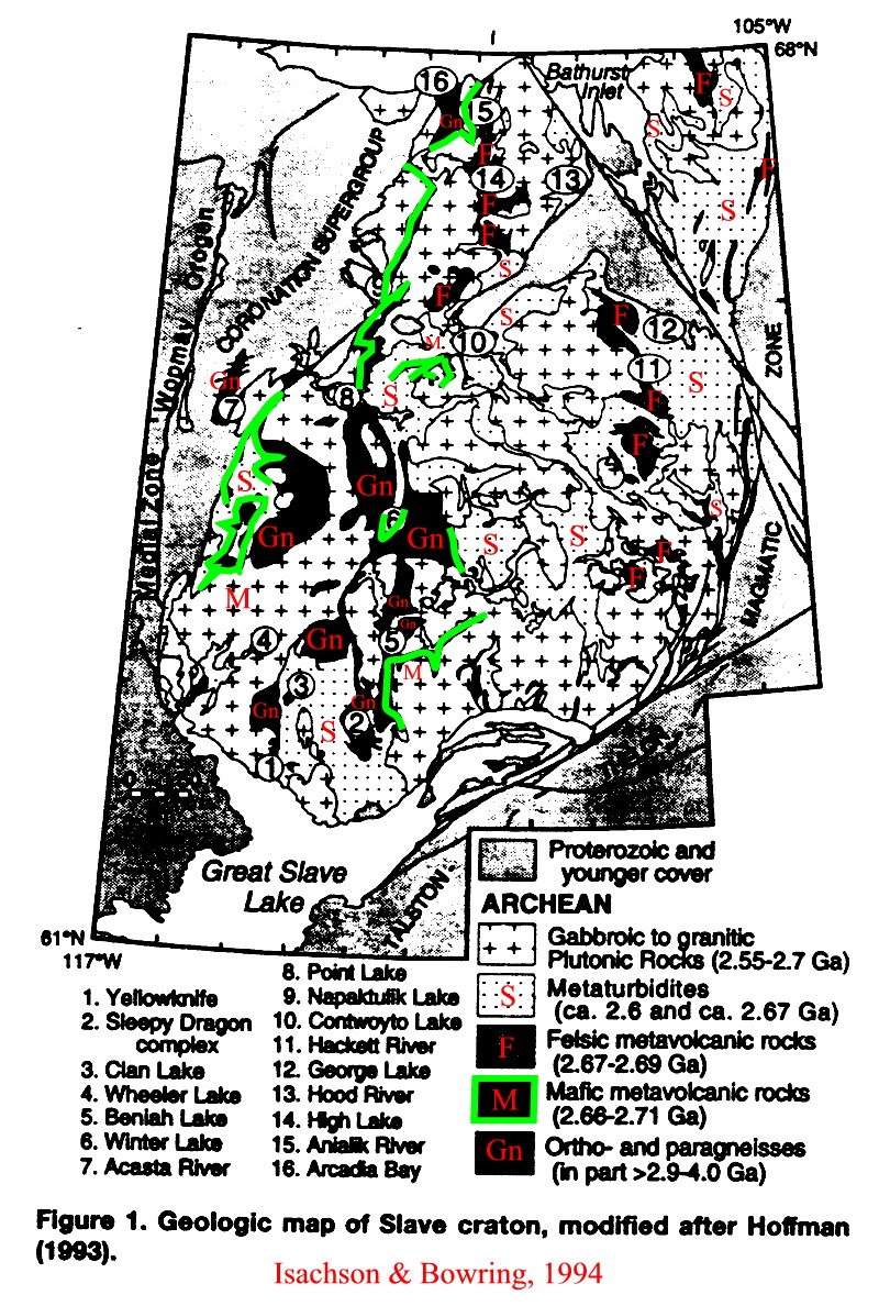
Map
of the Slave Province according to Isachson and Bowring, 1997 - slaveisach.jpg
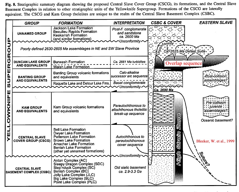
Stratigraphic
summary diagram for the Central Slave Cover Group - slavestrat1.jpg
Time-space
chart for the Northwestern Slave basement complex - slavetecthist2.jpg
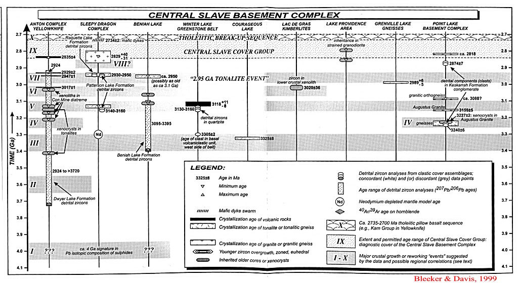
Time-space
chart for the Central Slave basement complex - slavetecthist3.jpg
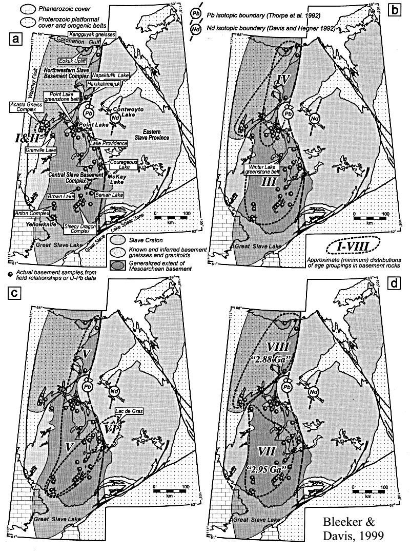
Maps
showing regional distribution of events detailed in the Time-space charts
- slavetecthistmaps
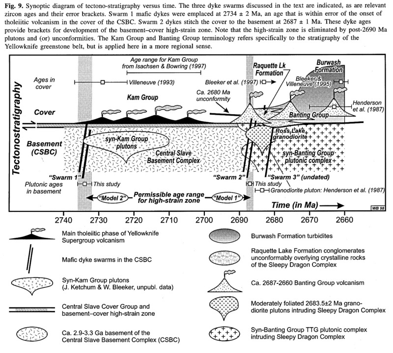
Diagram
illustrating the Tectono-statigraphic development of the Slave Province
with time - slavetecthist1.jpg
Is the subcontinental lithosphere beneath Archean terranes different from that beneath Proterozoic terranes?
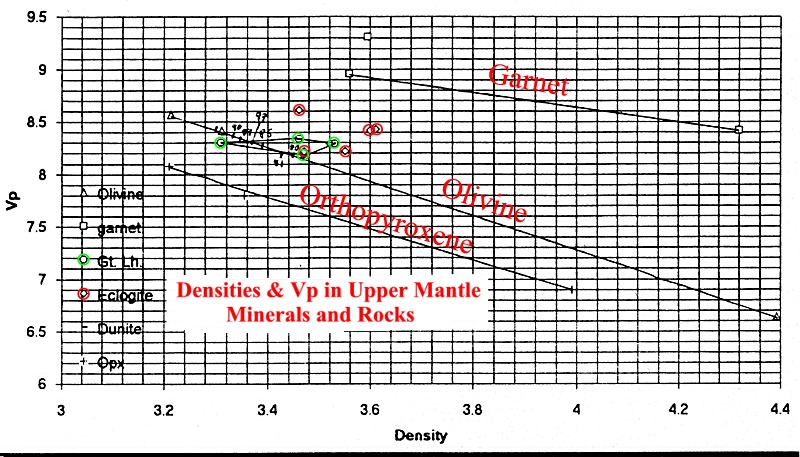
P-wave
velocities in mantle minerals are inversely proportional to the density
of minerals of the same family - more correctly P-wave velocities are related
to the rigidity characteristics of minerals, and Forsterite has a high
velocity than Fayalite even though Forsterite is less dense than Fayalite.
However, between mineral species, P-wave velocities increase with
density from quartz to feldspar to pyroxenes to olivine to garnet.
Density
versus Vp, upper mantle minerals and rocks - seismantvp.jpg
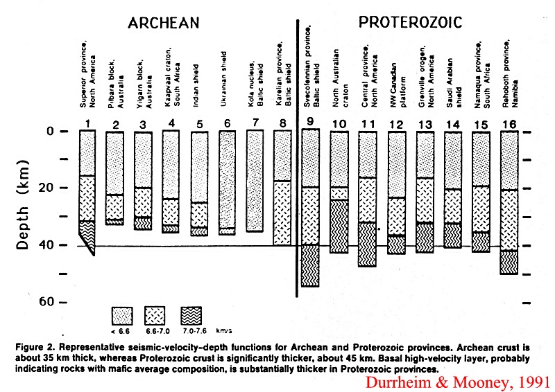
On the assumption
that the base of the crust is located at the depth at which the seismic
velocity exceeds 7.6 km/s, it would seem, with the exception of Canada,
that the Crust of Archean provinces is relatively thin compared to Phanerozoic
provinces. In explanation (Durrheim and Mooney, 1991) it has been proposed
that the material for the formation of Archean crust
was derived directly from the mantle beneath the Archean crust, which is
therefore relatively depleted in crust forming elements, whereas Proterozoic
crust was formed by normal plate tectonic subduction-related processes
involving lateral transfer of material AND the addition of basaltic material
by the process of underplating. On the other hand Sr isotopic data
suggests that the lithosphere beneath the Superior Province is relatively
enriched in incompatible elements such as Rb. The metasomatic or intrusive
addition of a garnet component to the mantle lithosphere (eclogite) would
tend to maximize the P-wave velocity of the Archean tectosphere.
Model
crustal thicknesses for Archean and Proterozoic provinces - seisdurr2.jpg
GSA Abst 2000
Mooney, W.D. and Artemieva,
I. Thermal thickness of Precambrian lithosphere, p. A-165.
Global
thinning of the continental lithosphere with age decreasing from more than
200 km in Archean cratons to about 140 +/-50 in mid-late Proterozoic cratonic
lithosphere, and 200 +/- 40 for the early Proterozoic lithosphere. The
variation refelcts secular changes in the deep mantle thermal regime and
possibly the convection pattern.
Session 194 Geophysics,
p. A-429
Artemieva,
I. and Mooney, W.D. 2000, Deep structure and evolution of Archean cratons,
p. A-429.
Carlson, R.W. et al. 2000. Continental growth,
preservation, modification in Southern Africa. GSA Today, 10, 2, 1- 6.
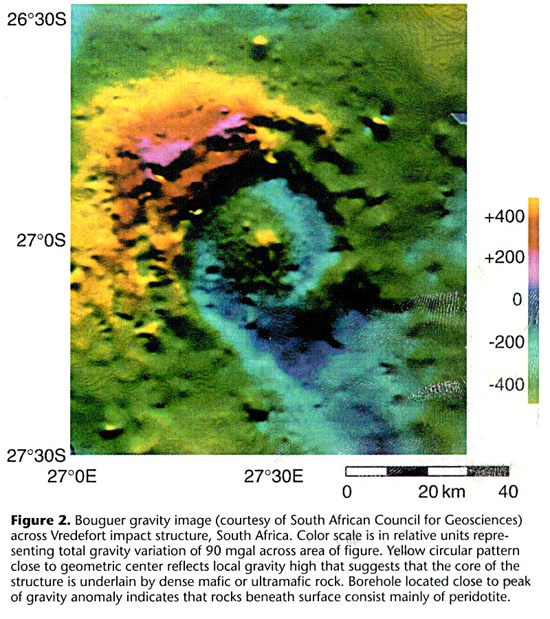
Bouger gravity image across the Vredefort impact
structure - seis1vred.jpg
Map of southern Africa showing Re-depletion model
ages measured for peridotite xenoliths from kimberlites - seis1sa1.jpg
The
Vredefort impact turned the Kaapvaal crust on its side such that the Archean
lower crust is exposed near the centre of the structure, which is also
the locus of a large positive gravity anomaly.
The anomaly has been drilled and found to be composed predominantly of
peridotite with Re-Os systematics (low Re/Os and 187Os/188Os values) and
Re-depletion model ages (3.3-3.5 Ga) similar to that of the Kaapvaal
lithosphere samples in kimberlites. The lithosphere is therefore
depleted, low density, buoyant, and 'stable', and the tectospheric root
should be characterised by higher seismic velocities.
Sapphirine granulite xenoliths derived from the lower crust by the Lace,
Voorspied, and Star kimberlites in the central part of the Kapvaal craton
between the Vredefort structure and the city of Bloemfontein indicate extreme
temperatures of >1100 degrees C, with zircon and monazite cooling
ages indicating metamorphism of of the lower crust at 2723 Ga.
This event was synchronous with the Venterdorp flood basalt event. However,
metamorphic zircons in granulites from kimberlites at the southern (northern
Lesotho) and southwestern margin of the Kaapvaal have ages of 1.050-1.000
Ga and 1.114-1.092 Ga, respectively, indicating that the lower crust of
the margins of the Kaapvaal were modified in the Mesoproterozoic much later
than the initial Archean cratonisation at 3.0 Ga.
Many Archean age eclogite xenoliths have oxygen isotopic
compositions commensurate with an origin as
subducted ocean floor basalt. The correlation of Re abundance with
oxygen isotopic composition also suggests that the Re-Os of the eclogite
protoliths were affected by oceanic hydrothermal alteration. [Note: all
diamond-bearing eclogites display oxygen isotopic
compositions comparable to mantle values and scatter
relatively little about a 3 Ga Re-Os reference isochron, whereas
diamond
free eclogites show considerablescatter
about the isochron. The latter variation may be attributed to processes
that involve mixing of different sources (metasomatism) or unmixing by
partial melting.] Some eclogite xenoliths have Proterozoic Sm-Nd
Cpx-Garnet ages, and sulfide grains in diamonds from Orapa kimberlite (Kaapvaal
craton) have both 3 Ga and 1 Ga Re-Os ages, with the 1 Ga age being similar
to that of silicate inclusions in the diamond. Other sulphide inclusions
have Mesozoic ages. Eclogitic diamond growth seems therefore to have taken
place during the cratonization and lithospheric keel-formation events,
during the accretion of the surrounding Namaqua-Natal orogenic belt, and
during Cretaceous magmatic underplating.
The crystallization products of melts derived from deep in the lithosphere
or beneath the lithosphere are believed to be represented by the Cr-poor
megacryst suite of minerals found in kimberlites. One group (group I kimberlites)
has a depleted source similar to HIMU (ocean island type), and a composition
reflecting the influence of a component exhibiting a long-term depletion
in Lu/Hf relative to Sm/Nd (i.e. light REE enriched), a
component possibly derived from the sub-lithospheric mantle.
GSA
Abst 2000
Session 74 Deep structure
of Archean Cratons, p. A-163
James, D. et al., Seismic studies of lithospheric structure beneath southern
Africa: implications for the formation and evolution of cratons, p. A-163.
High velocity tectospheric roots extend to
depths as great as 250 km and perhaps 300 km beneath the undisturbed Archean
Kaapvaal craton of South Africa. The crust beneath undisturbed Archean
craton is relatively thin (c. 35-40 km), is unlayered and has a relatively
sharp and simple MOHO bondary. Below the Archean Limpopo belt the mantle
is also "Archean cratonic" in character. There is a large
low velocity region in the deep mantle representing the upper reaches of
the African superswell.
However, over a wide swath beneath the 2.05 GA Bushveld intrusion,
mantle velocities are lower. Beneath
the Bushveld complex and the Proterozoic crust adjoining the Kaapvaal craton
the crust is 45-55 km thick and the MOHO signature is more complex. Crustal
separation in the Archean and was therefore efficient, and the crust -
mantle relationship has been stable since that time.
Silver, P.G. et al., Mantle deformation beneath southern
Africa, p. A-163
Seismic anisotropy studies indicate that Archean mantle deformation fabrics
are preserved in the Archean lithosphere. The seismic fabric (fast polarization
directions) follows the trend of the Great Dike and the Limpopo belt. Anisotropy
is however strongest under Late Archean terranes. Regions to the southwest
beyond the Kaapvaal craton are underlain by thin lithosphere and anisotropy
is considerably reduced. However, the minimal presence of anisotropy beneath
the older Kaapvaal craton to the southeast require an explanation perhaps
related to differences in continent forming processes during the early
and late Archean.
Carlson, R.W., et al. Chemical and age structure
of the southern African lithopsheric mantle: implications for continent
formation, p. A-163.
Lithospheric peridotites are typically highly depleted in compatible elements
(Ca, Al, Fe); depletion decreases slightly from the cratonic mantle (Fo=92.8)
to the surrounding Proterozoic mantle (Fo=91.9). Most peridoties show metasomatic
enrichment in incompatible elements. Re-Os-Al systematics show that the
metasomatic agent was either kimberlite or carbonatite. Peridotites from
on-craton localities have an Archean mean re-Os age of 2.9 Ga, slightly
younger than the overlying crust; all off-craton samples have Proterozoic
Re-depletion model ages (mean 1.6 Ga). There is no correlation between
age and depth of origin. Some eclogite xenoliths and eclogitic sulphide
inclusions in diamonds from on-craton kimberlites give late Archean Re-Os
ages suggesting that incorporation of mafic components
into into the lithospheric mantle accompanied craton formation in
the Archean. Stable isotopes indicate that some of
the eclogites were emplaced into the lithosphere by subduction.
Mantle xenoliths in the Premier kimberlites
, which erupted through the margins of the
Bushveld complex give Re-depletion model ages near 2.0 Ga, the approximate
age of the Bushveld.
Schmitz, M.D. et al., Constraints on the thermal
evolution of the deep crust of the Kaapvaal craton from U-Pb rutile thermochronometry
of Lower Crustal xenoliths, A-164.
Metamorphic zircon and monazite in Free State kimberlite sapphirine granulite
rocks have ages of 2.72 Ga, whereas rutile gives an age of 1.2 Ga
on an array trending to 2.4 Ga. Garnet granulite in Lesotho kimberlite
are 1.0-1.1 Ga but rutile is .6 Ga and .1 Ga. Smallest rutiles are concordant
at Cretaceous, as are rutiles from kimberlites at the southwestern margin
and from Botswana. Lower crust cooled through rutile closing temperature
at various times during the Proterozoic. reset thermal nergey related to
Namaquaq-Natal craton margin tectogenesis, or intra-cratonic mafic magmatism
related to the Karoo event and the breakup of Gondwana.
Flowers, R.M. et al. The Vredefort discontinuity
as a primary crustal boundary: implications for Kaapvaal lithospheric structure,
Vredefort impact structure, South Africa.
The apparent crustal cross-section preserves its primary intrusive relationships
: the amphibolite-granulite facies boundary is gradational over several
kilometers. Elongate quartz-syenite bodies subparallel the contactthe two
predominant fabrics that characterize the dicontinuity are Archean. . Although
there is not evidence for post-Archean meamorphism or deformation, Proterozoic
recrystallized monazite and Proterozic - Paleozoic authigenic zircons suggest
episodic hydrothermal events affected the Vredefort basement.
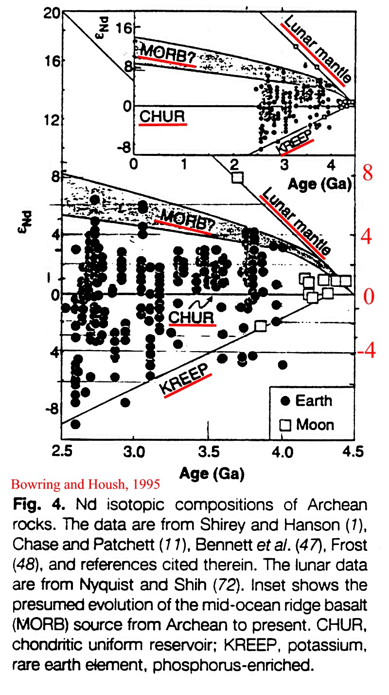
When
did continental crust form in the Archean?
Some komatiites
in older Archean belts have relatively high positive epsilon Nd values
indicating that they were derived from Sm relative to Nd enriched mantle
material, that is, from depleted mantle. These komatiites are also characterised
by low Al and Yb values, but high Ca values, and some rocks of this type
are also enriched in Fe and Ti. The low Al and Yb could be accounted for
by removal of garnet (HREE depletion) from the mantle source, but enigmatically
would not account for the high epsilon Nd values reflecting high Sm/Nd
(LREE depletion) of the mantle source. On the other hand Archean gneisses
exhibit epNd values ranging from juvenile values of +3.5 at 4 Ga and +7
at 2.7 Ga to crustal values of -9 at 2.7 Ga. Whereas the negative epNd
values likely reflect crustal recycling and/or crustal contamination, the
variation in positive values of komatiitic rocks may represent primary
variations in mantle chemistry or crustal recycling. The existence of values
as high as +3.5 in the 4 Ga-old Acasta gneisses indicates that a depleted
mantle reservoir existed by this time, whereas the negative values exhibited
by some 3.6 Ga gneisses implies the existence of continental crust even
at this early stage of the Earth's evolution.
Variation
in Epsilon Nd values for Archean rocks with ages between 4.0 and 2.5 Ga
(see Bowring and Housh, 1995)
The total area of crust older than 3.8 Ga is small, but nevertheless present in North America, West Greenland, China, Antarctica, and Western Australia. The limited amount of old crust is thought to relect the efficiency of recycling mechanisms during the Archean. However, as indicated in the report below it would seem unlikely that crust older than 3.9 Ga would be preserved in the present Archean inventory.
Lunar
meteorite ages present new, strong evidence for the bombardment of the
moon just as life was beginning on Earth.
This event would have occurred when the first evidence of life appeared
on Earth, according to scientists writing in the US journal Science last
week (December 1 2000).
Whether or not there was life on Earth at the beginning of the bombardment,
such cataclysmic pounding would have enormous consequences for life on
this planet, whether by destroying existing life or organic fragments or
by delivering molecules and creating conditions suitable for life,
the researchers add.
Barbara Cohen of the University of Tennessee -- Knoxville analysed the
lunar meteoriteages for her dissertation research at the University of
Arizona in Tucson. Timothy D. Swindle and David A. Kring of the UA collaborated
on the study and are co-authors on the Science article. Swindle supervised
Cohen's research. Kring is an expert in impact cratering and one of the
discoverers of the K/T boundary Chicxulub impact site. Moon rocks
returned by the Apollo and Luna missions in the 1970s suggested that Earth's
moon was blasted in a maelstrom of solar system debris at 3.9 billion years
ago. A great swarm of asteroids or comets pounded the lunar surface during
a brief pulse in geologic time, melting rocks, excavating vast craters
and resurfacing Earth's natural satellite.
But for safety and communications reasons, both manned and robotic spacecraft
were landed near the moon's equator, on the side facing Earth. No one could
say if just this part of the moon or the entire moon had suffered.
Cohen, Swindle and Kring bring the most significant data in nearly 30 years
to bear on this question. They used an argon-argon dating technique in
analysing impact melt ages of four lunar meteorites -- rocks ejected at
random from the moon's surface and that landed on Earth after a million
or so years in space. They find from the ages of the clasts (melted rock
fragments) in the breccia meteorites that the
entire moon was bombarded 3.9 billion years ago, a true global lunar cataclysm.
Further, although the moon may have been bombarded
before 3.9 billion years ago, the scientists find no evidence for it.
If there were no earlier bombardment, scientists must jettison theoretical
models that assume a steady falloff in the lunar and inner solar system
cratering rate through time.
"Given the model of what was going on in the solar system, there is no
obvious reason why you should suddenly have a bunch of things banging on
the moon 4 billion years ago and not 4.2 billion years ago," Swindle said.
But the most dramatic implication is what happened during this event on
Earth. "The Earth is a much bigger target than the moon, " said Kring,
associate professor at the UA Lunar
and Planetary Lab. "Earth would have been bombarded
by at least 10 times as many impact events as the moon, and these
impact cratering processes are immense."
The Chixculub crater that we identified, which is related to the mass extinction
of dinosaurs and other life 65 Ma ago, is puny by comparison to the scheme
we are talking about. Here we are talking about impacts that are 10 times
larger, impacts that blasted craters rim-to-rim the size of continents
on Earth today." "The bombardment would have charged
the atmosphere with silicate vapour and vaporised the oceans, so if there
was life on Earth before the bombardment, the question is what, if
anything, survived," Swindle said. Perhaps some genetically primitive
"extremeophiles" survived, he added. This kind of life is found on Earth
today deep in rocks or living at the ocean vents. What did the bombarding?
More
likely asteroids than comets, based on some evidence from meteoritic
trace constituents involved in the impacts and on other studies on what
was happening at the time in the asteroid belt, Kring suggests.
"When we first
started this research, the goal was to find something older than 3.9 billion
years," Cohen said. "We were very surprised at the evidence presented by
seven different impacts, which pointed to 3.9 billion years." Swindle
said, "Going into this study, I would have bet that we wouldn't have found
these results. I would have bet that we would have seen impacts earlier
than 3.9 billion years ago."
Late
Heavy Bombardment was asteroidal, not cometary, Geological Society website,
March 4, 2002
The bombardment that resurfaced the Earth 3.9 billion years ago was produced
by asteroids, not comets, according to David Kring (University of
Arizona Lunar & Planetary Laboratory) and Barbara Cohen (University
of Hawaii). Their findings appear in the February 28 edition of the Journal
of Geophysical Research published by the American Geophysical Union.
The significance of this conclusion is that the bombardment was so severe
that it destroyed older rocks on Earth. Which, Kring says, is the reason
why the oldest rocks found are less than 3.9 billion years (Ga) old.
Additionally, they argue, impact-generated hydrothermal systems would have
been excellent incubators for pre-biotic chemistry and the early evolution
of life, consistent withprevious work that shows life originated in hot
water systems around or slightly before 3.85 Ga ago.
This same bombardment affected the entire inner solar system, producing
thousands of impact craters on Mercury, Venus, the Moon and Mars.
Most of the craters in the southern hemisphere of Mars were produced during
this event.
On Earth, at least 22,000 impact craters with diameters greater than 20
kilometres were produced, including about 40 impact basins with diameters
of about 1000 kilometres in diameter. Several impact craters of about 5,000
kilometres were created as well - each one exceeding the dimensions of
Australia, Europe, Antarctica or South America. The thousands of
impacts occurred in a very short period of time, potentially producing
a globally-significant environmental change at an average rate of once
per 100 years.
Also, the event is recorded in the asteroid belt, as witnessed by the meteoritic
fragments that have survived to fall to Earth today.
Oceanic crust formed at oceanic ridges is positively buoyant. As it moved laterally away from the ridge, the underlying lithospheric part of the plate progressively cools and thickens - the thickness of the plate is proportional to the square root of its age. If the crust and lithosphere is composed of basaltic crust (top layer), depleted lithospheric mantle (middle layer), and lithospheric mantle (bottom layer) overlying asthenospheric mantle, then:
D-asthenospheric-mantle = [D-basaltic-crust x h-basaltic-crust + D-depleted-lithosphere x h-depleted-lithosphere + D-lithosphere x (h-plate - h-basaltic-crust - h-depleted-lithosphere)] / h-plate, where D refers to density and h to thickness of the relevant layers (D-basaltic-crust < D-depleted-lithosphere < normal-lithosphere).
Neutral buoyancy is achieved when the mean density of the plate is equal to the density of the underlying mantle. At the present time, oceanic plates achieve neutral buoyancy after about 20 Ma, or at a spreading rate of 3-5 cm / year, within a distance of 600-1000 km of the ridge, and the mean age of present-day plates when they reach the subduction zone is 100 Ma (5000 km at 5cm /year).
If, during the
Archean, the mantle was hotter by 60 degrees, the age of neutral buoyancy
would have been greater. A hotter mantle would also have had a lower viscosity
and would have convected faster. Consequently, the age of the crust at
the subduction zone may have been less than the present average age of
100 Ma, and the crust may have therefore still been positively buoyant
during attempted subduction. The tectonics of subduction may not have been
as they are at the present time, and Archean crust may have amalgamated
as hydrated thrust piles which were eventually subject to partial melting
as they 'dripped' into the mantle, thus giving rise to the Archean tonalite
terranes.
Illustration
of the buoyancy problem - arch2supbuoy.jpg
It is noticeable
that Archean sediments invariably do
not show marked positive Eu anomalies and
are therefore unlikely to have been derived from a crust enriched in K-granites.
Such crust appears only at the end of Archean crustal differentiation cycles,
for example at 2.7 Ga in the case of the Canadian Shield. The K-rich granites
represent small partial melts of the older tonalitic component of the Archean
crust, and were perhaps formed following the achievement of some critical
mass and subsequent thickening and underplating to provide heat for the
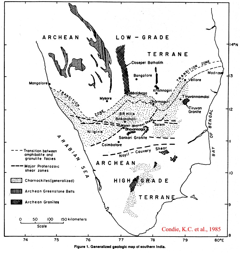
partial melting. The principles involved in the generation of Eu-depleted
granitoids by the partial melting of Archean tonalite are illustrated in
the following data diagrams (Condie et al, 1985):
Generalized
geologic map of southern India - lprotmysore.jpg
Chondrite-normalized
REE patterns for Archean tonalites and granites - lprotmysoreree.jpg
Peck,
William H; King, Elizabeth M., Valley, John W. 2000. Oxygen isotope perspective
on Precambrian crustal growth and maturation. Bull. Geological Society
of America. 28, 4, Pages 363-366.
AB: In this
study we contrast insights on Precambrian crustal growth and maturation
from radiogenic and oxygen isotope systematics in the Superior (3.0-2.7
Ga) and Grenville (1.3-1.0 Ga) provinces of the Canadian Shield. Oxygen
isotope ratios in zircon provide the best evidence of supracrustal input
into ancient orogens. Archean Superior Province zircons
have relatively low delta 18O values and a limited range (5.7% +/- 0.6%),
while Proterozoic Grenville Province zircons have elevated delta 18O values
and a wider range (8.2% +/- 1.7%). These data reflect fundamental
differences in crustal evolution and maturation between the Superior and
the Grenville provinces. In the Grenville Province,
radiogenically juvenile supracrustal material with high delta 18O values
was buried (or subducted) to the base of the crust within 150 m.y. of initial
crust production, causing high magmatic delta 18O values (delta 18O [zircon]
> or = 8%) in anorthosite suite and subsequent plutons. Information
about large volumes and rapid recycling of Grenville crust is not accessible
from radiogenic isotope data alone. The Grenville data contrast with the
restricted delta 18O values of Superior Province magmatism, where subtle
( approximately 1%) elevation in delta 18O occurs only in volumetrically
minor, late to postorogenic (sanukitoid) plutons. Differences
in sediment delta 18O values between the Superior and Grenville provinces
are predominantly a function of the delta 18O of source materials, rather
than differences in chemical maturity or erosion styles. This study
shows that zircon is a robust reference mineral to compare igneous processes
in rocks that have undergone radically different histories.
Primodial
air may have been 'breathable' - Journal of the geological Society Web
site, January 10, 2002
The Earth may have had an oxygen-rich atmosphere as long ago as three
billion years and possibly even earlier, three leading geologists
have claimed.
Their theory challenges long-held ideas about when the Earth's atmosphere
became enriched with oxygen, and pushes the likely date for formation of
an atmosphere resembling today's far back into the early history of the
planet.
It may also revolutionise the worldwide search for gold and other minerals,
and raises new questions about when and how life could have arisen.
Evidence for the presence of oxygen in the primitive atmosphere was put
forward
by the Chief of CSIRO
Exploration and Mining Professor Neil Phillips, Australian-based South
African geologist (picture) Mr Jonathan Law and US gold mining consultant
Dr Russell Myers in a publication by the Society for Economic
Geology.
"These findings may have enormous economic implications in that we may
simply have been looking in the wrong places for massive gold deposits
like South Africa's Witwatersrand," says Professor Phillips. "Or we may
actually have found them - and not recognised them for what they are, because
we did not understand the processes involved in their formation."
The scientists base their case on the presence of iron-rich nodules in
the deep strata of the Witwatersrand -
nodules they believe
are pisoliths, small balls containing ferric iron produced by exposure
to an oxygen-rich air. Pisoliths still form nowadays and provide important
clues in the search for minerals, including gold. Those found in
the Rand come from levels 3-4 kilometres down, which are securely dated
at 2.7 to 2.8 billion years old. The researchers' theory has been lent
additional weight by evidence from the Western Australian Pilbara region
for the presence of sulphates in rocks up to 3.5 billion years old. These,
too, could not have formed without an oxygen-rich atmosphere.
Pisoliths have been a vital tool in the discovery of A$5 billion worth
of new gold deposits in WA in recent years, using techniques developed
by CSIRO's Dr Ray Smith, Dr Charles Butt and Dr Ravi Anand. The small iron-rich
balls form from iron in groundwater and 'scavenge' traces of other minerals
in the local environment. They provide clues, like fingerprints, which
point to deposits lying hidden beneath metres of inscrutable surface rubble.
By analysing pisoliths over a wide area for gold content, geologists can
construct a pattern of steadily enriching traces, with the hidden deposit
lying like a bullseye at the heart of it, usually a bit uphill. Some geologists
believe living organisms may play a part in the formation of pisoliths,
raising tantalising questions about the nature and role of life in
shaping the Earth's early surface and mineralisation.
The presence of pisoliths in the deep strata of the Rand suggests that
the conditions for mineral formation 3
billion years or
so ago were different to what many geologists have believed for the past
half-century, the team say. These ideas have already been integrated into
a new exploration model for the formation of the Rand deposits by the same
researchers.
The Rand is unique on Earth - a vast body of rock very rich in gold. The
mightiest gold deposit ever found. Nothing like it has been discovered
elsewhere. Professor Phillips says that this may be because we didn't
know what to look for, because we made wrong assumptions about the conditions
in which it formed. In other words, fresh Rands may still await discovery.
Some geologists speculate one of them, at least, lies in central Western
Australia .
Huston-David-L; Taylor-Bruce-E; Bleeker-Wouter;
Watanabe-Donald-H, 1996. Productivity of volcanic-hosted massive sulfide
districts; new constraints from the delta 18O of quartz phenocrysts in
cogenetic felsic rocks. Bull. Geological Society of America, 24,
5, p. 459-462.
AB: A correlation has been established between Zn productivity of volcanic-hosted
massive sulfide districts and delta 18O of quartz phenocrysts from cogenetic
rhyolitic rocks. In highly productive districts, ores are associated
with rhyolitic rocks, of possible S-type affinity, containing high delta
18O quartz phenocrysts. In less-productive districts, ores are associated
with I-type rhyolitic rocks with low delta 18O phenocrysts. This correlation
may be caused by (1) low-temperature isotopic alteration that produced
18O-rich overgrowths on phenocrysts, and (2) emplacement of transitional
S-type intrusions at greater depths than I-type intrusions, resulting in
larger hydrothermal cells and allowing leaching of more Zn. The latter
hypothesis is favored.
Theres bugs in them thar rocks - from Geological Society Web site, March 22, 2002, US scientists confirm biological origin of earliest fossils
UCLA paleobiologist J. William Schopf and colleagues have substantiated
the biological origin of the earliest
known cellular
fossils, which are 3.5 billion years old. The research was published in
the March 7 issue of the
journal Nature.
Schopf and a team of scientists at the University of Alabama, Birmingham
have devised a new technique using an unique laser-Raman imaging system
that enables them to look inside of rocks and determine what they are made
of, providing a molecular map.
"This new technique is a tremendous breakthrough, and is something we have
sought for 25 years" Schopf said.
"Because Raman
spectroscopy is non-intrusive, non-destructive and particularly sensitive
to the distinctive
carbon signal of
organic matter of living systems, it is an ideal technique for studies
of ancient microscopic
fossils. Raman
imagery can show a one-to-one correlation between cell shape and chemistry,
and prove whether
fossils are biological."
Schopf and his colleagues applied the new technique to ancient fossil microbe-like
objects, including the oldest specimens reported from the geological record.
"There is no question at all that we have substantiated the biological
origin of the oldest fossils now known" Schopf said. "We have established
that the ancient specimens are made of organic matter just like living
microbes, and no non-biological organic matter is known from the geological
record. In science, facts always
prevail, and the
facts here are quite clear."
Erosion's a gas - Geological Society web site, March 21, 2002, Martian surface features were eroded by liquid carbon dioxide, not running water, researchers say
Scientists have provided new evidence that liquid carbon dioxide, not
running water, may have beeen the primary cause of erosional features such
as gullies, valley networks, and channels that cover the surface of
Mars. Research suggesting
that condensed carbon dioxide found in Martian crust carved these features
is reported by Kenneth L. Tanaka and colleagues at the US Geological Survey
in Flagstaff, Arizona, and the University of Melbourne, Australia, appeared
this month in Geophysical Research Letters, published by the American Geophysical
Union.
Using Mars Orbiter Laser Altimeter (MOLA) data, Tanaka and his
colleagues constructed
elevation profiles of the Hellas basin, which, at 2000 kilometres wide
and nine kilometres deep, is the largest well-preserved impact basin on
Mars. By examination of digitally created elevation profiles with 500-metre
resolution, they found that the volcanic regions of Malea and Hesperia
Plana, along the rim of the Hellas basin, are several hundred meters [yards]
lower than adjacent rim sectors. Additionally, these areas lack the prominent
triangular peaks, called massifs, that are common in nearby areas.
Along the inner slopes of these regions, the researchers found, however,
evidence of old massifs covered by
volcanic rocks.
They are too low to be covered, if there were volcanic activity today.
The researchers suggest as an explanation that prior to volcanic activity,
these regions along the rim of the basin resembled nearby areas, but
were eroded to their present-day elevations following the emplacement of
the volcanic rocks.
Tanaka and his colleagues propose a "magmatic erosion model" to explain
the features of the volcanic areas of
Malea and Hesperia Plana,
suggesting that they underwent catastrophic erosion associated with explosive
eruptions of molten rock.
They suggest that liquid in the Martian crust was heated when molten rock,
or magma,
rose to the surface.
As the liquid was heated, it expanded, until the pressure of overlying
material was too great,
and an explosive
eruption occurred, shattering overlying rock, and causing it to move with
the magma in an
erosive debris
flow.
The authors believe that the fluid in the crust along this area of the
rim of the Hellas basin was mainly liquid carbon dioxide. A debris flow
dominated by carbon dioxide would flow faster and farther than a water-based
flow, they
say. Also, carbon
dioxide is more volatile than water at lower temperatures, and the cold
temperatures found on
Mars would mean that
less carbon dioxide-based magma would be required to produce the observed
erosion
than magma containing
mainly water.
The researchers suggest that this mechanism of erosion can also explain
collapse features and channels
elsewhere on Mars.
They also note, however, that their model is based on a variety of assumptions
that must be
further tested.
Continental Growth through time (15cntgrw.gif)
Structural Provinces of the Canadian Shield (14strprv.gif)
Subprovinces of the Superior Province
Timmins Kirkland Lake Noranda area
The Kirkland Lake area
The Slave Province
Major dike swarms of the southern Superior Province
Isotopic ages - Abitibi belt
2980 single grain in Timiskaming, Davis 1991
2900 oldest Michipicoten volcanics, Corfu and Sage 1992
2840 - 2760 20% of detrital zircons from Abitibi belt sediments, Davis 1991
2750 - 2720 xenocrystic zircons in porphyry and lamprophyre of Larder Lake
2747 Pacaud tuffs, Mortensen 1993
2736 Older Temagami volcanics, Bowins and Heaman 1992
2730-2725 Normetal - Hunter Mine, Lac Abitibi region = Deloro, Timmins area
2727 Upper Deloro, Corfu et al. 1989
2725 Majority of detrital zircons in Abitibi belt sediments
2724 Mattagami volcanics, Ep = 2.5, Vervoort et al 1991
2717 Kidd Creek, Barrie et al. 1988 (quoted by Davis et al 1991); Schandle et al. 1990
2714-2713 Hunter Mine volcanics, Corfu et al 1989
2710-2700 Youngest Michipicoten volcanics, Corfu and Sage 1992
2705 Larder Lake; Corfu et al. 1989; Blake River volcanics, Machado et al. 1991
= Columbiere rhyolite of Val d'Or, Mortensen 1993
2703 Upper Tisdale Corfu et al. 1989
2701 Blake River Gp., Skead Gp., Corfu et al 1989
2698 Upper Tisdale Krist Pyroclastic = Clericy rhyolite of the Blake River, Mortensen 1993
trondjemite bounder in Dore conglomerate of Michipicoten, Corfu and Sage 1992
2696-2670 Sanukitoids, Ep 1.8-3.7
2695-2688 thrusting of 2700 volcanics over 2750-2720 volcanics in the Larder Lake region
2693 (2703-2683) hydrothermal zircons, quartz-tourmaline-gold veins (Kerrich & Kyser, 1994)
2687 lamprophyre, Barrie & Tucker 1990 (Au is younger); youngest zircons in the Kewagama;
Younger Temagami volcanics, Bowins and Heaman, 1992
2686 Baie de Lys gneiss, Lac Simard Nord monzonite Machado et al. 1991;
to 2680 detrital zircons in the Timiskaming, Corfu et al. 1991
2685+3 Bidgood qtz porphyry, Corfu et al. 1991
2683 minimum age of Kewagama
2682 Clericy syenite (cuts Kewegama), Mortensen 1993
2681 Younger detrital zircons in Central and Northern Michipicoten; seds cut by 2671 granodiorite Corfu and Sage 1992
2680 Otto stock ?; 2679 maximum age of Timiskaming
2678 Lac Maple granodiorite (has inherited zircons of 2692), Machado et al 1991
2677 +3 porphyry dike cutting Timiskaming of Larder Lake region
= volcanic agglom. of the Bear Lake Fm north of Larder Lake
=minimum age of Timiskaming
2673 titanite in lamprophyre, Wyman and Kerrich 1987
2671+8 Otto stock, ion probe age, Ben Othman 1990 Ep volcanics = 2.5+1.5
Michipicoten granodiorite, Corfu and Sage 1992
2669 Belleterre monzodiorite Machado et al. 1991
2660 concordant titanite in Opatica gneiss = metamorphic episode, Machado et al. 1992
2645 Most S-granites in the Pontiac, range 2663-2611, Feng and Kerrich 1991
2637 concordant titanite in Baie de Lys gneiss = metamorphic episode, Machado et al. 1992
2632 Halle intrusive (inherited zircons of 2702) = ae of Au mineralization, Machado et al. 1992
2624+6 Hydrothermal rutile, Kidd volcanic centre, Schandle et al. 1990
2630-2579 U-Pb ages on gold vein rutile and titanite (Kerrich and Kyser, 1994)
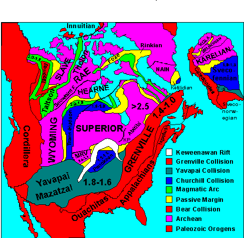
Structural Provinces of North America.
RETURN TO:
Click here to return to beginning.