Click
here to return to course outline.
The Canadian Cordillera
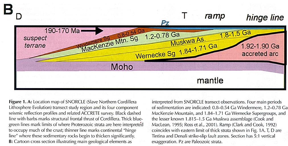
Click here to see cross section
In its simplest form the Canadian Cordillera has been represented as a bisymmetrical unit composed of three tectonic zones:
Western Cordilleran Fold Belt | Intermontane zone | Eastern Cordilleran Fold Belt
Subdivided further into:
Insular Zone Eastern Marginal Zone
The Core zone, commonly also known as the Omineca Geanticline, merges at its northern end with the Yukon-Tanana Platform, a structural unit which to the west of the Intermontane zone can be traced southwards into the Coast Crystalline complex.
The relative plate tectonic evolution of these three tectonic elements remains one of the major 'unknowns' of Cordilleran and Canadian geology.
In terms of the concept of 'suspect terranes', the Cordillera is now recognized as an accretionary complex composed, from east to west, of the following native and accreted terranes:
Native
1) The North American
craton and its cover of deformed Phanerozoic sediments (oil bearing).
2) North American craton
rocks forming uplifted core complexes within the Omineca
- the Monashee
3) Displaced continental
margin rocks
- the Cassiar (north) and Cariboo (south)
4) Pericratonic terranes
- Kootenay: Barkerville
(south), Nisutlin, Yukon-Tanana (north), and Nisling? (west)
Accreted
terranes
5) Intermontane Superterrane
Slide
Mountain Ocean (East), Quesnellia arc, Cache Creek ocean, Stikinia arc
(West)
6) Coast Belt
a) Southern Cordillera - Methow (East);Bridge River/Hozameen
(= Cache Creek?), Cadwallader,
Shuksan (West)
b) Northern West Coast - Taku
c) Gravina
7) Insular Superterrane
a) Inner - Alexander (East) Wrangellia (West)
b) Outer - Chugach (East), Yakutat (West)
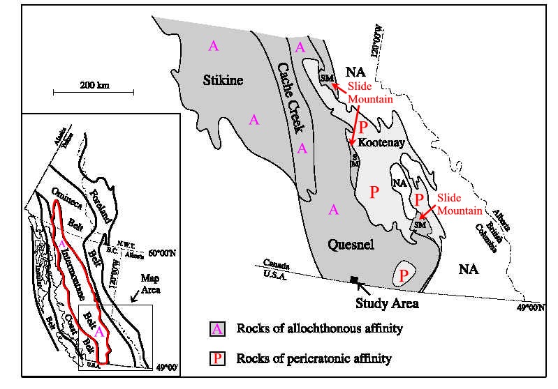
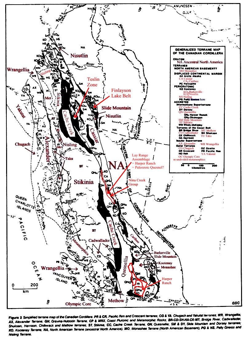
Terrane Map of the Canadian Cordillera - cord2terr1.jpg
Simplified terrane map of the Cordillera
A detailed but incomprehensible grey scale map of the Canadian Cordillera - cord2mapcan.jpgThe Pericratonic terranes contain volcanic and continental derived sedimentary rocks laid down during early Phanerzoic rifting of the western margin of North America They have a late Proterozoic to Paleozoic history of deformation and plutonism.
Geological Time Chart, Phanerozoic, GSC-1999
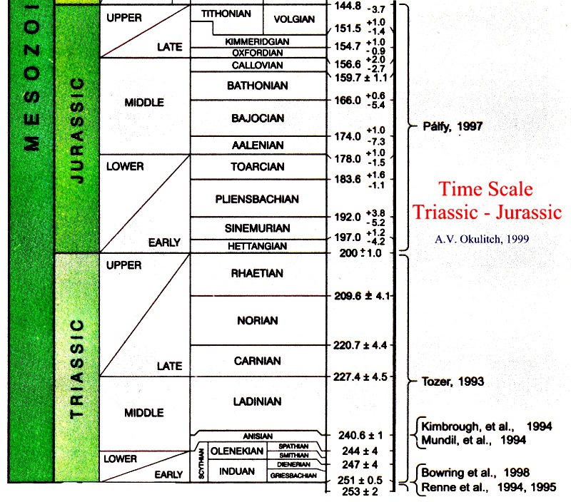
Geological Time Chart: Triassic-Jurassic, GSC-1999
Middle Jurrassic to Paleogene tectonic events in the Canadian Cordillera - cord2terr2.jpgCLICK HERE TO GO TO THE TAYLOR LIBRARY
The continental margin miogeoclinal rocks (Ketchika basin) of the Cordilleran SystemFerri, Filippo, Rees, Chris, Nelson, JoAnne, Legun, Andrew, Orchard, M-J, Norford, B-S, Fritz, W-H, Mortensen, J.K, Gabites, J-E, 1999. Geology and mineral deposits of the northern Kechika Trough between Gataga River and the 60th parallel. Bulletin - British Columbia Ministry of Energy and Mines, Energy and Minerals Division, Geological Survey Branch. 107, 122 p., 2 sheets.
Smith, M. Gehrels, G., 1994, Detrital
zircon geochronology and the provenance of the Harmony and Valmy formations,
Robert Mountains allochthon, Nevada: BGSA, 106, 7, 968-979.
Abstract- Valmy zircons - 2 of
1050, 4 of 1830-1845, 5 of 1910-1960, 2 of 2270-2340, 8 of 2650-2750, 1
of 2900 and discordant ages 1 of 2070 1 of 3240; derivation from the North,
Slave Craton and Medicine Hat province and central/northern Alberta; Valmy
is Ordovician volcanic bearing equivalent of the Eurekea Quartzite of the
shelf miogeocline; Harmony Fm is Upper Cambrian and immature, zircons -
9 of 695-710, 12 of 1015-1225, 2 of 1330, 1 of 1745, 1 of 1915, 1 of 2570;
the c 700 and c 1100 have no western North American basement source; five
foliated intrusive bodies spatially associated primarily with the Windermere
Supergroup and Yukon-Tanana terrane , as well as one extrusive unit Mount
Harper rhyolite in the Ogilvie Mountains 751+26-18, yield ages in the 670-750
range. Two 680 orthgneiss bodies occur in the Seward Peninsula;evidence
for Grenville age basement includes clasts and xenoliths entrained in two
diatremes and a monazite age from a breccia pipe; Pahrump sills of Death
Valley are 1069 1087 and sills in the Apache quartzite of Arizona are 1150
Ma.
What is the Monashee?James L. Crowley, 2001. U-Pb geochronologic constraints on Paleoproterozoic tectonism in the Monashee complex, Canadian Cordillera: Elucidating an overprinted geologic history Canada.Geological Society of America Bulletin: Vol. 111, No. 4, pp. 560577.
What is the age, source, and nature of Slide Mountain rocks?Nelson, J.L., 1993. The Sylvester Allochthon: Upper Paleozoic marginal-basin and island arc terranes in northern British Columbia. CJES, 30, 631-643.
Roback, R.C., Sevigny, J.H., and Walker, N.W., 1994.
Tectonic setting of the Slide Mountain terrane, southern British Columbia.
Tectonics, 13, 5, 1242-1258.
Abstract - SMT consists of fine
grained quartzose clastic rocks, limestone and lesser amounts of conglomerate
and volcanic rocks of the Carboniferous McHardy assemblage conformably
overlain by the Permian Kaslo Group ultramafic, volcanic and sedimentary
rocks. Kalso volcanics are MORB. McHardy conglomerates
contain clasts of Silurian granitoid rocks,
and detrital zircons in the McHardy are 1.7 to 3.1 Ga, similar to ages
of zircons in the Kootenay and miogeoclinal sediments. The SMT is unconformably
overlain by Late Triassic fined grained sedimentary rocks of the Slocan
Group of the Quesnellia terrane (Monger and Berg, 1987). The Slide
Mountain may therefore be in part a 'native' foreland basin assemblage,
rather than an exotic section of oceanic crust.
Henderson-Charles-M,
1998. Tectonic control and biotic change at the Permian-Triassic (P-T)
and Dienerian-Smithian (D-S) sequence boundaries, Western Canada.
Abstracts with Programs - Geological Society of America. 30, 7, p.
152.
Abstract - Permian and Lower Triassic
strata in western Canada are difficult to correlate because of major thickness
and lithofacies variations and the scarcity of index fossils. However,
sequence biostratigraphic analysis using conodonts, has resulted
in the development of a complex tectono-stratigraphic history for
the cratonic margin of northwestern Pangea. At least five third-order sequences
are recognized for the Permian and Lower Triassic of western Canada. A
thin Upper Asselian/Lower Sakmarian sequence, is sporadically distributed
as a result of sub-Permian tectonic uplift and buckling on the craton margin.
The remaining two Permian sequences (Artinskian-Lower Kungurian and Roadian-Wordian)
are more widespread and are characterized by condensed sedimentation and
decreasing biotic diversity that point to a protracted extinction interval.
A low diversity Upper Permian fauna is dominated by siliceous sponges and
associated with dropstones, suggesting that climatic cooling as well as
the subsequent regression were important contributing factors to the P-T
extinction locally. Truncation of various Upper Paleozoic units and localized
distribution of latest Permian and earliest Triassic strata indicates another
major
tectonic uplift and buckling event that correlates with the Sonoman Orogeny,
immediately before the Permian-Triassic biostratigraphic boundary.
A relatively thick latest Changhsingian to Dienerian sequence includes
a very low diversity fauna and few ichnotaxa. The D-S sequence boundary
has a comparable tectonic signature that isolated overlying biotic accumulations,
forming important reservoir units in the region. Evidence supports
emplacement of allochthonous terranes (Slide Mt.)
onto pericratonic terranes (Kootenay) and
imbrication
of Upper Permian rocks beginning in pre-Late Triassic time. Therefore,
it is probable that tectonic stress buildup and release events associated
with major plate reorganizations or interaction between the craton margin
and pericratonic and allochthonous terranes controlled these northwestern
Pangea sequence boundaries and influenced biotic extinction and migration
patterns.
Struik,
L.C. and Orchard, M.J., 1985. Late Paleozoic conodonts from ribbon chert
delineate imbricate thrusts within
the Antler Formation of the Slide Mountain terrane,
central British Columbia. Geology, v. 13, no. 11, pp. 794-798.
Structural relationship of the Slide Mountain, Cariboo and Quenelle terranes - cord2struik.jpg
Is Quesnellia 'exotic' or 'native'?Armstrong, R.L. and Ghosh, D.K. 1990. Westward movement of the 87Sr/86Sr=0.704 line in southern B.C. from Triassic to Eocene time: monitoring the tectonic overlap of accreted terranes on North America. GAC Abst. w. Prog., Vancouver, pA4.
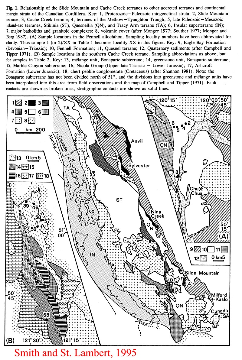
Smith, A.D. and Lambert, R.S., 1995.
Nd, Sr, Pb isotopic evidence for contrasting origins of late Paleozoic
volcanic rocks from the Slide Mountain and Cache Creek terranes, south-central
British Columbia. CJES, 32, 447-459.
Map
of sample areas in the Fennel allochton (Slide Mountain) and southern Cache
Creek terranes - cord2smith1.jpg
Comment - Slide Mountain Fennell
Fm Late Pennsylvanian basalts resemble MORB but have kaersutite or augite
dominated mineralogies; EpND300 = +7.7 to +10.2. Pb isotope values
favour a marginal basin rathern than a back arc. Cache Creek of the Bonaparte
subterrane (middle Mississippian?) are within-plate. EpNd340 = +4.2-+5.6,
and lead shows a transition towards DUPAL signatures. Baslatic andesite
and andesitic tuffs, also found in the Bonaparte subterrane, are tentatively
correlated with Late Triassic to Early Jurassic low-K tholeiite of the
Nicola Group of Quesnellia.
Smith, A.D., Brandon, A.D., and
Lambert, StJ., 1995. Nd-Sr isotope systematics of Nicola Group volcanic
rocks, Quesnel terrane. CJES, 32, 4, 437-446.
Comment - EpsilonNd3\222 = +5.1
- +7.8 = early Mesozoic island arcs; +5 - +7.9 for picrite -shoshonite
samples.
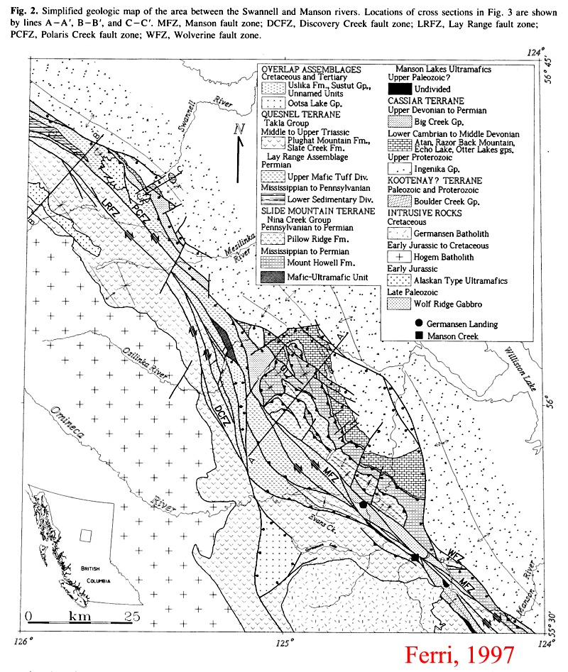
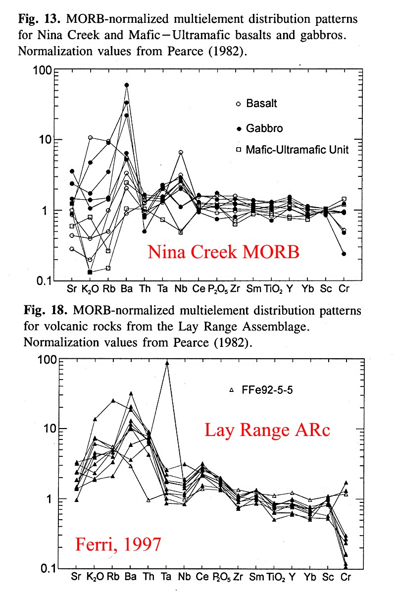
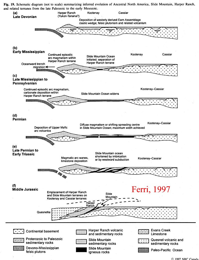
Ferri, F., 1997. Nina Creek Group
and Lay Range assemblage, north-central British Columbia: remnants of late
Paleozoic oceanic and arc terranes. CJES, 34, 853-874.
comment: volcanic rocks are MORB
with no interbedded arc rock types.
Distribution
of Slide Mountain and Harper Ranch terranes along the length of the Cordillera
- cord2ferri1.jpg
Map
of the Nina Creek area - cord2ferri2.jpg
Stratigraphy
of the Nina Creek Group and Lay Range assemblage - cord2ferri3.jpg
Spidergrams
for the Nina Creek Group and Lay Range assemblage - cord2ferri4.jpg
Plate
tectonic model with Slide Mountain as a back arc basin - cord2ferri5.jpg
Erdmer, P. Thompson, R. I., and
Daughtry, K. L., 1999. Pericratonic Paleozoic succession in Vernon and
Ashcroft map areas, British Columbia. In: Cordillera and Pacific margin/
Interior Plains and Arctic Canada. Current Research - Geological Survey
of Canada. 205-213.
Comment:
Ductilely deformed and metamorphosed pericratonic rocks of inferred Early
Paleozoic age overlie the
Neoproterozoic-Eocambrian Silver
Creek schist in the Vernon map area along an apparent stratigraphic contact.
Permian
(Harper Ranch Group) and Triassic (Nicola Group and Slocan Formation) strata
overlie the pericratonic succession along an unconformable depositional
contact. The pericratonic succession, long recognized to include
amphibolitic schist, marble, and quartzite, includes in addition
to these a distinctive metaconglomerate, and forms a robust regional
marker. The tripartite regional stratigraphy and its inferred Proterozoic
or older depositional basement cross the Okanagan Valley without apparent
offset, and persist for at least 100 km westward, as far as the Nicola
horst. The pericratonic succession underlies rocks presently assigned
to the Quesnellia terrane at this latitude.
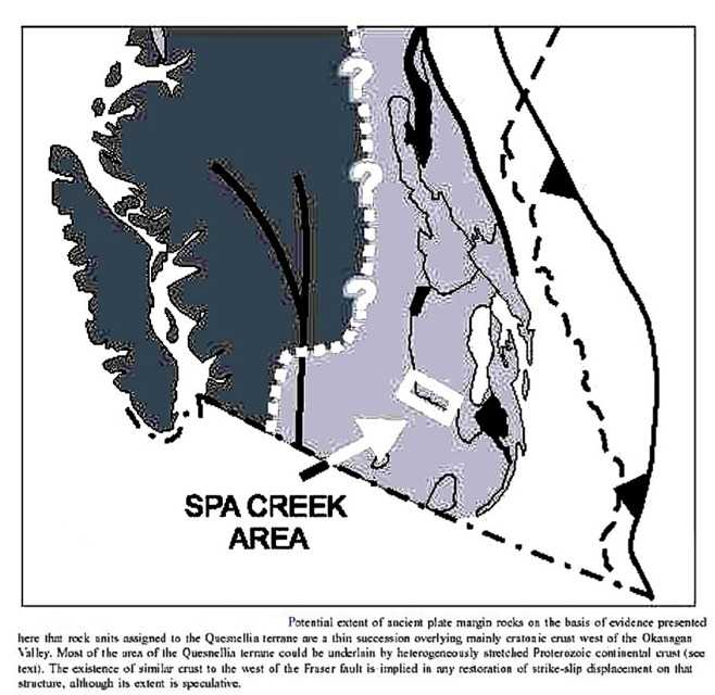
Eocambrian granite clasts in southern British Columbia
shed light on Cordilleran hinterland crust Philippe Erdmer, Larry
Heaman, Robert A. Creaser, Robert I. Thompson, and Ken L. Daughtry
Can. J. Earth Sci./Rev. Can. Sci. Terre 38(7): 1007-1016
The Spa Creek assemblage is a distinctive thin pericratonic succession
that crosses the Okanagan Valley in the hinterland of the southern Cordilleran
Orogen in Canada. The succession was ductilely deformed and metamorphosed
before deposition of overlying Triassic dark metaclastic strata. A metaconglomerate
within the succession, locally composed of more than 90% biotite
granite clasts, yielded five fractions of euhedral zircon that define a
precise UPb upper intercept of 555.6 ± 2.5 Ma, inferred to be the
age of a nearby pluton. Other clasts in the metaconglomerate are generally
more abundant, consisting of quartzite, amphibole schist, chlorite schist,
sericite schist, biotite schist, and quartzfeldspar porphyry. They are
likely host rocks of the pluton and, if so, are Late Proterozoic or older.
The granite is interpreted as a terminal product of the Eocambrian rifting
that preceded Paleozoic miogeoclinal sedimentation farther inboard. The
continuity of pericratonic rocks west of the miogeocline and the
occurrence of Proterozoic cratonic rocks at the surface west of the Okanagan
Valley show that the ancient continental margin extends into a region where
most of the crustal lithosphere was until now thought to consist of accreted
Phanerozoic arc and accretionary complexes.
Western
extent of the eastern Cordillera beneath Quesnellia - cordspacreek.jpg
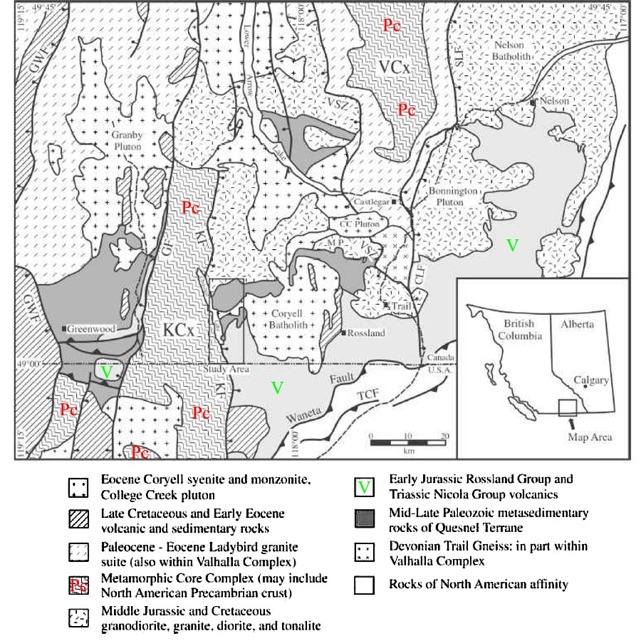
Nature of the basement to Quesnel Terrane near Christina
Lake, southeastern British Columbia S.L. Acton, P.S. Simony, and L.M. Heaman,
Can. J. Earth Sci., 39(1), p. 65-78
The character of the Paleozoic basement of Quesnel Terrane and the position
of the terrane accretion surface that separates Quesnel and Kootenay terranes
from rocks of the ancient North American margin are subjects of debate.
To address these problems, detailed mapping and UPb geochronologic
studies were carried out in the Christina Lake area to define the relationship
of the Mollie Creek assemblage, Josh Creek diorite, and Fife diorite to
similar lithologies in the Greenwood Grand Forks and Rossland regions,
and to place limits on the ages of regional deformation and local position
of the terrane accretion surface. Deformed metasedimentary rocks of the
Mollie Creek assemblage may correlate with sedimentary rocks of the Pennsylvanian
to Early Triassic Mount Roberts Formation in the Rossland area. The
Mollie Creek assemblage is intruded by the foliated Late Triassic
Josh Creek diorite. The Josh Creek diorite and Mollie Creek assemblage
have been deformed together as a result of phase two deformation, following
the intrusion of the Josh Creek diorite in the Late Triassic and prior
to the intrusion of the Fife diorite and deposition of the overlying
Rossland Group in the Early Jurassic. Based on relative age, structural
position, and lithological similarities to other units within Quesnel
Terrane, the Mollie Creek assemblage, Josh Creek diorite, and Fife diorite
are a part of Quesnel Terrane and lie above the terrane accretion surface
in theChristina Lake area. Therefore, Quesnel Terrane does not unconformably
overlie basement rocks of known North American affinity in this region.
Relative
disposition allochthonous and pericratonic terranes according to
Acton et al. - cordchris1.jpg
Distribution
of North American Precambrian crust within the Quesnel Terrane of the Southern
Canadian Cordillera - cordchris2.jpg
Geological
section across the Quesnel Terrane showing the horst structure of the Grand
Forks - Kettle River Complex - cordchris3.jpg
What do the isotopic characteristics of Cordilleran terranes tell us about their origin?
Patchett, P. J. and Gehrels, G. E, 1998. Continental influence of Canadian
Cordilleran terranes from Nd isotopic study, and significance for
crustal growth processes. Journal of Geology. 106, 3, 269-280.
Comment
- Nd isotopic data are presented for rocks of the terrane assembly that
lies inboard of the Stikine terrane in the Canadian Cordillera of
British Columbia and Yukon. These are, from most inboard outward:
Cassiar,
Kootenay, Slide Mountain, Quesnel, and Cache Creek terranes. They
are regarded as documenting a transition from terranes whose evolution
was closely tied to that of the North American continental margin
out to far-traveled oceanic terranes. The results emphasize sedimentary
rocks as indicators of tectonic position of the crustal fragments.
Sedimentary
rocks of the Cassiar and Kootenay
terranes show a strong connection to miogeoclinal sediment sources.
Argillites of Pennsylvanian-Permian age from a paleontologically
controlled section in the Slide Mountain terrane
are also consistent with sediment sources in the North American miogeocline.
Igneous
rocks of the Slide Mountain, Quesnel, and
Cache Creek terranes show
juvenile oceanic or arc origins based on
epsilonNd
values between +3 and +10, and are essentially identical with published
results.
Cache Creek and
Quesnel terranes also contain
sediments
with positive epsilonNd values, suggesting a juvenile, ultimately
volcanogenic, origin. Both terranes, however, also contain some
Triassic
and apparently Pennsylvanian-Permian sedimentary rocks with negative epsilonNd
values between -5 and -7, like those of Devonian to Jurassic sedimentary
rocks of the North American miogeocline.
Possible explanations include proximity to sources of North American terrigenous
sediment, expected in Triassic time, or very far-traveled fine-grained
sediment in the form of hemipelagic clay or eolian dust for older samples.
The addition of a continental sedimentary component to wide areas of the
Cordillera represents an important point of comparison to Proterozoic orogens,
where this component affected the isotopic signatures, but usually cannot
be separately identified due to intense reprocessing during orogenesis.
Cui, Y.
and Russell, J.K. 1995. Nd-Sr-Pb isotopic studies of the southern Coast
Plutonic Complex, Southwestern British Columbia. BGSA, 107, 2, 127-138.
Abstract
- Plutonic and volcanic rocks have EpNd values of +4.2 to +8.9. There
are no significant variations in Nd or Sr isotopic composition with rock
type or age. Many intrusions have isotopic compositions and TDM ages consistent
with the combined effects of melting of mantle and mixing with subordinate
istopically juvenile terranes, e.g. Wrangellia.
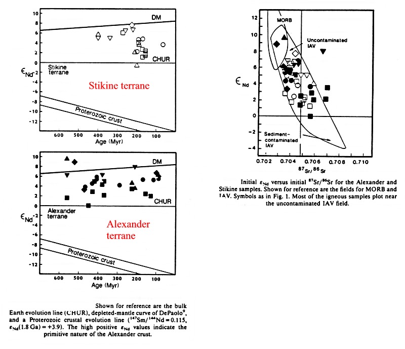
Samson, S.D., et al. 1989. Evidence from neodymium isotopes for mantle contributions to Phanerozoic crustal genesis in the Canadian Cordillera. Nature, 337, 705-709.
EpsilonNd characteristics of rocks from the Stikinia and Alexander terranes - cord2samson1.jpg
The age and tectonic environment of the rocks of the Stikinia terrane
Johannson-G.G.; Smith-P.L.; Gordey-S.P.,
1997. Early Jurassic evolution of the northern Stikinian Arc: evidence
from the Laberge Group, northwestern British Columbia. Canadian-Journal-of-Earth-Sciences.
34, 7, 1030-1057.
Abstract: This study
resolves fundamental questions concerning the age, provenance, and depositional
history of Laberge Group strata in the Whitehorse Trough. The Jurassic
Inklin Formation straddles the Stikine and Cache Creek terranes along much
of the length of the Whitehorse Trough. Ammonite biochronology indicates
an age range of early Sinemurian to late Pliensbachian
and provides the temporal framework for interpreting basin history. Strong
temporal trends in both paleocurrent patterns and sandstone-conglomerate
petrofacies allow definition of three discrete phases in basin-fill history.
Stable tectonics characterized by relative volcanic quiescence and low
sedimentation rates prevailed during the Sinemurian.
Sinemurian sandstone-conglomerate petrofacies record a transitional-arc
provenance derived from erosion of the Upper Triassic
volcanic pile, flanking coastal sediments, and arc
roots of Stikinia to the southwest. During the early
Pliensbachian, arc dissection was interrupted by a major magmatic
episode with widespread rejuvenated volcanism that caused a strong provenance
shift to volcanigenic sources, indicating derivation from a largely undissected
Stikinian arc. Southwest-derived, northerly longitudinal paleoflow during
the Sinemurian changed to opposed bidirectional
radial or transverse paleoflow systems in the early
Pliensbachian. Cannibalism of broadly coeval basinal strata and/or
reflected sediment gravity flows were the result of episodic growth of
a
mobile outer forearc rise, initiating southwest-directed
paleoflow systems during the early Pliensbachian
and
the possible development of a ridged forearc phase. U-Pb dates of 186.6
-1/+-.5 and 186 +/- 1 Ma from a granite clast and tuff unit, respectively,
of the Kunae Zone (early late Pliensbachian)
and sandstone-conglomerate petrofacies indicate a late
Pliensbachian depositional regime dominated by tectonic controls.
The influx of granitic detritus indicates a rapid transition to a
fully dissected arc provenance, where accelerated uplift of segments
of the arc massif, accompanied by intra-arc strike-slip faulting, resulted
in rapid arc dissection and unroofing of comagmatic Pliensbachian
plutons.
The Cache Creek Terrane
Ghent, E.D., Erdmer, P., Archibald, D.A., and Stout, M.Z., 1996. Pressure-temperature and tectonic evolution of Triassic lawsonite-aragonite blueschists from Pinchi lake, British Columbia. CJES, 33, 800-810.
Hrudey-M-G; Struik-L-C; Whalen-J-B,
1999. Geology of the Taltapin Lake map area, central British Columbia.
In: Cordillera and Pacific margin/ Interior Plains and Arctic Canada--Cordillere
et marge du Pacifique/ Plaines interieures et regions arctiques du
Canada.
Abstract: : The Taltapin Lake map
area (93 K/6) is characterized by Permian to Jurassic Sitlika assemblage
volcanic and sedimentary
rocks, the Late Triassic-Middle
Jurassic Taltapin metamorphic complex of mainly amphibolite and strongly
foliated to gneissic diorite, and Jurassic diorite to granite plutons of
the Stag Lake and Francois Lake suites. Tertiary Ootsa Lake and Endako
groups blanket older units, and are vesicular andesites, and basalts. Ootsa
Lake Group also contains dacite, rhyolite, and rhyodacite breccia. The
Permo-Triassic mafic Volcanic unit, and Triassic-Jurassic Eastern clastic
unit of the Sitlika assemblage appear distinct lithologically, metamorphically,
and structurally from Taltapin
metamorphic complex units. The
Sitlika assemblage separates rocks of Cache Creek and Stikine terranes,
hence Taltapin metamorphic complex is interpreted as a metamorphic equivalent
of Stikine Terrane, rather than metamorphosed Cache Creek Terrane. The
Taltapin metamorphic complex was deformed and metamorphosed prior to the
Late Triassic. It was further metamorphosed and juxtaposed with Sitlika
assemblage between the Late Triassic and Middle Jurassic.
Orchard-M-J; Struik-L-C; Taylor-H; Quat-M, 1999. Carboniferous-Triassic
conodont biostratigraphy, Nechako NATMAP Project area, central British
Columbia. In: Cordillera and Pacific margin/ Interior Plains and
Arctic Canada--Cordillere et marge du Pacifique/ Plaines interieures et
regions arctiques du Canada. Current
Research - Geological Survey of Canada. 97-108.
Abstract: Fifty-seven new conodont
collections from the Nechako NATMAP area contribute to a conodont biostratigraphic
framework for the region. Most collections are from the Pope unit of the
Cache
Creek complex and are early Late Carboniferous
(Bashkirian-Moscovian) to Middle Permian (Wordian). The most extensive
carbonate
buildup is Bashkirian-Moscovian, whereas latest Carboniferous to Permian
limestone is much less common and Middle Permian
buildups are known only in the north. The Sowchea
clastic-volcanic
unit is Late Permian to Late Triassic (Norian);
it includes unique records of (?)Changshingian, Griesbachian, and Smithian
fauna, and the first records of Middle Triassic Tethyan
Gladigondolella in Canada. At two widely separated localities, breccia
containing mixed conodont faunas show that Paleozoic and Triassic strata
were reworked during or after the Late Triassic.
Late
Triassic conodonts are also reported from the Tezzeron unit and adjacent
Takla
Group of the Quesnellia terrane.
The 'exotic' nature of Stikinia and WrangelliaAberhan, M. 1999.Terrane history of the Canadian Cordillera: Estimating amounts of latitudinal displacement and rotation of Wrangellia and Stikinia.Geological-Magazine. 136, 5, 481-492.
Aberhan, M, 1998. Paleobiogeographic
patterns of pectinoid bivalves and the early Jurassic tectonic evolution
of western Canadian terranes. Palaios. ; 13(2): 129-148.
Asbtract: Utilizing new data
from western Canada, the biogeography of Early Jurassic pectinoid bivalves
along the eastern paleo-Pacific margin has been analyzed qualitatively
and quantitatively. The studied areas range from the Andean Basin in the
southern hemisphere to the Sverdrup Basin of Arctic Canada and include
major allochthonous terranes of western Canada. While the Andean Basin
exhibits a mixed bivalve fauna of austral, bipolar, and low latitude-East
Pacific forms, pectinoid bivalves from the Canadian craton are characterized
by a high percentage of boreal and bipolar taxa. The western Canadian allochthonous
terranes Wrangellia and Stikinia show a mixed influence of low latitude-East
Pacific and boreal/bipolar forms until Pliensbachian times. During the
Toarcian/Early Aalenian, taxa typical of low latitudes disappeared. This
pattern of a latitudinally differentiated Early Jurassic bivalve fauna,
which apparently is climatically controlled, seriously undermines
the hypothesis of a uniform West American bivalve province. Based on diversity
gradients, similarity coefficients, cluster analyses, and distributional
patterns of characteristic taxa, biogeographic data have been used to constrain
the latitudinal positions of Wrangellia and Stikinia through time. During
the three analyzed time intervals (Hettangian/Sinemurian, Pliensbachian,
and Toarcian/Early Aalenian), both terranes were in the northern hemisphere
and in the eastern paleo-Pacific. During all of the Early Jurassic, Wrangellia
and Stikinia were close together and were moving northward. Paleolatitudes
corresponding to those of the Western Canada Sedimentary Basin in Alberta
were not reached before Toarcian times. By the end of the Early Jurassic,
both terranes were in much the same latitudinal position relative to the
craton as they are now. Consistent with biogeographic
patterns are Early Jurassic latitudinal displacements of approximately
1300 km.
Harris-M.J.;
Symons-D.T.A.; Blackburn-W.H.; Hart-C.J.R., 1997. Paleomagnetic and geobarometric
study of the mid-Cretaceous Whitehorse Pluton, Yukon Territory. Canadian-Journal-of-Earth-Sciences.
34, 10, 1379-1391.
Abstract:
This is the first of several Lithoprobe paleomagnetic studies underway
to examine geotectonic motions in the northern Canadian Cordillera. Except
for one controversial study, estimates for terranes underlying the
Intermontane Belt in the Yukon have been extrapolated from studies in Alaska,
southern British Columbia, and the northwestern United States. The
Whitehorse Pluton is a large unmetamorphosed and undeformed tonalitic body
of mid-Cretaceous age ( ~112 Ma) that was intruded into sedimentary units
of the Whitehorse Trough in the Stikinia terrane. Geothermobarometric estimates
for eight sites around the pluton indicate that postmagnetization tilting
has been negligible since cooling through the hornblende-crystallization
temperature and that the pluton is a high-level intrusion. Paleomagnetic
measurements for 22 of 24 sites in the pluton yield a well-defined characteristic
remanent magnetization (ChRM) direction that is steeply down and northwards.
The ChRM direction gives a paleopole of 285.5 deg;E, 81.7 deg;N (dp/inf
= 5.3 deg;, infm/inf = 5.7 deg;). When compared with the 112 Ma reference
pole for the North American craton, this paleopole suggests that the northern
Stikinia terrane has been translated northwards by 11.0 +/- 4.8 deg; (1220
+/- 530 km) and rotated clockwise by 59 +/-17 deg. Except for an
estimate from the 70 Ma Carmacks Group volcanics, this translation and
rotation estimate agrees well with previous estimates for units in the
central and southern Intermontane Belt. They suggest
that the terranes of the Intermontane Belt have behaved as a fairly coherent
unit since the Early Cretaceous, moving northward at a minimum average
rate of 2.3 +/- 0.4 cm/a between 140 and 45 Ma.
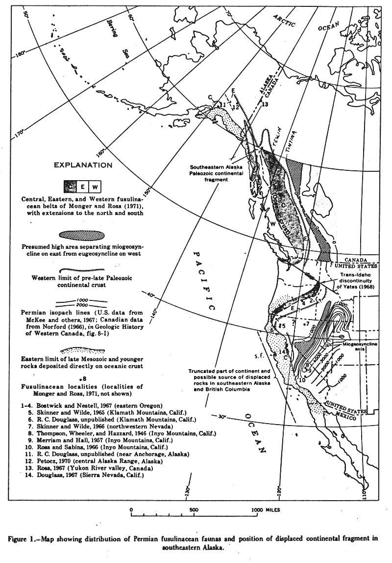
Distribution of Permian fusilinacean faunas in the Canadian Cordillera - cord2fusil1.jpg
Mineralization
Gabrielse-H., 1998. Geology of Cry
Lake and Dease Lake map areas, north-central British Columbia. Bulletin-of-the-Geological-Survey-of-Canada.
504, 1-147.
Abstract: Cry Lake and Dease Lake
map areas include six well defined terranes each characterized by
distinctive lithological assemblages of different ages, structural styes,
and contained mineral deposits. Miogeoclinal strata
of
Ancestral North America range in age from Late Proterozoic to Early
Mississippian. They have been intruded by voluminous Mesozoic and
Cenozoic granitic rocks, in places associated with tungsten, lead,
and zinc occurrences. The Slide Mountain Terrane
contains Devonian to Permian rocks typical of oceanic and island
are environments. The Kootenay(?) Terrane
is characterized by strongly tectonized, mainly weakly metamorphosed,
siliceous strata. Ultrabasic rocks have potential for jade occurrences
and a few vein deposits of lead, zinc, gold, and silver have been
explored. Rocks assigned to Quesnellia
are of Mesozoic island arc lithologies. In one locality, granodiorite
is host to an important copper deposit. Low grade nickel and chromite
deposits are hosted by an Alaskan-type ultramafic body. The Cache
Creek Terrane is dominantly oceanic in lithology but includes some
assemblages of island arc or rift affinity. The terrane ranges in
age from Devonian through Early Jurassic. Ultrabasic rocks host jade and
asbestos deposits and are spatially related to numerous placer gold deposits.
The island arc or rift volcanics host a large zinc and copper volcanogenic
sulphide deposit. Rocks of Stikinia represent
upper Paleozoic to Lower Jurassic island arc assemblages which are overlain
by upper Mesozoic to Recent sedimentary and volcanic overlap assemblages.
Copper, molybdenum, gold, lead, and zinc occurrences are found in the volcanic
and plutonic rocks. Coal occurs locally in overlap sedimentary rocks.
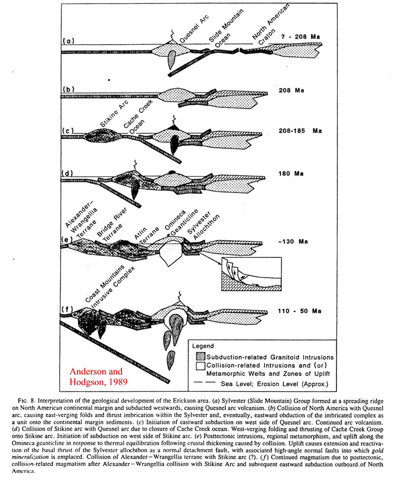
The accretionary history of the Canadian Cordillera
Anderson, P.G.and Hodgson, C.J.,
1989. The structure and geological development of the Erickson gold mine,
Cassiar District, British Columbia, with implications for the origin of
mother-lod-type gold deposits. CJES, 26, 12, 2645-2660.
Comment - Slide Mountain ocean
separates Quesnel arc from continent; amalgamation at 208 = Triassic Jurassic
boundary; amalgamation of Stikine arc above an east dipping subduction
zone at 180 = late Early Jurassic; amalgamation of Alexander at 130 = early
Early Cretaceous.
The accretionary history of the Canadian Cordillera, Anderson and Hodgson, 1989 - cord2hodg1.jpg
The accretion of Wrangellia at the southern end of the Cordillera
On the following terrane map note the convergence of Wrangellia with Quesnellia at the expense of Stikinia at the southern end of the Cordillera.
Terrane Map of the Canadian Cordillera - cord2terr1.jpg
The following figure illustrates the structural/stratigraphic relationships between Wrangellia (Skagit gneiss), Stikinia (Hozameen), and the Methow arc built on the western leading edge of Quesnellia.
The Skagit-Methow crustal section at the southern end of the Canadian Cordillera - cord2meth1.jpg
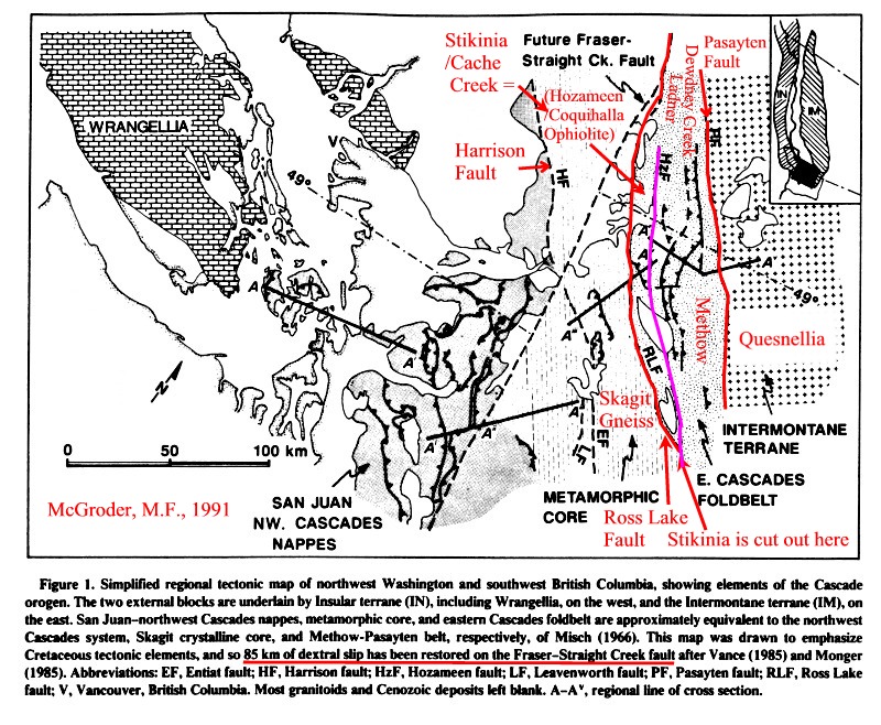
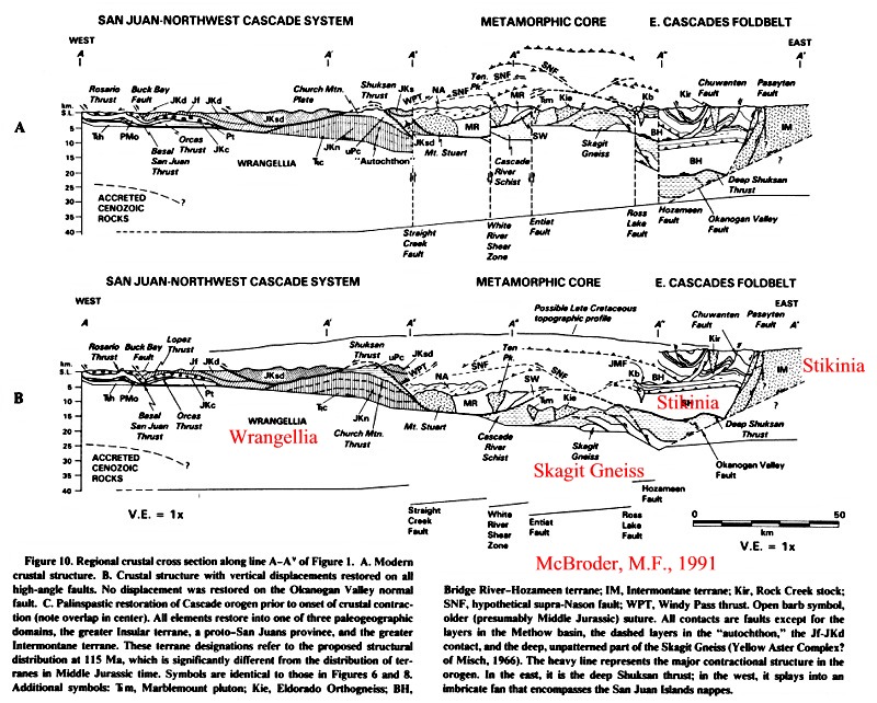
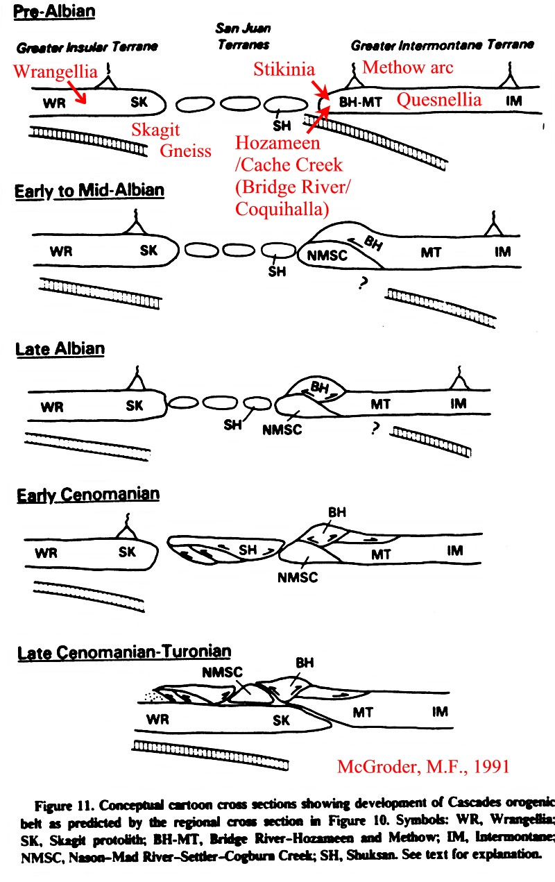
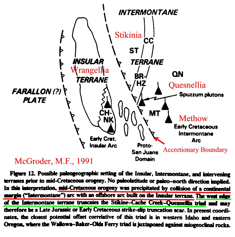
The following figures illustrate the relationship between Wrangellia, Stikinia and Quesnellia in the Cascade region of Washington and British Columbia at the southern end of the Canadian Cordillera, as interpreted by M.F. McGroder (BGSA, 1991).
Regional tectonic map of the southern Canadian Cordillera/northwestern Washington - cord2mcgrod1.jpg
Regional cross section across the Southern Cordillera - cord2mcgrod2.jpg
Cross sections illustrating the development of the southern Canadian Cordillera - cord2mcgrod3.jpg
FIGURES
Structural Provinces of North America.
RETURN TO:
Click here to return to beginning.