Click here to go to 'Figures/Overheads' section.
Click here to return to course outline.
Click here to return to W.R. Church's home page.
Click here to return to Earth Science course list.
THE UNIVERSITY OF WESTERN ONTARIO
LONDON CANADA
Final Examination - April 18th 1998
Time: 3 Hours Intramural
GEOLOGY 300B
LECTURE SECTION
(70%)1) Write illustrated notes and/or diagrams on ONE of the following topics (20%):
a) Show diagramatically the distribution and movement of sodium in the various reservoirs of the present-day Earth System.
b) Explain the relationship between partition coefficients, compatibility, fractionation, and the formation of the Earth’s continental crust.
c) Explain how the concept of (in)compatibility is used in interpreting element variation diagrams, including spidergrams; provide examples.
d) How are stable isotopes used as ‘stratigraphic tools’?
e) How do the isotopes of the element pairs Sm-Nd and Rb-Sr differ in their geochemical properties, and how is Sm-Nd used in making geological interpretations?
f) Explain how the western margin of North America has grown since the Late Proterozoic. What kind of material constitutes the Cache Creek suspect terrane; what kind of arc is Stikinia; and what do the Stuart Fork terrane and Great Valley sequences represent?
g) What geological processes were operative in the formation of the Appalachian system of eastern North America? What do the Exploits and Gander Lake terranes represent?
2) Write illustrated notes or diagrams on TWO of the following topics (50%):
a) Explain the supposed relationship between supercontinents and continental marine transgressions. Name three of the North American trangressions.
b) The Archean - Lower Proterozoic boundary is marked by important changes in lithology, geochemistry, and terrane organization. Describe and provide an explanation(s) for the changes.
c) How would the Archean of the Superior Province compare with the Phanerozoic Cordilleran system?
d) Describe the lithologic and isotopic (age) subdivision of the Grenville Province.
e) What does seismic tomography tell us about the structure of the Superior and Grenville Provinces. What are the seismic and lithologic variables used in the analysis of the tomography.
LAB SECTION (30%)
3) Answer ONE of the following questions.
a) Explain the format (organization) of Vector, Raster, Attribute Value, and Palette files. What are .DOC files and what necessary information do they contain pertinent to Vector and Raster images?
b) The IDRISI module XYZIDRIS converts an xyz text file into a vector image file. What information is contained in the xyz file, what other information may or may not be necessary to generate a meaningful image, what kind of vector file is generated, and how may you convert the vector image to a raster image.
Explain the concept of a Boolean image.
c) Fieldlog is a relational database. As a geologist and/or geophysicist explain how you would organise and manipulate your data in Fieldlog, and subsequently generate various kinds of maps in vector or raster drawing software such as Autocad and Idrisi.
FIGURES
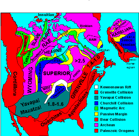
Structural Provinces of North America.
RETURN TO
:Click here to return to beginning.
Click here to return to course outline.