INSTRUCTIONS:
Answer
the questions in Parts I, II and III.
All
questions to be answered in the examination answer booklet.
Write
double-spaced, do NOT use a
faint pencil or a Red pen. Neatness
counts.
This
examination is worth 40% of the final grade for the course.
This
examination totals 100 points.
Part
I has 3 questions and is worth 30 points (10 points per question, choice of 3
out of 6 questions)
Part
II has 2 questions and is worth 20 points (10 points per question, choice of 2
out of 4 questions)
Part
III has one question and is worth 50 points (choice of 1 out of 3 questions).
Part I - Short Answers based on the textbook and lectures
Answer three of the following
questions. Each is worth 10
points. Do not answer more than two
questions.
1.
Based on the Pythagorean Theorem, develop the Distance Theorem (from Chapter 13 - Distance)
2.
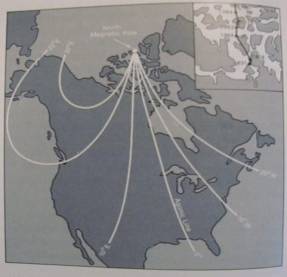
Explain
the following Figure and Inset map (from Chapter 12 - Direction)
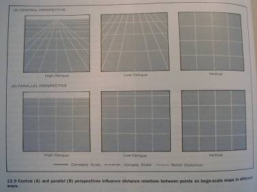
3. Explain the following Figure
(from Chapter 13 - Distance).
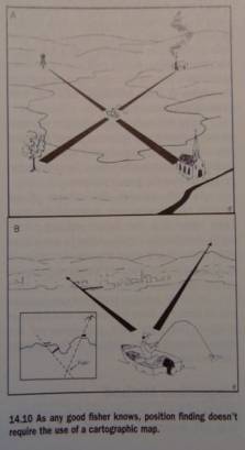
4.
Explain the following Figure.
(from Chapter 14: Compass and
Maps)
5.
Establishing
Your Position — using the Inspection Method (by Distance Estimation or by
Resection). Explain how done. (from Chapter 14: Compass and Maps)
6.
Establishing
Your Position — using the Altimeter Method (by Linear Feature or by Sight
Line). Explain how done. (from Chapter 14: Compass and Maps)
Part II- Short Answers based on the
lab/assignments
Answer two of the following
questions. Each is worth 10
points. Do not answer more than two
questions.
7.
Discuss
pros and cons of the “image based plane table” field mapping method we used in
Gibbons Park.
8.
Compare the map component in Assignment 1 to the CTN in Assignment 3.
9. Describe the ways a compass was used as part of Assignment 4.
10. Briefly review two major
cartographic (mapmaking) principles that were mentioned in the lab for
“Assignment 3: Design and
Implementation of a Cartographic Travel Narrative”..
Part III- Essay
Write a well organised/stuctured 5-6 page doublespaced essay on one of the following topics. First
make an outline, and then write your essay.
Submit neat final versions of both your outline and your essay. Focus on key terms. Include examples and diagrams if
relevant. Write simple accurate
sentences. Use a pen. The essay is worth 50 points.
11.
Essay Title: The section on
Prepping Maps for GPS Use in the chapter on “GPS and Maps” (Chapter 15)
12.
Essay
Title: “Time and Maps” (Chapter 8)
13.
Essay Title: “Establishing
Your Position”. (This section
appears in Chapter 14: Compass and Maps
).