INSTRUCTIONS:
Answer
the questions in Parts I, II and III.
All
questions to be answered in the examination answer booklet.
Write
double-spaced, do NOT use a faint
pencil or a Red pen. Neatness counts.
This
examination is worth 20% of the final grade for the course.
This
examination totals 100 points.
Part
I has 2 questions and is worth 30 points (15 points per question, choice of 2
out of 4 questions).
Part
II has 2 questions and is worth 30 points (15 points per question)
Part
III has one question and is worth 40 points (choice of 1 out of 3 questions).
Part I - Short Answers based on the textbook and lectures
Answer two of the
following questions. Each is worth 15
points. Do not answer more than two
questions.
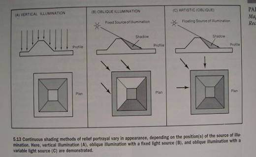
1. Explain the following Figure in Chapter 5 - Landform Portrayal.
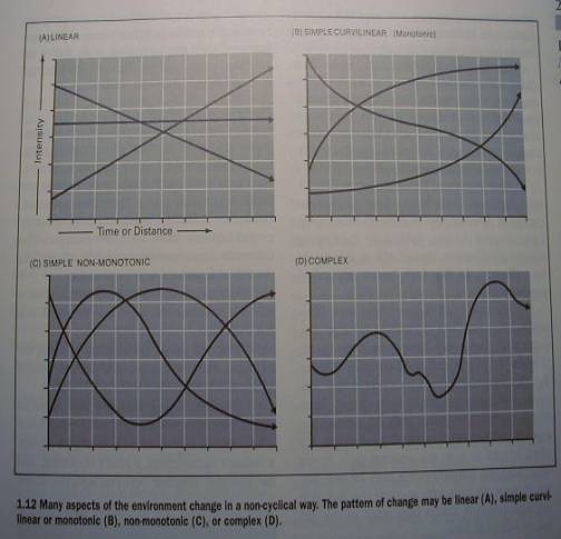
2. Explain and provide examples for the following Figure (from Chapter 1
- The Environment to be Mapped)
3. What are Object-Oriented (Data) Models and what are Location-Oriented
(Data) Models? (from Chapter 2 - Geographical Data)
4. Provide a brief explanation accompanied by a schematic diagram of the
difference between Interpolation and Extrapolation (from Chapter 2 -
Geographical Data)
Part I I- Short Answers based on
the lab/assignments
Answer the two of
following questions. Each is worth 15
points.
5.
Briefly describe an alternative to the planned trip you proposed in
Assignment 1. Base it on similar
guidelines.
6.
What aspects of Image Interpretation did you learn from Assignment No. 2
?
Part III- Essay based on the textbook
Write a well
organised/stuctured 4-5 page
doublespaced essay on one of the
following topics. First make an outline, and then write your essay. Focus on key terms. Include examples and diagrams if relevant. Write simple accurate sentences and be
neat. Use a pen. The essay is worth 40 points.
7. Essay Title: “Keys to
Image Interpretation”. (This
section appears in Chapter 24 : Image Map Interpretation).
8 Essay Title: “The
five primary activities of the abstraction process that leads to a map”. These activities are main heading in Chapter
3 - Map Abstraction Process.
9. Essay Title: “Provide
a Synopsis of Chapte 1 The Environment to be Mapped”