Lec 10: GPS
Basic Field
Mapping
In advance
of this week’s “Labs at the Park”
Field
Mapping
Plane Table Mapping
Rationale
To map w/out
having to ‘stomp, clamber and scamper’ all over the place
We will use
an info rich ImageMap as a backcloth
Take
advantage of old and new low-end (‘personal’) mapping methods
The old
fashioned way
*Blackboard*
A modern
alternative
The process
starts with acquiring a suitable image
London
Ikonos data
Next stages:
Layout, Grid
Reference, Scale, North Arrow
Print (plus
Laminate)
Do fieldwork
- ray in features
* Field
Mapping1 and 2 (“key” digital photos)
Final stages
Process
results manually or digitally
Result: My
field map..!
Conclusion
and Recommendation:
Use a
combination of old and new,
analog and
digital,
technologies
Example:
acquire
image —> digital processing —> print —> xerox —> laminate
—> fieldwork
—> enter
into computer —> process —> print —> xerox
Field
Exercises
Orienting the ImageMap
Note: Orient
by co-visible features
Don’t use North Arrow (it could be wrong, unlike the features)
Locating your position
w/compass
and field visible objects
Locating the position of an object
Co-visible
objects
These
replace the points on the base line
and, hence, the need for a base line!
Imagemap-only
visible object
Use for orientation
and navigation
Field-only
Visible object
This is what
we want to map!
Example: The Benches along the
path....
Mapping Field Visible objects —
w/out GPS
w/GPS
Co-Visible
or Baseline points only
(assuming we want to avoid visiting each mapped point)
Announcements
Final Exam
Full brief
next week: Format and Mock Final
Non
cummulative:
Chapters:
12-15, D, 8, 9, 20
Timing:
Easter Monday
As opposed
to Good Friday
Do we need
or want an ombudsman meeting?
Excerpts
from the hilarious Text Box 15.1: cell
Phones: A Call from the Wild
“ I looked
at a big pile of gear and I looked at the phone,” a climber said. “And the
phone was a helluva lot lighter”.
“Press 1 if
you’re a bozo...”
“Before they
even caught anything, Penney recalls, the brokers were on the cell working the
markets in new York and Singapore. Penney should have thrown his friend in as
bait.”
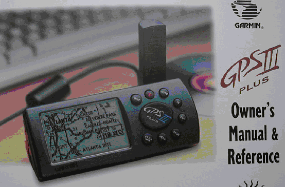
GPS
TOC
GPS =
Computer
The Main
Functional Components are:
antena
micro-processor (‘computer’)
memory
port to computer
(and hence a
gateway to database, applications, and visualization)
GPS and
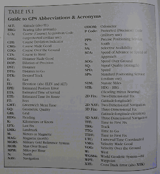
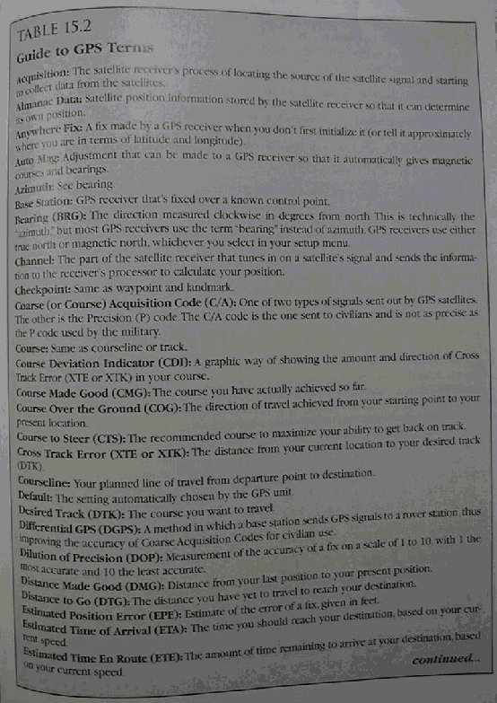
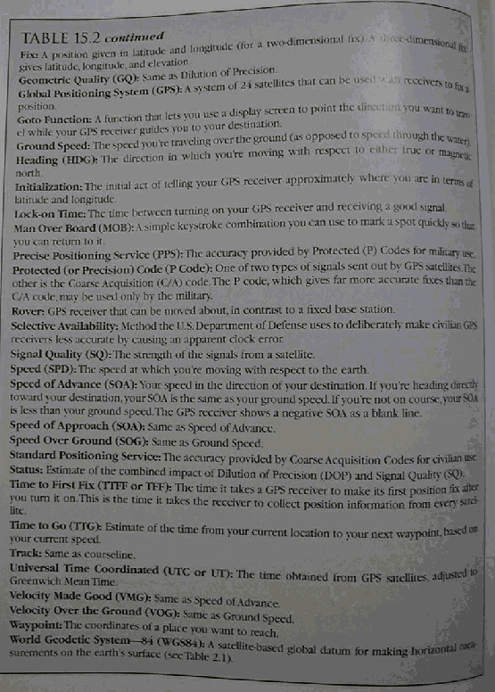
Navigation terminology
* Table 15.1
* Table
15.2a
* Table
15.2b
*
Interface (Fig 15.1)
* Fig
15.2substA
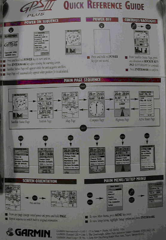
* Fig
15.2substB
Tables and
Equations
The GPS
makes use of tables & equations stored in its database
to give the
user a variety of information formats
to
communicate with computer software for upload and download
Datum
Even
handhelds typically hold tens of datums in memory
It is very
important to match the GPS datum with that of the map being used:
“If you’re
not using a map based on WGS84 (the default datum), the positional discrepancy
between your map datum and WGS84 will create positioning errors beyond those
associated with the stated accuracy (EPE) on your receiver...as much as 100
meters in the U.S. and 600 meters worldwide.”
Grids
The
geographical grid (Lat-Long) is usually the default,
UTM is found
in all units
and others
may be available as well
Declination
GPS can
report direction with respect to True North
or Magnetic
North
taking local declination into account
note: the
GPS isn’t a magnetic compass
Celestial
Extras
GPS provides
sunset and sunrise data for all locations
Question: Who cares?
Databases
Receivers of
all types (handhelds, mid-size units for vehicles, etc) can hold different databases,
such as:
generic (eg. DCW), Topographic, Road/Travel Maps, Aeronautical maps,
Marine charts, etc.
as well as custom user spatial databases
the
databases can be stored in fixed or removable memory (memory cards, sticks,
etc.)
These maps
can be viewed:
on the
screens of some units
Black and White and Color (varying numbers of colors and color palettes)
on a
computer
e.g. GIS spatial databases (SDBs)
remote sensing imagery or imagemaps
Field
Applications
Use GPS to
Orient Map
easy when
you can see a co-visible distant landmark (on both the ground and the map)
how done?
how
different from when we didn’t have the GPS (in Chapter 14)?
unwieldy,
but possible, otherwise
when point
is visible on map but not ground
when point
is visible on ground but not map
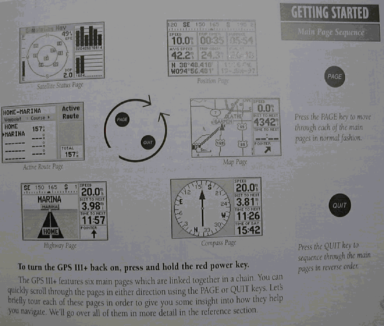
Use GPS to
Find Your Position
This is what
GPS give us effortlessly....
* Fig. 15.3
- 15.7 (substituted by Pazner)
our
hand-held units claim an accuracy of up to 15 meters
(many ways
to measure accuracy - as the text points out)
Accuracy is
less in kinetic mode
ie. when the
unit is moving
Question: Why?
Less need
for DGPS by common users
when S/A is
diabled
possibility
of regional (if not global) DGPS service-providers network
providing
services to common handhelds
to increase
fix accuracy (e.g. to 3 meters)
Vertical
accuracy is three times worse than horizontal accuracy
up to 46
meters max (which won’t be achieved 95% of the time)
Question: What’s a possible reason for the asymmetry
in horizontal versus vertical accuracy?
In many
cases the elevation reading is useless
due to the
large vertical error
and an
altimeter is recommended
Use GPS to
Find Distant Position
No can
do....
(for a feature that isn’t on a map)
Caveat:
without an additional gizmo:
the coupled
Compass EDM GPS ‘dealie’
Use GPS to Plan
Route
Simple/primitive
GPS units are not too useful for this task
(and this is what the text talks about here)
However,
units that have map displays, stored spatial databases
and/or computer linking capabilities
can be used
to plan a route
(note: the text should (in the next edition?...) make this distinction,
now that these two types of units are commonly available)
Use GPS to
Follow Route
“The awesome
power of GPS is revealed when following routes.”
The next
headings describe the various types of route following information that are
provided
Where Am I
Going?
Enter the
destination (via coordinates or
graphically, if you can)
and “press
the GOTO” button...
You can
break your trip up into legs by using a number of landmarks (or “waypoints” -
WPTs)
GOTO will
provide you with the distance and direction information from one WPT to the to
the next
*** Refer back to Fig. 5.3 - 5.7 (substituted by
Pazner)
Where Have I
Been?
Progress
along a (any) moving path
is provided
by a breadcrumb trail
note that
route information can be saved
Question: breadcrumbs will appear even when you are
stationary — Why?
How Am I
Doing?
Compass and
highway pages are designed to show progress along a route
Refer back
to Fig. 5.3 - 5.7 (substituted by Pazner)
often
include course deviation indicator (CDI) graphic display that shows
cross track
error (XTE or XTR) which is very useful for guiding you back on course
and other
time and speed info:
eg. speed
(SPD) and velocity made good (VMG)
and ETE
(estimated time en route) and ETA
Question:
how different?
more useful
in vehicles than on foot
note that
these are “as the crow flies” (underestimated) distances
also on foot
there is the battery depletion issue (so use sparingly/intermittently)
The thing
(GPS) may beep at you when you approach a waypoint, turn (intersection),
destination, etc.
How Do I Get
Back?
Most GPSs
have a backtrack function for retracing the route back out
and an MOB
function which marks an MOB waypoint
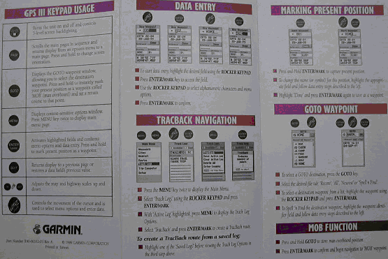
GPS
Limitations
GPS is a
mechanical device - doesn’t think or feel, and consequently:
“...it can’t
tell you which route is the quickest, most interesting, least effort, most
aesthetic, or least comfortable..”
Linking GPS
to Maps
Paper Maps
taking along
a map and a field notebook
Marrying
“the old with the new” is a functionaly potent combination
Digital Maps
there are
tremendous advances to marrying a GPS with automated cartography or GIS
two main
options:
integrated graphic display
hookup to a computer/notebook/hand-held
* Fig. 15.10
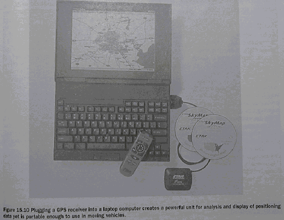
Example: Our Portable GPS/GIS System for Cartographic
Visualization
Getting
spatial data into Integrated GPS Receivers
Spatial
database loaded by manufacturer
into GPS
memory
on CD
Spatial
database loaded by user
into GPS
memory from computer CD/internet
into GPS
memory cards from computer CD/internet
* Portable GPS/GIS

* Portable GPS/GIS Close-Up

Keep a
Notebook
Keep Your
Compass
GPS and
Compass are complementary navigational tools, with healthy tradeoffs between
their pros and cons
“If you
choose to ignore this advice, then we can only echo Edward Abbey’s suggestion
in The Journey Home:
“Carry water. Avoid the noonday
sun. Try to ignore the vultures. Pray
frequently”.
Warning to
GPS Novices
“You may
know exactly where you are and where you want to go but still be lost.”
Questions:
How come?
To prevent a
problem:
leave
information of where you are going, and/or
take a
communications device along
Cell phones
may not cut it
future
satellite based system will
Prepping
Maps for GPS Use
The problem
Older or
simple GPS lack a graphic map display
Older maps
lack GPS grids
This problem
is being alleviated by changes on both sides
However, at
times
we may still
need to work with GPS coordinates and old (non-GPS-ready) maps
Flesh Out
Map Grid
* Fig. 15.11

* Fig. 15.12

Pazner’s corollary: Use thin tick marks, and if you must do a
grid — mute it
Add Grid to
Gridless Map
How Done ?
Two ways
both are a pain...
Create Range
Grid
* Fig. 15.13

Grid-Reading
Aids
Digital
Database
Example: The Tracker and Ruler tools in MFworks
Q: And what else?
Portable
Grid
* Fig. 15.14

* Fig. 15.15

Location-Aware
Devices
Conclusion
“This
positioning technology will soon be altering your life in unimaginable
ways. As a consequence, your spatial
behavior will be safer and more efficient.”
Box. 15.3
New Freedom in the Sky
the concept
of “Free Flight”
Time for Navigation (sub) Unit?
TTFN