Lec 12: Map Accuracy
Geographic Flight Simulation — A free
form discussion
Virtual Georeconnaissance
Quote:

The Readings for Today’s Lecture were:
Ch. 20: Map Accuracy
Comments or Questions?
(General, Lab, Assignment, Readings)
Today’s Lecture:
Map Accuracy
The Course in Review
Map Accuracy
* TOC
Maps are a representation of reality
map accuracy refers to how true a map is to reality
map accuracy is a complex issue
TRUTH OR EFFECTS
“Our big concern
must be to compensate for the
distorting or untruthful aspects of abstraction. This is true of all forms of representation (including mapping)”
Accuracy or Precision?
Accuracy means fidelity to the truth
Precision means “how fine is the
measurement”
therefore high
precision does not guarantee high accuracy
Factors involved in precision
measurement resolution
example: can a
compass measure up to single degrees or tenth of a degree?
repeatability or agreement of multiple
measurements
eg. multiple
measurements taken with a GPS at the same location
the rigor and sophistication of the
measurement process
example: modern
telescope technology (post Hubble), including digital processing to compensate
for atmospheric effects
Types of Accuracy
Positional Errors
horizontal or vertical
Question: Compared to What?
Answer: to US Map Accuracy Standards
refer to Box 20.1
Map accuracy is defined statistically
based on a small sample of locations
dangerous to deduct a specific
instance (a particular location) based on the statistic(s)
positional map accuracy increases as
map scale increases
Conceptual Effects
Question: what is meant by this?
Answer: conceptual (abstract) environmental features
e.g. “forest patch” “corridor”
see Box 20.2
Standards cannot apply to these types
of features
which are quite different from base
map themes such as topography, hydrology, roads, boundaries, and other
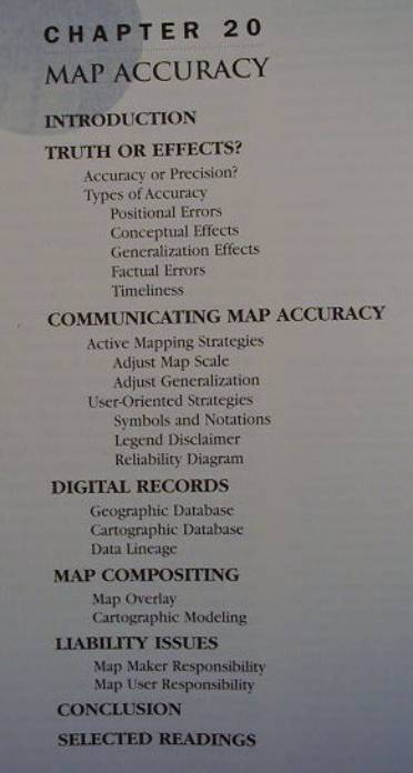
Generalization Effects
The mapping process demands
cartographic generalization
Why?
This data reduction process results in
loss of information and positional distortion
this positional
displacement should be regarded as an effect rather than as error
within the same map a country road may
be less generalized than a more intricate feature, such as a major highway
* Fig 20.1
Factual Errors
Question: What are these? Examples?
Note
that where remote sensing image
processing is concerned
we are dealing with classification
accuracy
errors of
omission and comission
the concept of
“mixels” (mixed pixels)
and sub-cell image processing
Timeliness
maps become “senile” over time...
like milk, maps are best ‘consumed’
when fresh...
note that different features in maps
(esp. digital) may come from variably-aged data
COMMUNICATING MAP ACCURACY
It is important
that the map-maker communicate map
accuracy to the map-user
Active Mapping Strategies
The map-maker tailors the map with map
accuracy in mind
Adjusting Map Scale
if some of the data is inaccurate
relative to the map scale, then the map scale should be decreased
Adjust Generalization
“As a rule, all variables on a map
should be about equally generalized.”
In practice however, base data is
often less generalized than less accurate thematic overlays
therefore avoid
assessing the thematic map’s accuracy based on the base data
User-Oriented Strategies
When map-makers don’t actively
incorporate accuracy considerations in their map design
they at least often take a more
passive route and warn users
three types of warnings
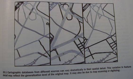
Symbols and Notations
special symbols (explained in the map
legend)
using a symbol fuzziness factor
Legend Disclaimer
placing a disclaimer in the legend
Example: the disclaimer that appears on the screen of the Garmin GPS after
you turn it on:
“Land data is provided only as a
general reference to your surroundings”
In addition
Maps often report the date of map
production
and the source of the data
varying
reputation of mapping agencies
commercial more
suspect
Reliability Diagram
is sometimes included
* Fig. 20.2 provides examples of map
accuracy warnings
DIGITAL RECORDS
digital maps come from secondary and
primary data collection
Geographic Database
Primary data collection by the
map-maker
especially in the age of GPS
has the potential for higher data
fidelity
Primary data can be termed geographic
data
that is compiled into geographic
databases
Cartographic Database
The vast majority of digital spatial
data and databases
Building digital spatial databases is
hard
“Expending vast amounts of time,
energy, and money doesn’t guarantee that a reliable cartographic database will be created.”
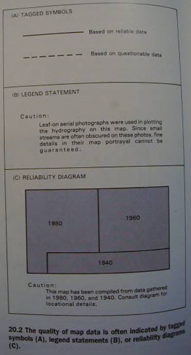
The map accuracy problem is compounded
when in addition to the existing
problems with the data
more error is introduce in the process
of converting this data into digital form
* For example, see Fig. 20.3
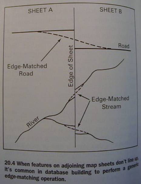
One classic problem
is the edge-matching problem when
creating a ‘seamless digital database’
* Fig. 20.4
Data Lineage
A geneaology for maps
showing their ‘pedigree’
a bit like family trees for people...
Meta-data
Data about the data
standards exist in some countries and
mapping agencies
on how data lineage should be
documented
There are software modules and packages
to deal with cartographic data lineage
eg. David Lanter’s Ph.D. and
subsequent work on the Geolineus
system
MAP COMPOSITING
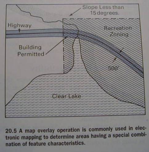
Map Overlay
overlay logic and arithmetic is used
on a number of layers to produce a result
cartographic accuracy suffers from
additive layer error effects
therefore
results must be treated with special caution
* Fig. 20.5
Cartographic Modeling
The problem gets worse when more
sophisticated modeling procedures are used, due to:
selective choice
of data layers that are included in the model
weights assigned
to variables
the mathematical
model itself
Example: the Unversal Soil Loss
Equation (USLE)
E =
2.24 * R * K * L* S* C * P, where
E - erosion (average soil loss), R -
rainfall intensity factor, K - soil erodibility factor, L - length-of-slope, S - steepness of slope
C - cropping management factor, P - prevention practice factor
[http://pasture.ecn.purdue.edu/~aggrass/models/agnps/usle.html]
Sensitivity Analysis
aka Stability Analysis
parameters are slightly changed
and the results
compared
if the results vary wildly, the model
and maps are deemed highly sensitive (unstable)
and should be
given less credibility
LIABILITY ISSUES
facing map-maker and map-user
today often the map-user is also the
map-maker
so both liability issues may pertain
to the same individual or organization
Map-Maker Responsibility
must make “every reasonable effort” to
ensure map or cartographic database quality
must warn user of potential problems
and hazards in using the product
Map-User Responsibility
less well defined
if you are a vendor and market map-use
products
you should be careful and responsible
“Speaking ethically rather than
legally,
you probably have no business using maps if low skill on your part
could harm others or the environment.”
You especially have an obligation to
get beyond “map-as-territory” blinders.
Question: Huh? What does this
mean?...
CONCLUSIONS
Map user should be aware of map accuracy
issues and ask:
“Can I live with the accuracy of this
map in this situation?”, or
“What special care should I take if I
use this map for this purpose?”
Break
The Course in Review
End of Course : )