|
|
|
|
geographic primitives
what are the essential building blocks of geography points, lines, areas and surfaces (from Earickson, 1994) points - can take on a variety of descriptive (metric or other) depending on frame of reference in geometry a point has no size only location, in geography they can refer to cities, individual plants, parks point can be measured in either quantitative or qualitative terms i.e. point representing city has 3 million inhabitants, or it is an industrial city line- has single dimension of length but no width, in geography measure length between places but also measurable quantities of people, info etc areas - bounded by lines, displays of phenomena within areas are called spatial distributions surfaces- display of volume or altitude, they are maps with a third spatial dimension distance- very important concept because it is core to the discipline it is basically a scale that has specific conventions lets illustrate most common distance measure Euclidean distance which is a linear metric scale before we can compute linear distance we need a system of measurement between places on surface of the earth, most commonly used is the Cartesian coordinate system of latitude and longitude
if study area is small we can establish an arbitrary origin and express locations in reference to it
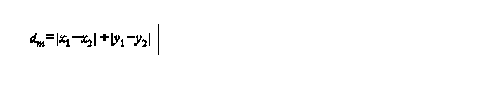
formula is
2 important assumptions
1) assume Euclidean geometry is appropriate, at a small scale this isn't a problem but for larger areas you may need to take into account the convergence of the lines of longitude
2) assume that straight line distance is the best measure may not be, time might be better
another variation is Manhattan distance or city block
other possibilities are economic distance - distance in terms of difficulty or cost, or measure distance in terms of time
area, shape and density
size and shape or areas are sometimes of interest in themselves i.e. Gerrymandering, or basins the easiest method for finding areas of irregular polygons is with a digitizing tablet, you can also do it by hand
shape is another fundamental property, some shapes have theoretical importance i.e. central place theory
most commonly used shape index is that of compactness which is measured as a deviation from the most compact form the circle
formula
l = length of longest diagonal of the shape, can be found by enclosing the shape in a circle where the largest distances between points touching the circle yields l, d is 2(A/ B)1/2the use of the shape index is filled with problems of accuracy and precision easy to introduce bias and error into measurement of segment lengths
density simply the ratio of observed feature / area direction a fundamental measurement that can be extracted from maps and measured on an interval scale can be specified from any origin as an angle or azimuth usually measured clockwise form north so it is a relative measure that depends on the frame of reference |