![]()

![]()
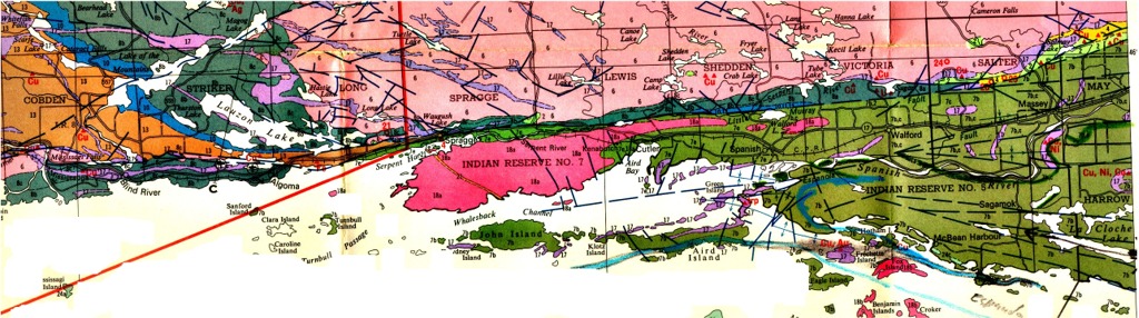
Landsat Image of the Coniston area, Sudbury
Keywords: Southern structural Province, Huronian, Penokean, Cutler, Killarney, Baldwin, Whitefish Falls, Elliot Lake, Aberdeen Township, Lake Huron, Coniston, Sudbury, Whitewater Series, Sudbury breccia, shatter cones, norite, granophyre, nickel , Nipissing Gabbro, North Shore diabase, Sudbury diabase, Grenville, anorthosite, metagabbro, eclogite, granulite, syenite, agmatite.
SUMMARY
NOTE: text in blue and underlined represents links to maps, photographs or special topics elaborating on some particular aspect/debate concerning the geologic history of the Southern Province of Ontario.
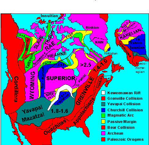
TheSudbury region encompasses parts of three structural provinces:
the Superior Province(> 2.5 Ga); the Southern Province (1.86 Ga); and the Grenville Province (1.0 Ga),
and is one of the foremost places in the world to examine plate tectonic mechanisms of crust formation over a significant portion of Precambrian time. In addition, the intersection of the three province boundaries at Sudbury marks the approximate location of the well known Sudbury meteorite impact site and its associated nickel-copper mineralization.
In terms of crustal evolution, the
greater Sudbury region provides an opportunity to examine:
1) Archean-type crustal development as evidenced by the rocks of the Abitibi belt of the Superior Province.
2)
the evolution of the Southern Province through its
various stages of rifting, volcanism and granite
intrusion, large scale obduction-related?
deformation, collisional polyphase deformation and
crustal melt formation, and the genesis of important deposits of
uranium and silver.
3) major mafic dike swarms injected at 2.45
Ga, 2.22 Ga, 1.75?,
1.4?, 1.24 Ga, and
575 Ma.
4) the deformational and igneous character of the 'Grenville Front' as the northern limit of the c. 1.0 Ga collisional Grenville and the c. 1.75 Ga Penokean orogens.
The Sudbury region also provides an unique opportunity to examine the consequences of large-scale mining on the environment, and the efforts that have been made to curb the negative effects of this activity.
The geological significance of the greater Sudbury region is at least on a par with that of the Gros Morne Park region of Western Newfoundland, declared a World Heritage Site by the United Nations because of its geology. (The Gros Morne site is located within the obduction-related foreland land basin of the Appalachian structural province, and is considered "apparently one of the best places in the world to see the legacy of plate tectonics".) In comparison, the Sudbury region should be declared a World Heritage geological super-site.
*******************************************************
Many aspects of the geology of the Southern Province remain controversial - compare the papers of Shaw et al., 1999 with that of Parmenter et al., 2002, or Riller v Redmond and Fueten, or Card v Dutch - and these will be treated below as 'Special Topics'.
The Archean
rocks exposed to the north of the Sudbury basin are dominantly gneissic
tonalitic and granodioritic rocks of the southern batholithic
belt of the
Abitibi sub-province.
Archean rocks are unconformably
overlain by rocks of the Huronian Supergroup
composed largely of terrigenous sediment derived from a northern Archean
source. The earliest deposits of the Huronian include a mafic
- felsic volcanic rift sequence known as the Thessalon Formation
in the western part of the Huronian, and as the Elsie Mountain/Stobie basalts
and Copper Cliff rhyolite sequence in the Sudbury region. The volcanism
is possibly related to the injection of the 2.45
Ga Matachewan diabases and related gabbro-anorthosite
intrusions (East Bull Arm and River Valley) found within the Superior Province north of
the Huronian and the Archean terrain of the northern Grenville Province
south-east of the Huronian, as well as to the localised tensile (rift)
deformation associated with the intrusion of the 2.477 Ga Creighton
and Murray granites of the Sudbury region. Basal conglomerates
of the overlying Matinenda Formation, composed of large rounded clasts
of vein quartz cemented by a matrix of pyrite,
are of economic importance because
they contain detrital uraninite. Other prominent
units in the Huronian include the
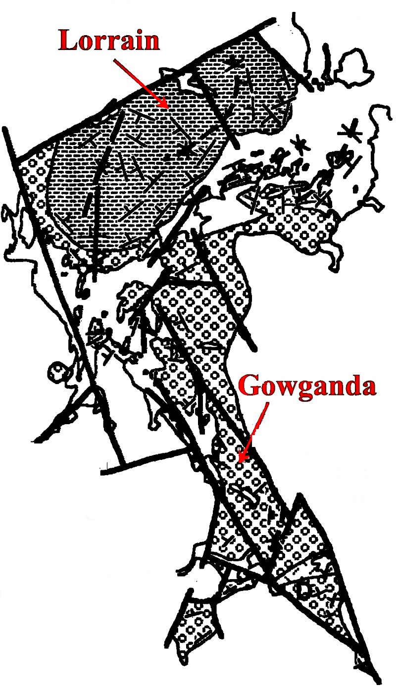
Gowganda Tillite,
one of the oldest known examples of a glacial deposit, and the overlying
white-weathering Lorrain orthoquartzite (but red coloured
where it is iron bearing, and green where it contains detrital chromite
derived from the weathering of Archean komatiites), representing the products of
intense tropical weathering of Archean
granitic crust. Sandstones with a relatively high proportion of haematitic
iron make their appearance in the uppermost Huronian, and possibly presage
the later global appearance of major Lower Proterozoic banded iron formations
(Lake
Superior region; Hammersley
of Australia).
The Huronian was
tightly
folded (Click here for photographs
concerning the Fold History) prior to or during the injection of gabbro
sheets of 'Nipissing
gabbro'at
2.2 Ga (Link
5, Link
1), and certainly prior to the injection of both NW and NE trending
diabase
dikes (see discussion
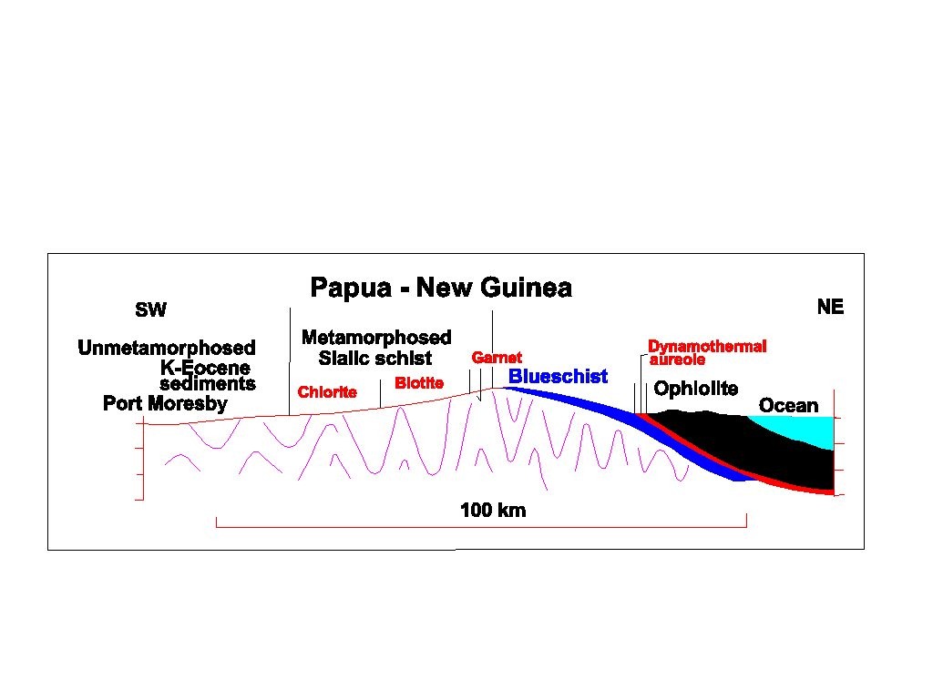
below). The mechanism of folding is not known, but, as in the case
of the passive margin sediments of Papua-New
Guinea, it may have been induced by the
obduction of oceanic crust
following the establishment of a Huronian passive margin. The Huronian
sediments must have been sufficiently indurated to support large scale
congruent folding and the development of an axial
cleavage. Given the arc-like chemical characteristics (low-Ti)
of the Nipissing gabbro, it is even conceivable that it marked a short-lived
'flip' in the subduction polarity shortly following the obduction event.
The structural architecture of the Huronian is similar to that of the rocks
of the Lower Proterozoic Hamersley
passive margin located on the southern margin of the Archean Pilbara
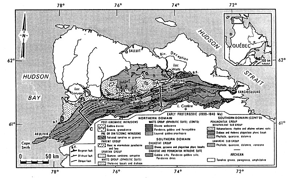
craton of Western Australia. In Canada an equivalent obduction event is
represented by the ophiolites of the Ungava
Peninsula.
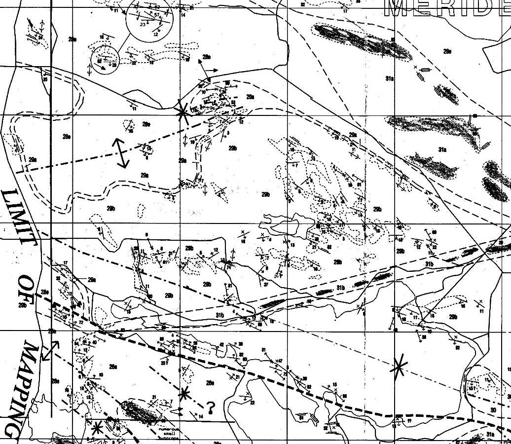
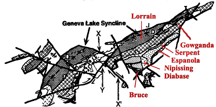
Link 1 - Schematic map of major structures in the Huronian of Espanola wedge - sudman.gif
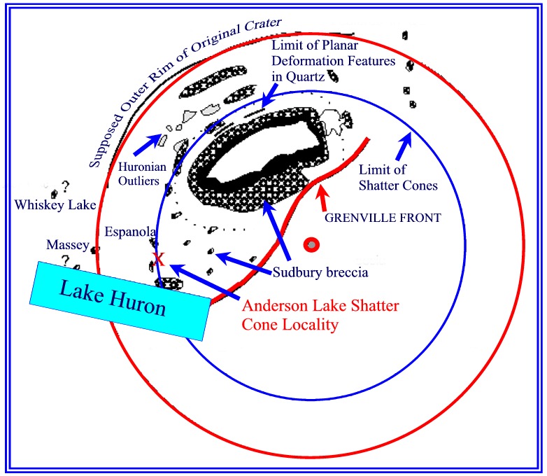
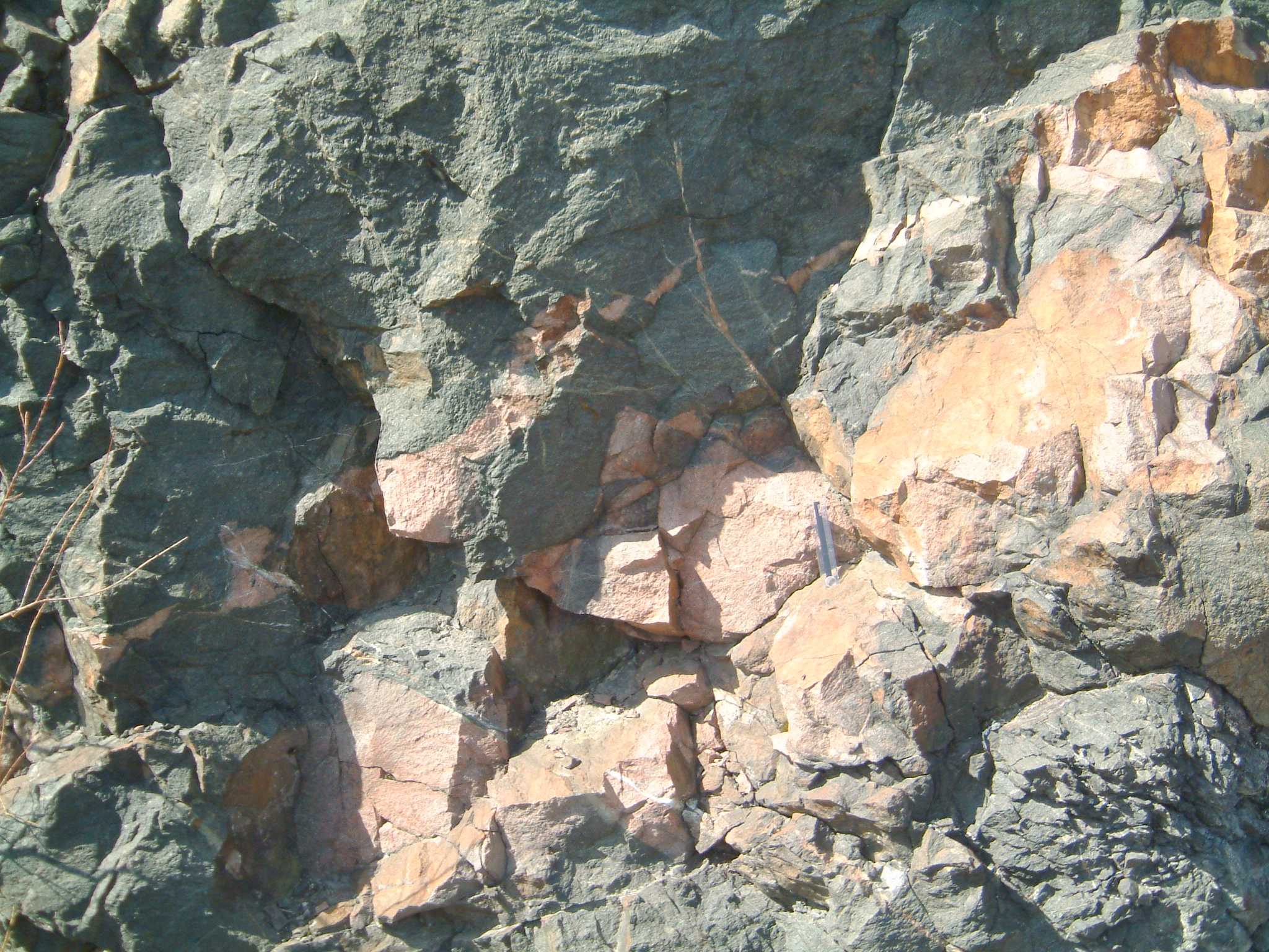
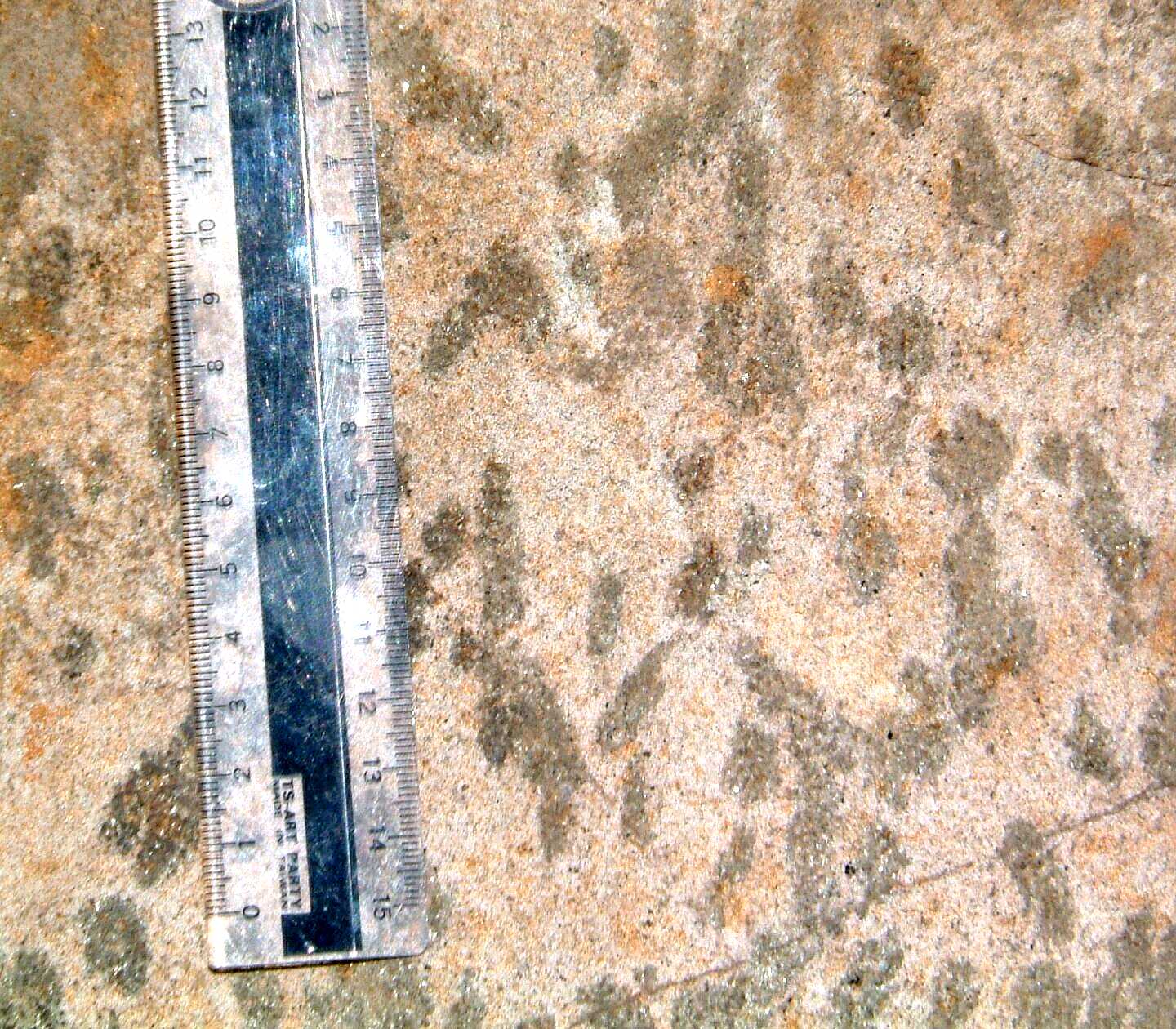
On the basis of the common presence of shatter cones in rocks of the Sudbury region (even as far west as Espanola) and the distribution of the enigmatic 'Sudbury breccia' and Onaping 'fall-back' rocks, it is thought that the Sudbury basin, even though presently preserved as an asymmetric syncline, represents the remains of a Paleoproterozic meteorite impact commonly referred to as the Sudbury event (Link 2). Huronian rocks throughout the Sudbury region, including gabbros of the Nipissing diabase association, were brecciated during the impact event, and fluidized breccia material (Acoustic fluidization; Sudbury breccia) is commonly found injected into Huronian rocks. The fall-back rocks are overlain by tubiditic mudstones and greywackes of the Whitewater Group, and the rocks of the impact crater were intruded by lopolithic sheets of mafic (norite, quartz-gabbro) to felsic (granophyre) material of the Sudbury Irruptive (1.85 Ga old), and associated 'Offset' dikes, supposedly generated by impact partial melting of Archean and Huronian rocks. The rocks of the Whitewater Group, the noritic rocks of the Irruptive, and the Huronian rocks beyond the Irruptive are cut by undated NE to ENE trending mafic dikes. Whether or not they are coeval with the Trap dikes intrusive into the Huronian outside the basin is not known. Within the norite the dikes exhibit chilled margins, suggesting that the Sudbury Irruptive was cool at the time of intrusion of the Trap dikes.
Link 2 - Some data on the Sudbury impact structure - where is the centre of impact? - grieve1.jpg
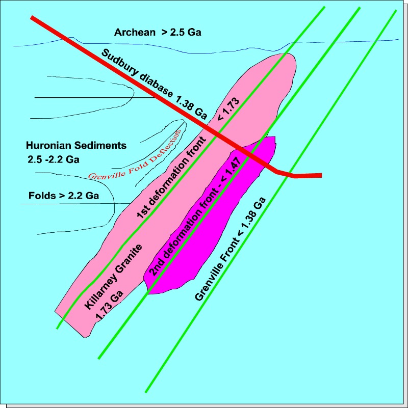
Deformation(S2,S3) subsequent to the Sudbury impact event may have been related to the closure and arc/continental margin collision documented within the Michigan/Wisconsin section of the c. 1.86 Ga Penokean fold belt, to events that post-dated the intrusion of the 1.75 Ga Killarney granites, and to non-penetrative events younger than the intrusion of the c. 1.4 Bell Lake granite.
The geological history
or the Sudbury area may therefore involve the following
events:
1) Deposition
of the Huronian sediments and volcanics (and
related igneous complexes).
2) Major
folding of the Huronian (F1 deformation
phase).
3) Injection
of Nipissing diabase.
4) The Sudbury impact
event.
5) Deposition
of the Whitewater sediments.
6) Penetrative pure shear
deformation
of the Huronian and Whitewater rocks (F2
deformation phase).
7) F3
folding of F2 cleavage/schistosity (change in orientation of
shatter cones on opposing fold limbs)
8) Intrusion
of the Sudbury Irruptive (1.85
Ga)
9) Intrusion
North Channel diabases (transects F3 folds and the Sudbury Irruptive)??
10) Syn-F4
(F3b) deformation intrusion of the Cutler
and Killarney granites (1.75
Ga)
11) Late post-deformation
metamorphism.
12) Intrusion
of the Bell Lake Granite (1.47
Ga).
13) Intrusion of Trap dikes??
14) Bell Lake Granite/South
Range Shear zone F5 deformation.
15) Injection
of the Sudbury Diabase dike swarm (1.238
Ga).
16) Grenville
deformation
and metamorphism (ca. 1.0 Ga) (F6
deformation phase)
17) Injection
of the Grenville dike swarm (575
Ma).
Selected references:
Bailey, J. , Lafrance, B. ,
McDonald, A. M., Fedorowich, J. S., Kamo, S. , Archibald, D. A., 2004.
Boerner, D.E., Milkreit, B., and Davidson, A., 2000. Geoscience impact: a synthesis of studies of the Sudbury Structure. Canadian Journal of Earth Sciences, v. 37, p. 477-501.
Davidson. A. 2001.The
Chief Lake complex revisited, and the problem of correlation across the Grenville Front south of Sudbury, Ontario. Precambrian Research.
v. 107, 5-29
Dutch, S.I., 1979, The
Creighton Pluton, Ontario: an unusual example of a forcefully emplaced
intrusion, Canadian Journal of Earth Sciences, v. 16, p. 333-349.
Card, K. discussion,
Dutch, S.I. reply, 1979, The Creighton Pluton. Canadian Journal of Earth
Sciences, v. 16, p. 2181.
Fueten, F. and Redmond,
D.J., 1997. Documentation of a 1450 Ma contractional orogeny presrved
between the 1850 Ma Sudbury impact structure and the 1 Ga Grenville orogenic
front, Ontario, BGSA, v. 109, 3, p. 268-279.
Krogh, T.E., Kamo,
S.L., and Bohor, B.F. 1996. Shock metamorphosed zircons with correlated
U-Pb discordance and melt rocks with concordant protolith ages indicate
an impact origin for the Sudbury structure. In : Earth processes: reading
the isotopic code. American Geophysical Union, Monograph 95, p.
343-352. (The Creighton granite, previously dated as 2333 and 2388,
is 2477+/-9.)
Parmenter, A.C., Lee, C.B., and Coniglio, M., 2002. "Sudbury Breccia" at Whitefish Falls, Ontario: evidence for an impact origin. Canadian Journal of Earth Sciences, v. 39, 6, p. 971-982.
Rousell, D.H. and Long, D.G.F., 1998. Are Outliers of the Huronian Supergroup
Preserved in Structures associated with the collapse of the Sudbury Impact
Crater . Jour. Geology, v. 106, p. 407-419.
Riller, U., and Schwerdtner,
W.M., 1997. Mid-crustal deformation at the southern flank of the Sudbury
basin, central Ontario, Canada, BGSA, v. 109, 7, p. 841-854.
Shaw, C.S.J., Young, G.M., and Fedo, C.M., 1999. Sudbury-type breccias in the Huronian Gowganda Formation near Whitefish Falls, Ontario: products of diabase intrusion into incompletely consolidated sediments? Canadian Journal of Earth Sciences, v. 36, p. 1435-1448.
SPECIAL TOPICS
Structures
of the Elliot Lake-Sault Ste Marie in the west (Jackson, S.L., 1994, Geology
of the Aberdeen Area; Ontario Geological Survey, Open File Report 5903,
69 p.) and north of the Sudbury basin in
the east (in preparation)
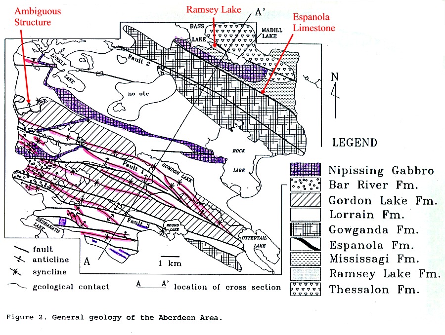
Aberdeen Township
Geology
at the western end of the Southern Province fold belt
The Murray Fault - OGS
Map 0281 Bruce Mines; OGS Map 0281 Cutler
General
Geology of the Aberdeen area
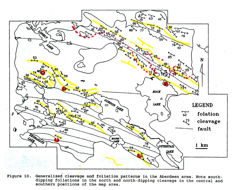
Foliation
patterns in the Aberdeen area
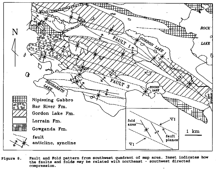
Fold
and fault patterns in the Aberdeen area
Complex
fold pattern in the Aberdeen area
The northern rim syncline of the Sudbury Dome
Rousell, D.H. and Long, D.G.F., 1998. Are Outliers of the Huronian Supergroup Preserved in Structures associated with the collapse of the Sudbury Impact Crater . Jour. Geology, v. 106, p. 407-419
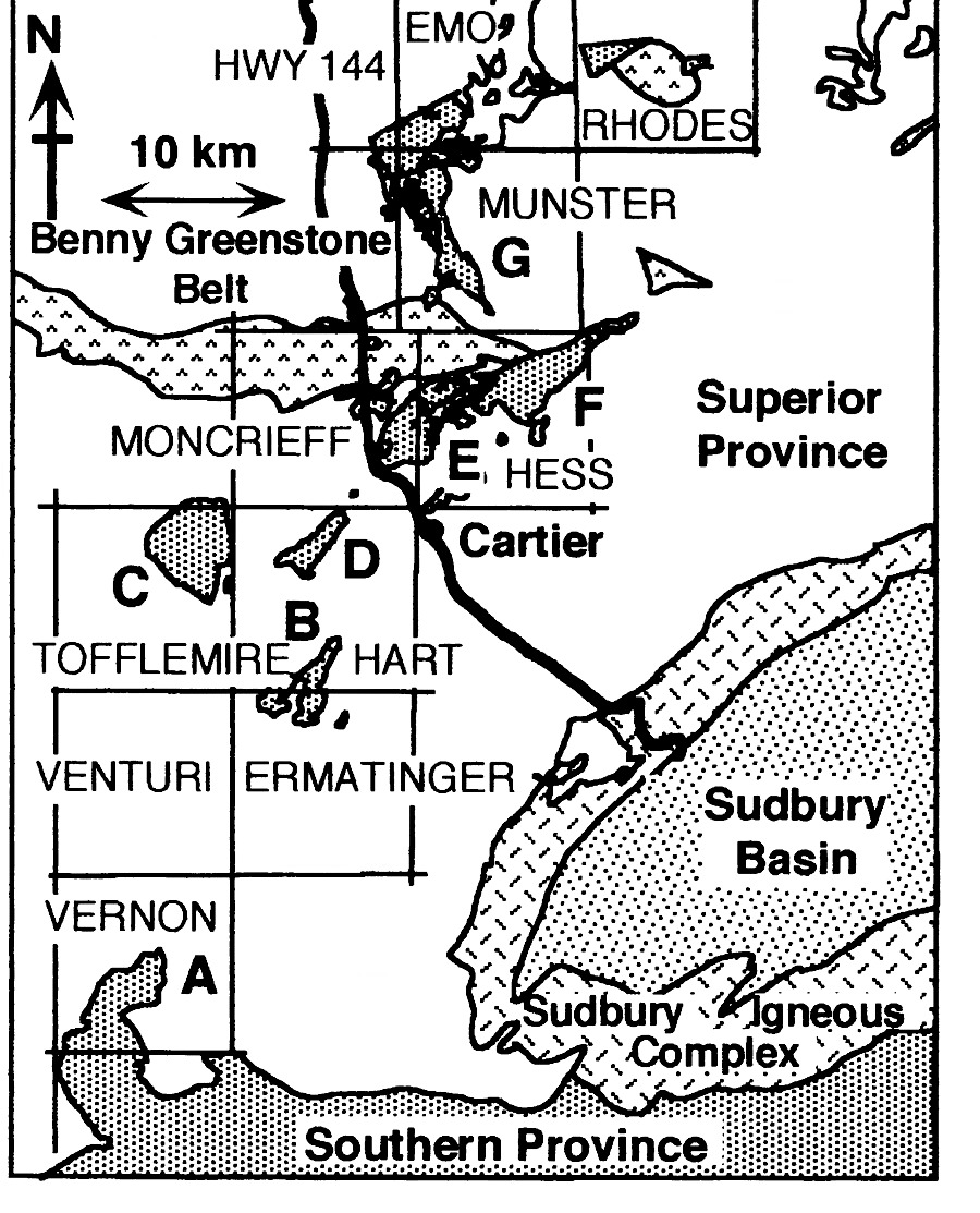
Regional Map
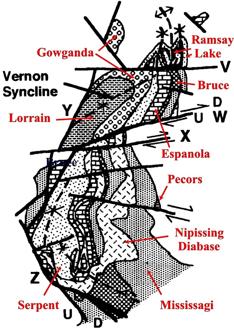
Vernon
A
South
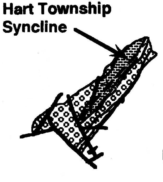
Hart B
Tofflemire
C
Hart
D
Geneva
Lake EF
Munster
G
The structure of the Coniston - Garson region (in preparation)
The
'Trap', North Shore, and other felsic dike swarms
The least well understood
aspect of the evolution of the Southern Province concerns the age and regional
correlation of the several phases of deformation that have affected the
Huronian and Whitewater groups, and their age relative to that of the 'Trap'
and North Channel diabases dike swarms, the Sudbury Irruptive, and the
1.75 Ga granites.
Following the early
main phase folding and the subsequent Sudbury Impact event, the Huronian
rocks of the Espanola wedge were affected by two
further phases of deformation. The earlier
of these phases involved penetrative
pure
shear and was developed best in the more highly metamorphosed rocks
located along the northern part of the Espanola wedge (Baldwin anticline
- Cutler belt). The second phase of deformation involved non-penetrative
simple
shear, is everywhere superimposed on the early
foliation as folds and a strain-slip foliation, and forms relatively large
scale folds within the northern Baldwin Anticline - Cutler belt.
Both phases can be recognised in more argillaceous rocks of the Mississagi
Formation and in the matrix material of Sudbury breccias present beyond
the southern limit of the Sudbury Irruptive.
The rocks of the Whitewater
series are also folded and foliated, and although there seems to be little
evidence that the Irruptive was involved in the deformation, the age relationship
of the folding to the Irruptive remains unclear. The Whitewater series
is cut by highly altered (chlorite) NE/ENE trending dikes of relatively
constant orientation, that do not seem to have participated in the folding.
'Trap dikes' (Link
3) that cut the norite member of the Sudbury Irruptive are however
deformed along with the Irruptive where the latter is involved in the relatively
local 'South Range Shear Zone'. The dikes are
converted
to amphibolite, with pleochroic amphibole mantling relict
cores of pyroxene. However, 'Trap dikes' cutting the Huronian
outside the Sudbury basin do not seem to be implicated in any of the phases
of deformation recorded in the Huronian, as seems also to be true of mafic
dikes with a 'Trap dike' trend in the Espanola region. I would not
therefore be unreasonable to conclude that intrusion of trap dikes and
the deformation of the South Range shear zone are relatively young. At
Alice Lake mafic dikes with a Trap dike trend are implicated in the mylonitization
event affecting the Grenville Front megacrystic granites, and the
South Range shear zone could therefore be younger than 1.4 Ga.
The Huronian is also
cut by mafic dikes of variable trend - in some areas, particularly in in
the southern part of the Espanola wedge, the trend is dominantly
northwest (Link
5, Link
6), whereas in the Sudbury region they dominantly trend ENE. At some
localities (Link
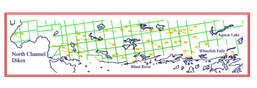
4) dikes trend NW, ENE and E-W, as also do the North Channel dikes
cutting the Huronian beween Elliot Lake and Sault Ste. Marie (Link
8). Whatever their orientation, the dikes all transect the early
major folds (Link
5, Link
6). The age relationship of the dikes to the Sudbury breccia and to
the various phases of deformation is however ambiguous. As is illustrated
in Link
7 one dike appears to transect breccia whereas the other diabase appears
to be brecciated. Furthermore, ENE trending dikes within Huronian
of the northern Espanola wedge clearly transect late stage open F3 folds
at the southwest end of Anderson Lake (Link
6), as do the ENE trending 'Trap' dikes in the Sudbury area, but NW
trending dikes in the Whitefish Falls area are implicated in deformation
that involves the formation of a prominent secondary foliation. Three
possibilities therefore arise:
1) there are two ages
of diabase dikes, one related to the Nipissing diabase intrusions, the
other related to the 'Trap' dike event;
2) all the dikes are
of the same age but the foliation in Huronian rocks of the southern Espanola
wedge is younger than the foliation forming event in the Baldwin-Cutler
belt of the northern Espanola wedge;
3) all the dikes are
of the same age but the deformation of the diabase at Whitefish Falls was
induced by the third-phase deformation present as non-penetrative shear
zones at this locality. In the region of the Cutler granite at the
western end of the northern Espanola wedge, the marked penetrative foliation
in 'Nipissing' garnet-amphibolites are deformed by crenulations and
folds related to the large scale folds cored by the Cutler granite.
The foliated gabbros
are cut by straight NW trending diabase dikes that also cross cut tight
folds whose relationship to the foliation has not however been established.
The diabase, although metamorphosed, exhibits shear strain only adjacent
to its contacts with the strongly foliated amphibolite. Straight trending
'Trap' dikes cutting highly foliated Creighton granite in the Sudbury region
also exhibits a shear foliation within cms of its contact with the granite,
but otherwise is not deformed. It is conceivable therefore that the Cutler
diabases post all the dominant phases of deformation, but are sheared by
non-penetrative late stage deformation equivalent in age to that which
produced the post-'Trap' dike deformation of the South Range Shear zone
of the Sudbury basin, and possibly the post-Bell Lake granite deformation
of the Grenville Front region (Link
3).
At Cutler NW-SE trending dikes are cut by pegmatites
associated with the Cutler granite.
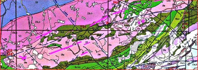
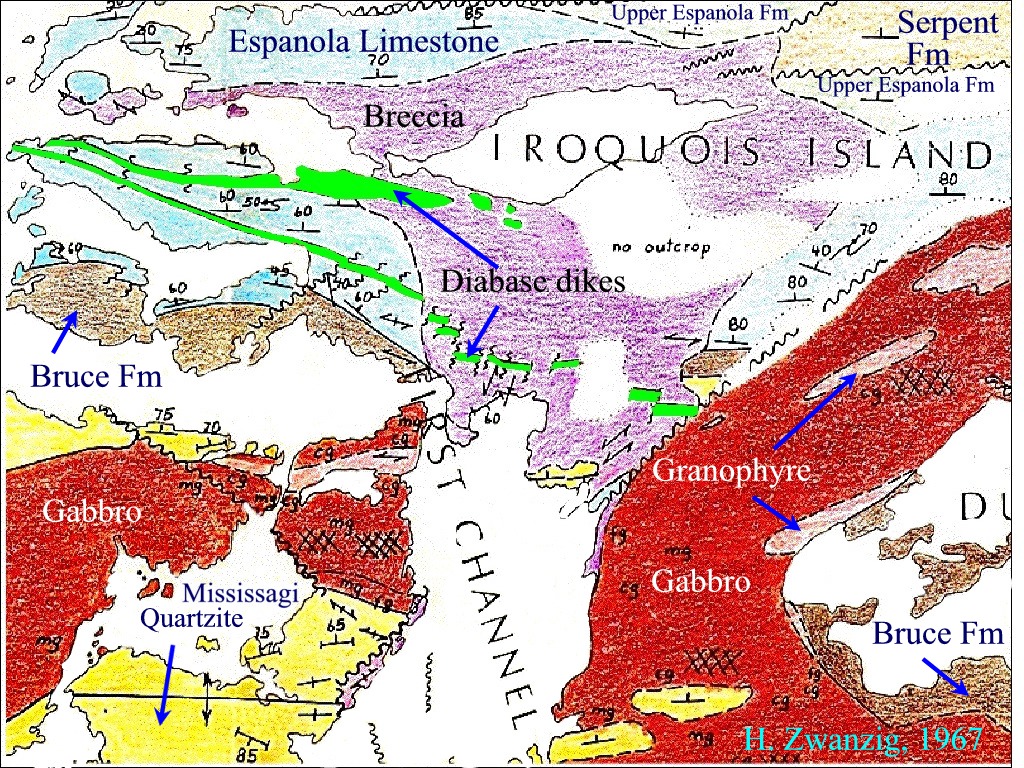
Link 3 - NE
trending 'Trap' dikes (unit 28, magenta) cutting the Creighton Granite
(pink), the Sudbury Norite (purple) and Huronian rocks (green) near
Lively - lively.jpg (Map 2360)
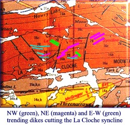
Link 4 - Variable
trending dikes (green, magenta, and cyan) cutting Huronian rocks folded
by the La Cloche syncline, south of Howry Lake - howrylake.jpg (Map
2360)
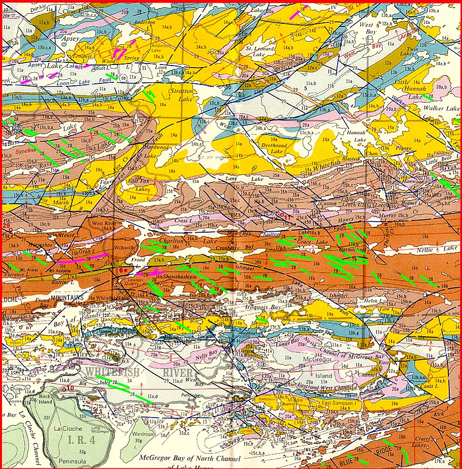
Link 5 - Map
showing the location of NW (green) and E-W/NE trend (magenta) dikes
transecting tightly folded Huronian rocks between Lake Huron and Espanola,
Sudbury-Manitoulin OGS Map 2360, K.D.Card, 1976 - dikes1.jpg
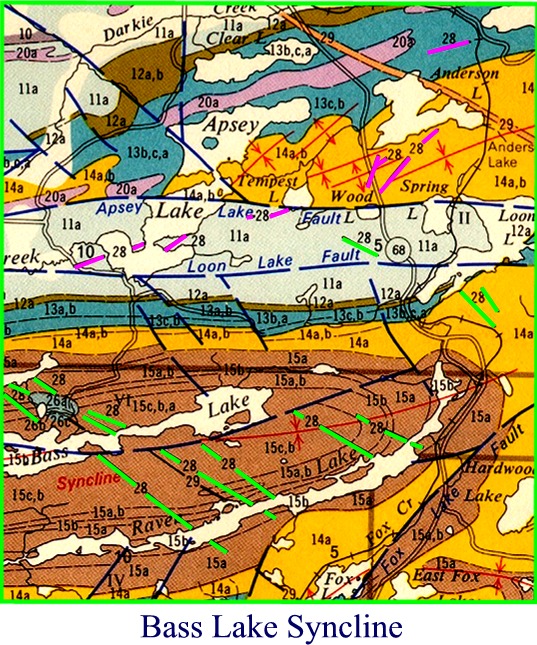
Link 6 - NW
trending dikes (green) cutting Gowganda rocks of the the Bass Lake syncline,
and NE trending dikes (magenta) cutting 3rd phase folds north of the Apsey
lake - Loon Lake fault system - basslake.jpg
(Map 2360)
Link 7 - Dike
relationships in the McGregor Bay region of the southern Espanola wedge
- zwanzig2.jpg
Link 8 - North
Channel dikes - nchanneldikes.jpg
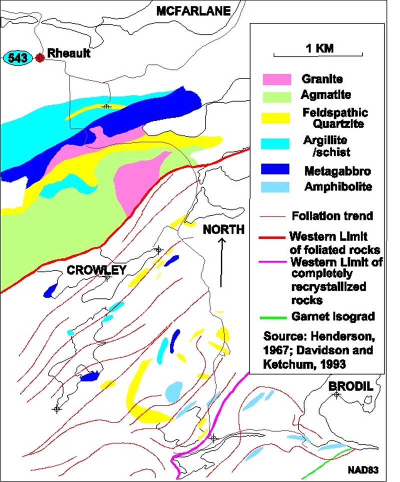
In
the Coniston-Garson area of the Sudbury region, Mississagi Quartzite is
cut be a suite of vertical but variably trending garnet-
and amphibole needle-bearing felsic dikes. The dikes transect foliated
Sudbury breccia and are quite undeformed. The rocks of this area
are also injected by rare veins of pegmatite. Rare sheets of granitic
rock also intrude Mississagi quartzite south of the Murray Fault on
the Sudbury road to Rheault (Paris St), and in Rheault itself heterogeneously
deformed Nipissing Gabbro within the Long Lake Fault is irregularly injected
by pink granite.
Deformation
History of the Huronian south of the Murray Fault in the Sudbury region
(OGS Map 0218)
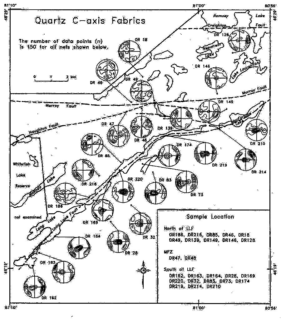
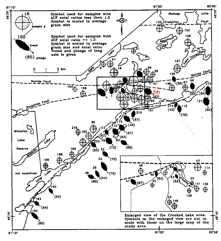
Fueten and Redmond (1997)
have established on the basis of an analysis of quartz
c-axis orientations and grain shapes in Mississagi quartzites, and
of clast orientations in Sudbury breccia,
that the area of Huronian rocks between Sudbury and
the 'Grenville Front' can be subdivided into three fault bounded structural
panels.
Quartz grains in the
northern panel north of the Murray fault are very little strained, and
clasts in Sudbury breccia show no preferred orientation.
In the central panel
between the Murray and Long Lake faults, strain as indicated by
grain shape
is
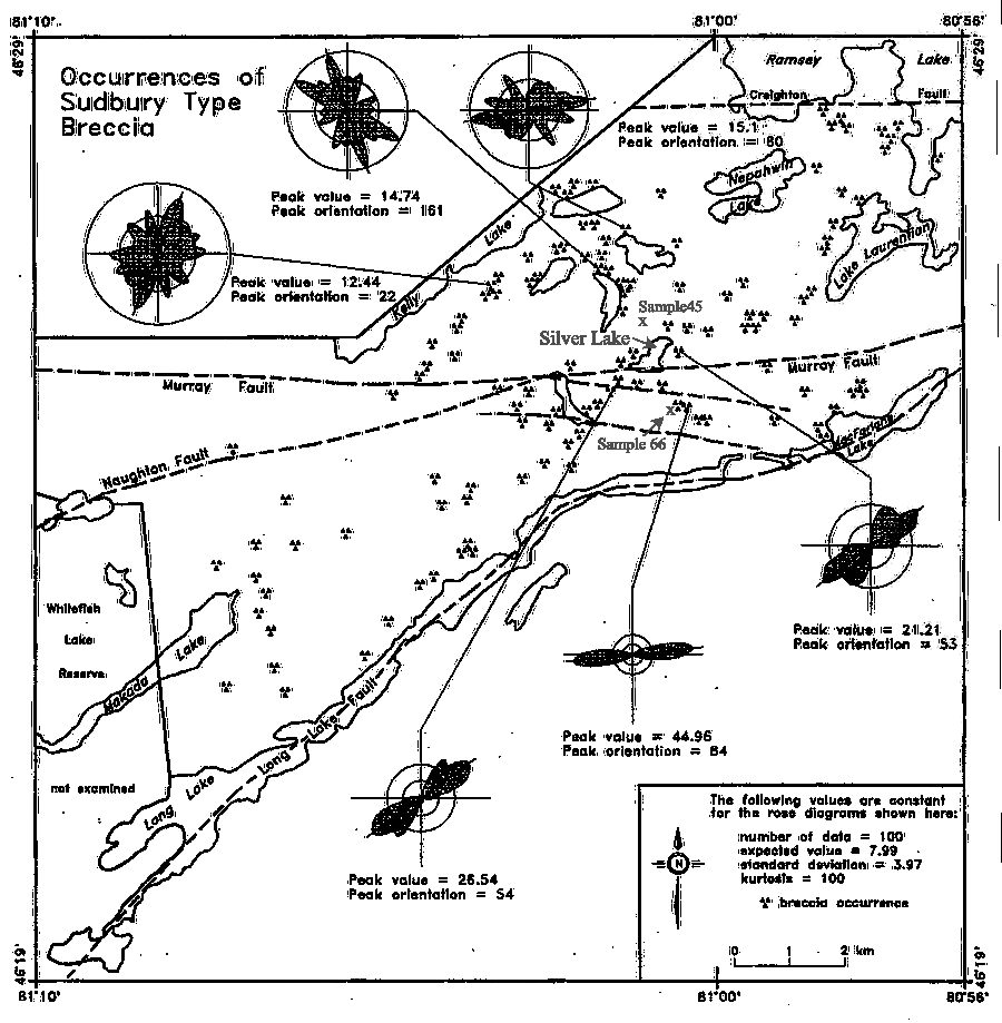
highly variable. At three localities in
the vicinity of Silver Lake, clast orientations in Sudbury breccia on hoth sides of
the Murray Fault show a marked preferred orientation, but only in one case,
southeast of Silver Lake, does the clast preferred orientation seem to
correlate with a preferred quartz grain shape-fabric in quartzites (sample
66). A high strain zone seems to be located west of Crooked
Lake (south-west of Silver Lake) represented by samples 47, 48, 49, and
63, but even here they seem to delineate localized zones of non-penetrative
deformation. Given that some high strain breccia zones and the locations
of samples of quartzite with strong preferred shape orientations are indicated
to occur north of the Murray Fault, it would seem that the latter structure
only approximately marks the onset of occurrence of non-pentrative
strain in Mississagi quartzites. The quartz c-axis patterns in the
middle panel between the Murray and Long Lake faults are also very variable,
again implying non-penetrative anastomosing
deformation in this panel.
South of the Long
Lake fault however, quart c-axis orientations
exhibit strong point maxima and deformation in the southern panel
in the samples collected by Richmond and Fueten is strong and penetrative,
and the Long Lake fault in the Reault area is likely a much more important
structure than the Murray fault. Nevertheless staurolite-bearing
schists of the Percors Formation that outcrop south of the Long Lake fault
exhibit varying degrees of secondary strain ranging from porphyroblastic
schist to highly flattened flagstones
in which coarse staurolites have been replaced by thin aggregates of chlorite.
On the basis that Sudbury
breccia clasts north of the Murray fault zone show no preferred alignment,
and folds can be traced north of the Murray fault to the west of the study
area, Fueten and Redmond (1997) suggest that the bulk of the deformation
north of the Murray fault zone in the study area pre-dated the 1850 Ma
impact event, and that while significant deformation affected the area
following the Penokean orogeny, they were unable to correlate any
deformational features with the emplacement of the 1750 Ma phases of the
Chief Lake Complex. They further suggest that the ca. 1750 Ma magmatic
event was passive, representing anorogenic magmatism, and that the deformation
fabric in rocks south of the Long Fault represents an important post-1.46
Ma phase of deformation that may have penetrated as far north as the southern
margin of the Sudbury basin.
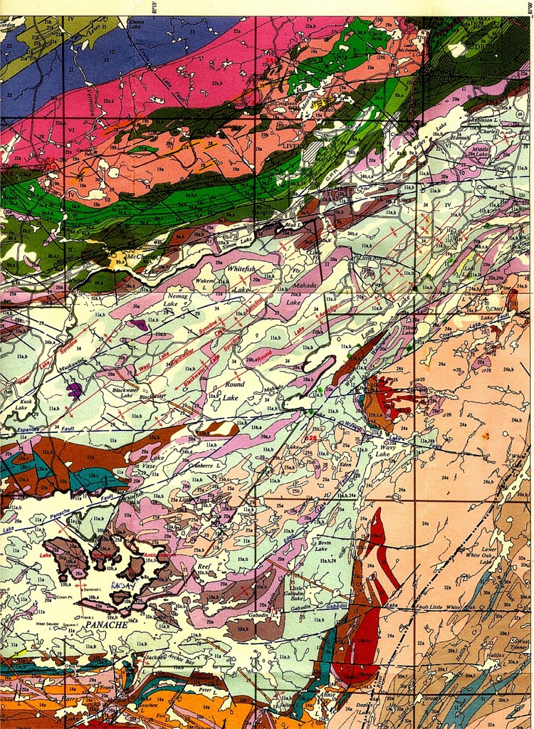
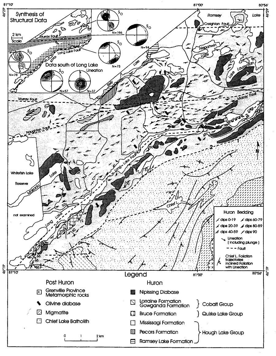
The Long Lake fault as defined by Fueten and Redmond may be the continuation of the Lake Panache - Apsey Lake fault which separates the deformed Huronian into two distinct structural panels. To the south of the fault Huronian rocks occur in the form of large scale, tight vertical folds ( La Cloche and Bass Lake synclines; McGregor Bay anticline), whereas to the north of the fault folds in the Huronian are relatively open smaller scale structures. Argillites involved in the tight folds of the southern structural panel do not exhibit a coeval axial planar mica fabric.
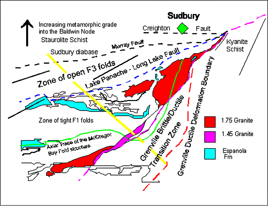
Figure 1. - Structural elements of the Southern and Grenville Province southwest of Sudbury
The folds (D1) of the
southern panel are transected by Nipissing Gabbro and Sudbury Breccia,
in that order, and are therefore pre-2.2 Ga, pre-impact, and pre-Penokean
- if this term is restricted to deformation associated with the 1.86 Penokean
collision event of Michigan-Wisconsin. The tectonic environment of formation
of the early large scale folds is not known, but an analogy could be drawn
with the enigmatic first-phase fold deformation of the Moine-Dalradian
clastic wedge of the Scottish Caledonides, and the tight vertical folding
induced in the Port Moresby continental margin sediments by obduction of
the Papuan-New Guinea ophiolite. The most prominent planar fabric
in Huronian rocks of the southern panel is a 'strain-slip'
cleavage (D2) of variable intensity which cuts across the earlier
folds, Nipissing diabase and Sudbury breccia. It microfolds an earlier
mica cleavage which is congruent with the first generation major folds,
and also acted as the locus of development of a third-phase fold and crenulation
cleavage fabric (D3). Aluminous quartzites of the Lorrain Formation contain
pre-deformation pyrophylite and kyanite, and post-deformation andalusite;
and cleaved pelitic rocks contain randomly oriented porphyroblasts
of late-growth biotite. Microscopic garnet occurs rarely in some
cleaved argillites of the Gowganda formation at Whitefish Falls.
On the other hand,
the prominent open folds north of the Apsey Lake fault (cf. Card, 1978;
Map 2360) fold a fine grained slaty cleavage (D2') which cuts
Sudbury breccia bodies in this zone. The strain and metamorphism associated
with the cleavage is low, and shatter cones can be recognized in quartzose
rocks at least as far west as Anderson Lake, south of Espanola. It would
seem likely that the quartzose rocks of this panel never were deformed
sufficiently to develop a strong Penokean fabric, and it would seem equally
unlikely therefore that the quartz c-axis fabrics described by Fueten and
Redmond in rocks north of the Long Lake fault are reset ‘Penokean-aged’
fabrics. Nevertheless, the presence of an axial planar cleavage in
argillites of this zone attests to the existence of a post-Sudbury breccia
(post -impact) phase of deformation. A similar cleavage fabric is also
found in the argillites, Sudbury breccias, and even pelitic material filling
shatter cone fractures, immediately south of the Sudbury Basin at Copper
Cliff. Again however, the associated quartzites exhibit little in
the way of ductile deformation. If the slaty cleavages in both the southern
and northern panels are coeval (D2=D2'), it would not be unreasonable to
correlate the prominent folds (D3') of the northern panel with the strain
slip fabric (D3) of the already vertically folded southern panel.
In contrast to the rocks
of the Anderson Lake low ‘grade’ zone, the Huronian McKim Formation north
of the Espanola fault, exhibits a well developed mica cleavage (D2') which
cuts across Sudbury Breccia bodies and also post-dates growth of chloritoid
and staurolite. An earlier poorly developed bedding plane cleavage (D1'),
best delineated by oriented laths of ilmenite is however sometimes present
in argillaceous units of the McKim, suggesting that these rocks may
have suffered some degree of deformation prior to the Sudbury event.
In Baldwin Township north of Espanola, the more prominent cleavage (D2')
is coarse grained and commonly refolded by a penetrative crenulation fabric
(D3'), which is further overprinted by a late phase of crystallization
involving garnet growth and the generation of an annealed quartz fabric.
The effect of the Murray fault in disrupting the architecture of
the Huronian within the Baldwin structural panel is minimal, and the speculations
of Zolnai et al (1984) proposing 15 km of structural relief along the Murray
fault are therefore debateable. The domal metamorphic zonation is perhaps
controlled by some process of thermal convection related to granite
intrusion rather than by the upthrusting of deeply buried rocks.
Furthermore, at the western end of the Baldwin metamorphic belt the ca
1.75 Ma Cutler granite is located within a late D3' fold which folds a
prominent post-Sudbury Breccia foliation (D2') that is either syn- or pre-granite
intrusion. Also, deformed Huronian rocks of the Espanola Wedge are transected
by the 1.475 Ga Croker Island complex, described by Card et al. (1972)
as a an epizonal, post-tectonic intrusion exhibiting a narrow hornfels
contact zone. Consequently, it seems unlikely that all the deformation
fabrics, including the D3/ D3' folds, are strictly Penokean (1860 Ma) in
age.
The
deformation history of the Sudbury Basin
Within the Sudbury basin,
neither the fold deformation of the Whitewater Group nor the strain fabric
of the South Range shear zone are likely to be coeval with the pre-Sudbury
Breccia deformation outside the basin. However, it is uncertain whether
the folding of the Whitewater Group is equivalent to the prominent post-Sudbury
Breccia foliation (D2/D2') common to all structural domains in the Espanola
Wedge, or, alternatively, to the later D3/D3' folds. The deformation
represented by the South Range shear event was separated from the D3/D3'
fold event outside the Sudbury Basin by the intrusion of the undated ENE
trending 'trap' dyke suite, and given that the 'Trap' dykes were affected
by the late stage metamorphism (pleochroic amphibole mantling relict cores
of pyroxene and amphibole) that produced the 'Cutler-Baldwin'-type annealed
fabrics in the staurolite-bearing McKim argillites outside the Sudbury
Basin, it remains possible that the South Range shear deformation was a
late non-penetrative c. 1.75 Ga event. Furthermore, south of the
Murray Fault about 1.5 km south of the SE corner of Silver Lake on the
road to Rheault, sheared Huronian quartzites are cut by undeformed
dikes of undated microgranite. On the other hand, ENE trending mafic dikes
within mylonitized megacrystic granites at the Grenville Front near
Alice Lake have suffered the same deformation as the granites, and if these
granites belong to the 1.46 Bell Lake intrusive suite rather than the 1.75
Killarney suite then the 'Trap' dikes could be younger than 1.46 Ga, as
would also be therefore the age of the South Range shear. In this case
the growth of amphibole in 'Trap' dikes within the South Range shear would
be of only local significance.
The
1.75 Ga Cutler and Killarney Granites
At c. 1.75 Ga, granitoid bodies were intruded
in both the Cutler and Grenville
Front areas, and the 'Killarney granites'
of
the Grenville Front region were subsequently injected by the younger
c.
1.4 Ga Bell Lake granite and associated
pegmatite bodies. The Grenville Front granitoids are flanked along their
southeast margin by folded gneisses which locally include belts of
kyanite-garnet-biotite
schist - perhaps representing
metamorphosed Huronian age aluminous metasediment
intercalated within Archean gneisses. Some quartzite units within
this belt are almost certainly Huronian equivalents because they
contain detrital zircons of Archean age and zircon needles, evidently
of metamorphic origin, with an age of 1.7
Ga. Metagabbro bodies injected into these rocks may belong to the
Nipissing diabase suite. The gneisses also contain deformed anorthosite-gabbro
bodies of early Proterozoic age, and a gabbro-
granophyre body (Wanapitei complex) dated at 1.75
Ga. All these rocks units were injected by 1.24
Ga
olivine-bearing diabases (often containing
large xenocrysts of plagioclase) of the Sudbury swarm. Within the
Southern Province the diabases are straight and only locally faulted,
but when traced into the Grenville Province, they become irregular in
form, are cut by non-penetrative mylonite zones, and contain metamorphic
spinel and garnet. Further into the
Grenville
Province the diabases become penetratively deformed and form isolated
boudins of pyroxene-garnet or garnet-amphibole rock. Within shear
pods the igneous texture of the diabases are easily recognisable in spite
of the replacement of plagioclase by garnet. The penetrative deformation
represents the Grenville orogeny.
Cutler granite
Link 9 -
Deformation
events in the vicinity of the Grenville Front -grenv1.jpg
Link 10 -
Geology
of the 'Grenville Front' near Rheault-Broder Lake, south of Sudbury - broder83.jpg
The
Grenville Front Problem south of Sudbury - history of data acquisition
Quirke and Collins (1930)
concluded that "the Huronian formation, traceable eastward for 225 km from
Sault Ste Marie, does not terminate at the Grenville Front but exists south
of the Front in a highly recrystallized and metamorphosed state.", a conclusion
also reached by Phemister (1961). Brooks (1967) mapped the 'Grenville Front'
in the vicinity of Bell Lake and concluded that 'Grenville Front' tectonism
(development of slip-planes) was synchronous with the generation of the
'Killarnean' granites, that there was slightly later granite intrusive
activity accompanied by the contact metamorphic growth of andalusite and
cordierite, and that the younger granites (Bell Lake granite) were subject
to non-penetrative cataclastic deformation that produced zones of cataclastic
gneiss. The Bell Lake granite was also indicated to contain a primary foliation
marked by the parallelism of microcline phenocrysts (Brooks, 1976). He
also showed that at Johnny Lake a straight trending olivine-diabase dyke
(Sudbury diabase) cutting the Bell Lake granite was cataclastically deformed
along with the granite.
Krogh and Davis
(1969, p. 230) obtained a 1.75 Ga Rb-Sr four point isochron age for rocks
collected from the Chief Lake complex of granite rocks in the vicinity
of Broder Lake (Henderson, 1967, p. 279), and a Rb-Sr age of 1.6 Ga for
muscovite from a northeast-trending granite dyke that intrudes Huronian
rocks along the northwest margin of the Chief Lake complex. They also reported
an age of 1.45 Ga for muscovite from a strongly foliated granite. Krogh
and Davis concluded that the Chief Lake granite complex was "intruded into
the 'Grenville Front' 1700 m.y. ago and that it underwent plastic... (southeast
margin)... and brittle deformation... (northwest margin)... then or at
some time earlier than 1450 m.y. ago." (Krogh and Davis (1970,
p. 310) later determined an age of 1.63 Ga for muscovite in the undeformed
part of a variably Grenville deformed pegmatite located southeast of the
'Grenville Front' in the vicinity of Highway 69, and an age of 988+/-2
Ma for monazite in a cataclastically deformed pegmatite at the same locality
(Krogh 1994, p. 971).)
Krogh and Davis
(1970) recognized the existence of two ages of granite along the 'Grenville
Front', and also reported that pegmatites containing coarse muscovites
with ages of 1.44-1.47 Ga cut the foliation in coarse-grained impure quartzites
south of the Bell Lake granite, and near Carlyle Lake (pers. comm . to
Brooks, 1976) contain inclusions of mylonitized Killarney granite. (The
Killarney granite was subsequently dated by Davidson and Van Breemen (1994)
as having a zircon age of 1.74 Ga, and the Bell Lake granite a zicon age
of 1.47 Ga (Van Breemen and Davidson, 1988).)
The first serious mapping
of the southwestern part of the 'Grenville Front' region by Frarey and
Cannon (1969) separated the Killarney granite (unit 7b) from the Bell Lake
granite (unit 7a), showed the existence of a foliation in the eastern margin
of the Killarney granite (unit 9d), and demonstrated that dykes of the
Sudbury dyke swarm not only transected the granites but extended well to
the southeast of the 'Grenville Front'. Subsequently, the Grenville Front
was located coincident with a major myolite zone along the eastern margin
of the granite belt. (The location of the mylonite zone at the Killarney
end of the belt was susequently relocated further east by Davidson (1986).)
Study of the section
of 'Grenville Front' southeast of Sudbury led Brocoum and Dalziel (1974)
to propose that the supposed Grenville deformation at this locality was
Penokean and entirely older than the dykes of the Sudbury swarm, and that
"the major ductile deformation of the rocks of the Sudbury Basin, the eastern
part of the Southern Province, and the northwesternmost Grenville Province
was coeval". They allowed however that post olivine-diabase cataclastic
(brittle) deformation was also present along the length of the 'Grenville
Front' (Brocoum and Dalziel, reply to Brooks, 1976).
Lumbers' map of the Burwash
region (1975) showed the 'Grenville Front', which he termed the Grenville
Front Boundary Fault, located at the western limit of penetrative
deformation within the granitic rocks of the Front.
A paleomagnetic and chemical
compositional study of Sudbury diabases in the Southern and adjacent Grenville
provinces by Merz (1976) showed that Sudbury diabases in or near the Grenville
Province had had their TRM reset as a result of Grenville metamorphism, and was
the first to recognise that the metadiabase segments cutting gneisses
within the 'Grenville' were correlative with Sudbury diabase dykes in the
Southern Province.
Merz also showed that some of the dikes, currently referred to the Grenville dyke suite, were Paleozoic in age. Sampling of Sudbury diabase
dykes in the Tyson Lake region in 1972 (Church, 1992) showed that the Grenville
metamorphism was recognisable in the growth of microscopic garnets in the
chilled margins of dykes, which otherwise appeared unmetamorphosed and
undeformed other than where they were cut by non-penetrative shear zones.
Davidson (1986) confirmed
the contention of Krogh and Davis that the Killarney granite had undergone
deformation before emplacement of pegmatite and Sudbury diabase, as well
as Card's (1976) discovery of volcanic rocks in large xenoliths near the
margin of the Killarney granite. He also showed that the linear deformation
fabric within the eastern margin of the Killarney granite had a different
geometry to that in the bordering Grenville gneisses.
Davidson and Bethune
(1988) concurred with Merz's contention that the metadiabase segments
cutting 'Grenville' gneisses were correlative with Sudbury diabase dykes
in the Southern Province. They documented the presence of metamorphic orthopyroxene
in dykes at Broker Lake, and suggested that this indicated considerable
uplift across the northeast-striking faults and mylonite zones associated
with the 'Grenville Front', but little lateral post-dyke displacement.
They further suggested that the 'Grenville Front' in the Tyson Lake area
be relocated slightly to the southeast to mark both a change in a change
in the geometry of the dikes and of the style of deformation from brittle
to ductile in the Sudbury diabase dykes of this region, even although the
ductile deformation zones were non penetrative. In particular, Davidson
and Bethune suggested that the intrusion of the Sudbury dykes was syntectonic
with respect to Grenville style deformation, which therefore must have
begun before c. 1.24 Ga in the Tyson-Killarney region.
This theme was repeated
in Green et al. (1988) who proposed that the GLIMPCE seismic fabric of
Grenville rocks beneath Georgian Bay about 70 km south of the exposed rocks
on the north shore of this region was produced by : 1) depression to lower
crustal depths of rocks along the northern margin of the Grenville Province
as a result of the progressive stacking of microterranes against the Superior
craton, possibly coeval with island-arc magmatism at 1.25-1.3 in the Grenville
Central Metasedimentary Belt, and 2) thrusting, after intrusion of the
Sudbury diabase dykes, of the rocks buried deeply by the earlier stacking
episode back up to shallow depths. Accordingly, the GLIMPCE seismic
fabric of the Grenville Front Tectonic Zone thus largely reflects the formation
of highly reflective shear and mylonite zones during late Grenville thrusting
under ductile conditions, rather then any pre-Sudbury diabase front-parallel
deformation fabric.
Geochronological studies
of Haggart et al. (1993) showed that between the Grenville Front mylonite
zone east of Killarney and Beaverstone Bay, titanites were progressively
reset to Grenville ages, with complet resetting being achieved in the vicinity
of the eastern shore of Beaverstone Bay. Krogh (1994)
also showed that monazite in an undeformed in situ pegmatite (Tyson Lake
locality 1e) containing inclusions of lineated Huronian metasediment and
undeformed pegmatite has a concordant age of 1.45 Ga, as does titanite
(locality 1b) in an undeformed pegmatite cutting gneisses southwest of
Tyson Lake. Grain tips from zircons in pegmatite at Tyson Lake and Beaverstone
Bay also have near concordant ages of 1.45 Ga, whereas titanite from undeformed
pegmatite at Beaverstone Bay lies on a 1.45 Ga - 977 Ma chord, 78% discordant
towards a time of Grenville resetting. The resetting approximates
changes in the metamorphic mineralogy of the Sudbury diabases as they are
traced into the Grenville, but with the first appearance of garnet in the
chilled margins of the diabases at Tyson Lake providing a more sensitive
record of the Grenville thermal event.
More recently Bethune
(1998) has however proposed that the erratic course of Sudbury diabase
dikes east of Tyson Lake is the result of 1B - 1C type buckle folding,
although the proposal is qualified by the statement that some prominent
90 degree bends are not easily reconciled with buckle folding. Furthermore,
the supposedly buckled dyke east of Aqua Lake transects the axial plane
traces of tight folds outlined by paragneiss units in this area, and the
gneisses here form part of the zone within which undeformed pegmatites
have pre-Grenville 1.47 Ga ages. Panels of rock transected by linear east-west
trending segments of Sudbury diabase and bordered by zones of ductile mylonite
also continue to appear well to the east of this zone, and Grenville deformation
may be fully penetrative in character only east of the Beeftea Lake Sudbury
Diabase location.
The distribution of deformed
and metamorphosed Sudbury diabase (unit 48) on the Burwash Map sheet of
Lumbers (1975), and the presence of penetrative ductile folding in
'Grenville' rocks on the west flank of the Bigwood synform as far west
as a boundary line drawn approximately between Oak Lake, Beeftea
Lake and Chaughis Bay (?) on the north coast of Georgian Bay, might indicate
that the penetrative fabric of the rocks to the west of this line still
largely reflects pre-Grenville deformation events, the earliest of which
likely even pre-dates intrusion of the c. 1.75 Ga Killarney granite. An
old deformation fabric is possible preserved in a shear pod of 2.45 Ga
anorthosite in Dryden Township, and in agmatite associated with the
1.75 Ga (Prevec, 1994) mafic rocks of the Wanapitei shear pod, both of
which are cut by undeformed, garnet-bearing Sudbury diabase. On the
other hand, agmatites, gabbros and dike units of the Red Deer Lake shear
pod show no signs of pre-Sudbury diabase internal penetrative deformation.
Consequently, while non-penetrative deformation in this sector may well
include the formation of Grenville age (post-Sudbury diabase) mylonite
zones and the local development of brittle foliation fabrics in the 1.47
Ga Raft Lake (Davidson and Ketchum, 1993 and perhaps Bell Lake intrusions,
there is little evidence to support the possibility that the deformation
fabric in the gneisses west of the Oak Lake-Beeftea Lake line are of this
age. In this respect it might also be noted that quartzite at Beaverstone
Bay (Krogh, 1989, p. 63) contains not only euhedral grains of Archean zircon
but also 1.75 Ga zircons in the form of long needle-like crystals.
While it is clear therefore
that the boundary between Huronian metasediments and highly deformed gneisses
in the region between Wanapitei and Brodil Lake marks the sharp northern
limit of the Grenville Province, south of Brodil Lake the northern boundary
of Grenville penetrative deformation is more likely to be marked by a necessarily
'fluid' line between White Oak Lake and Chaughis Bay, and some distance
to the east of the ductile mylonite zone used by the GLIMPCE project as
the eastern boundary of the Grenville Front Tectonic Zone. Since the penetrative
fabric west of this line is likely to be pre-1.47 in age, the gneisses
within this belt should be ascribed to the Southern structural province.
It is possible therefore
that K-feldspar megacrystic rocks of the Killarney-Tyson lake sector of
the "Grenville Front" exhibit both a primary foliation (Brooks, 1967)
and a younger cataclastic mylonitisation, and while the latter may locally
affect adjacent rocks of the Southern Province, it is not clear yet how
this fabric is distributed either within the granites to the south or within
the Huronian rocks along strike to the southeast, or the extent to which
the fabric may be related to the pre-1.47 Ga foliation of the eastern deformed
zone of the Killarney granite.
The Grenville Province (see also http://instruct.uwo.ca/earth-sci/300b-001/grenv.htm)
(Maps yet to be scanned)
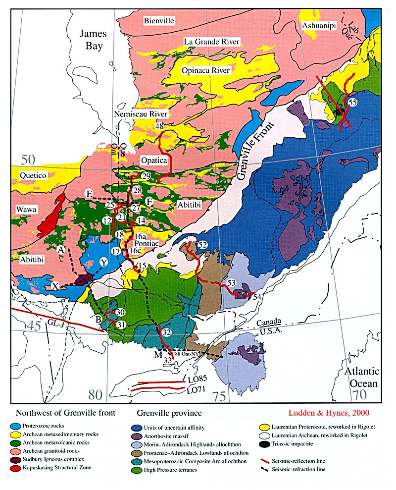
It has been argued on the basis of lead isotope data (DeWolf and Mezger, 1994) that in Ontario Archean crust, or Lower Proterozoic rock derived from the Archean, underlies the northern Grenville Province at least as far to the south as Parry Sound. The overlying Grevillian tectonites form a southeasterly dipping thrust stack composed of rocks raging in age from Archean to Late Mesoproterozoic (995 Ma).
Sections
across the Grenville Province, Ludden & Hynes, 2000 - grenxsect.jpg
Lithotectonic
zones (2000) of the Grenville Province, Ludden & Hynes, 2000
-grenbelts2.jpg
The thrust stack,
from bottom to top, includes the following rock units:
1) a parautochthonous
unit composed of orthogneiss, quartzofeldspathic and quartzose paragneiss,
kyanite-garnet schists, and amphibolites, intruded by the 2.45 Ga River
Valley anorthosite-gabbro suite, 1.75 Ga gabbros, and 1.75 - 1.605 Ga,
1.47-1.38 Ga, and anorthosite (1.268 -1.222
Ga), granitoid bodies (1.244), and Sudbury diabase (1.238 Ga), all with
ages of about 1.24 - 1.22 Ga. The gneissses are Archean in age whereas
the metasediments and amphibolites may be Paleoproterozoic. Locally, orthoquartzitic
metasediments (e.g. the Alban orthoquartzites)
overlie
quartzofeldspathic gneisses. The quartzites contain detrital zircons of
both Archean (2.7 Ga) and Penokean (1.885
Ga) age, and have Sm/Nd isotopic characteristics intermediate between
those of Archean rocks to the north and some younger component. The quartzites
may have been deposited in a Mesoproterozoic age sedimentary basin located
between the Southern Province and a southerly
Penokean or younger arc. Similar quartzites are found along the
Ontario - Quebec border northeast of North Bay (D168). The younger source
must have been older than 1.47 Ga since the
sediments are intruded by granites of this age.
The southern part of
the parautochthon is occupied by Paleoproterozoic metasedimentary gneisses
(Barilia) with ca. 1.9 Ga Nd/Nd model ages.
They are thought to represent a juvenile off-shore 1.86
Ga Penokean arc, possibly
an eastern lateral equivalent of the Penokean arc in Wisconsin to
the west of the Great Lakes. As in the
case of the rocks further north, the gneisses are intruded by 1.75 and
1.45 Ga granitoids. Grenvillian granites with ages of 1.25 Ga are
well developed in the region of Lake Nipissing. The youngest rocks in the
parautochthon are garnet granulite and amphibolite dike segments and boudins
representing the remains of Sudbury diabase dikes. They are found in all
units as far south as the boundary of the parautochthon with the lowermost
unit of the overlying allochthonous thrust stack.
2) The lowermost unit of the
allochthonous thrust stack, the Algonquin terrane, is composed of high
P-T gneisses (containing eclogites and garnet granulites) which exhibit
younger much less consistent Nd model ages (1.87-1.56 Ga). Two groups of
orthgneiss have been identified, one group with ages ranging from 1.715-1.610
Ga, an age range equivalent to the Yavapai/Mojavie accretion event and
the Mazatzal orogeny of the central and southeastern USA, and the other
with ages 1.47-1.375 Ga. Some eclogite bodies also
have protolith ages of about 1.47 - 1.4 Ga, and metamorphic ages (secondary
zircon growth) of 1.09 The Algonquin terrane is also distinguished by the
presence of bodies of coronitic olivine metagabbro with protolith ages
of 1.16 Ga.
3) The thrust slice above
the Algonquin terrane includes the Shawanaga
domain outcropping north of the Parry Sound thrust slice, and the Ahmic,
upper Go Home and upper Rosseau windows south of the Parry Sound slice.
Protolith ages of granitoids are entirely Mesoproterozoic (1.465-1.300
Ga), and Nd model ages are 1.64-1.46 Ga. Eclogites
record the oldest metamorphic ages (1.12 Ga) but peak metamorphism could
be as young as 1.08 Ga. If the Algonquin and Shawanaga slices are separate
terranes, they were stitched by the 1.16 Ga metagabbro suite.
4) The
Parry
Sound thrust slice is composed of highly deformed and metamorphosed
mafic meta- igneous rocks bordered to the north by anorthosite,
anorthositic gabbro, and amphibolite with an age of c. 1.4
Ga. The slice is thought to be exotic and
far travelled from an oceanic domain to the southeast.
5) The Muskoka slice
is composed of 1.455 -1.395 Ga rocks with Nd model ages of 1.62-1.41 Ga.
Metamorphism took place at 1.095-1.025 Ga but may also predate 1.1 Ga.
The 1.16 Ga metagabbros are represented in the Muskoka slice but eclogite
bodies either do not exist or have been converted to amphibolite.
Those granitic rocks with an age of c. 1.45
Ga are common throughout the Grenville as far north as the Southern
Province-Grenville boundary zone, and are considered by some to represent
a post-orogenic suite of intrusions formed by the melting
of older crust.
Rocks of the 'Allochthonous
monocyclic thrust belt includes three slices: the Central Metasedimentary
belt, the Frontenac belt, and the Adirondack-Morin belt.
6) Grenville supergroup
carbonates
(marbles) and volcanic rocks (amphibolites)
of the Central Metasedimentary belt. Anorthosite
and associated rocks (Morin) intrusive into this terrain have relatively
young Grenville ages (c. 1.0 Ga). The volcanic
rocks appear to be derived from the mantle and either represent a
Neoproterozoic
rift or marginal basin, or a klippe
thrust from the south.
Within the eastern Quebec section of the Grenville Province rocks with
model ages of c. 1.5 Ga constitute an oceanic arc terrane referred to as
'Quebecia' by Dickin (2000). Within Quebecia the 1.41-1.39 Ga La
Bostonnais igneous complex represents a younger ensialic arc formed after
amalgamation of Quebecia with more internal arc terranes.
7) Frontenac
supergroup carbonates and quartzites with detrital zircons as
young as 1.3 Ga and as old as 1.415, 1.6-1.795, 1.745-2.065,
2.12-2.58, 3.185. The Frontenac sediments must therefore be
younger than 1.3 Ga. They are intruded by
1.17
Ga granites with 1.34 - 1.48 Ga model ages,
and quartzofeldspathic gneisses have 1.56 -
2.045 Ga model ages, implying the existence beneath the Frontenac
of source material (either basement or derived sediment) older than
2.05
and younger than 1.34.
8) Adirondack-Morin belt
is composed of 1.35 Ga gneisses, 1.17 and 1.08 plutonic suites, and 1.15
anorthosite bodies.
Plate Tectonic
models for the development of the Grenville
Plate
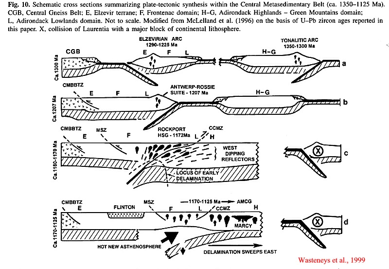
tectonic model according to Wasteneys et al., 1999 - grenptectwast.jpg
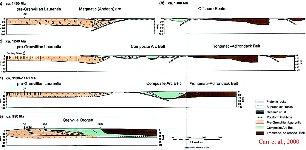
Plate
tectonic model according to Carr et al., 2000 - grenptectcarr.jpg
Maps
Bedrock Geology
of Ontario, Southern Sheet, Map 2544; Cost: $4.40 + PST/GST + $2.76
shipping: MMIC, Ministry of Northern Development and Mines, 900 Bay
St, Room M2-17 Macdonald Block, Toronto, Ontario, M7A 1C3. Telephone: 1-
800-665-4480; Pay to Treasurer of Ontario.
FIGURES